Waldbredimus
This article does not cite any sources. (December 2009) |
Waldbredimus
Waldbriedemes | |
|---|---|
Commune | |
 | |
 Coat of arms | |
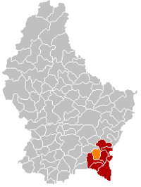 Map of Luxembourg with Waldbredimus highlighted in orange, and the canton in dark red | |
| Coordinates: 49°33′25″N 6°17′15″E / 49.5569°N 6.2875°ECoordinates: 49°33′25″N 6°17′15″E / 49.5569°N 6.2875°E | |
| Country | |
| Canton | Remich |
| Area | |
| • Total | 12.57 km2 (4.85 sq mi) |
| Area rank | 86th of 102 |
| Highest elevation | 359 m (1,178 ft) |
| • Rank | 77th of 102 |
| Lowest elevation | 170 m (560 ft) |
| • Rank | 13th of 102 |
| Population (2018) | |
| • Total | 1,116 |
| • Rank | 98th of 102 |
| • Density | 89/km2 (230/sq mi) |
| • Density rank | 68th of 102 |
| Time zone | UTC+1 (CET) |
| • Summer (DST) | UTC+2 (CEST) |
| LU0001208 | |
| Website | waldbredimus.lu |

Waldbredimus (Luxembourgish: Waldbriedemes) is a commune and small town in south-eastern Luxembourg. It is part of the canton of Remich, which is part of the district of Grevenmacher. The commune's administrative centre is Trintange.
As of 2005, the town of Waldbredimus, which lies in the centre of the commune, has a population of 376. Other towns within the commune include Ersange and Trintange.
References[]
External links[]
 Media related to Waldbredimus at Wikimedia Commons
| show Places adjacent to Waldbredimus |
|---|

| Authority control |
|---|
This article related to the geography of Remich canton is a stub. You can help Wikipedia by . |
Categories:
- Communes in Remich (canton)
- Towns in Luxembourg
- Luxembourg geography stubs