Walls of Jerusalem National Park
This article needs additional citations for verification. (October 2013) |
| Walls of Jerusalem National Park Tasmania | |
|---|---|
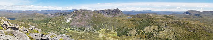
 Looking north west from Solomon's Throne. The prominent peak on the left is King Davids Peak. The Temple is on the right with Mount Jerusalem behind. | |
 | |
| Nearest town or city | Mole Creek |
| Coordinates | 41°52′08″S 146°15′31″E / 41.86889°S 146.25861°ECoordinates: 41°52′08″S 146°15′31″E / 41.86889°S 146.25861°E |
| Established | 13 December 1978[1] |
| Area | 518 km2 (200.0 sq mi)[1] |
| Location | 244 km (152 mi) NW of Hamilton |
| LGA(s) | Central Highlands, Meander Valley |
| Managing authorities | Tasmania Parks and Wildlife Service |
| Website | Walls of Jerusalem National Park |
| Footnotes | |
| Criteria | Cultural: iii, iv, vi, vii; natural: viii, ix, x |
| Reference | 181 |
| Inscription | 1982 (6th Session) |
| See also | Protected areas of Tasmania |

The Walls of Jerusalem National Park is a national park located in the Central Highlands region of Tasmania, Australia. The park is located approximately 144 km (89 mi) northwest of Hobart, east of the Cradle Mountain-Lake St Clair National Park, and west of the Central Plateau Conservation Area. It is south of Mole Creek, Tasmania, and Rowallan Lake. The national park forms part of the Tasmanian Wilderness World Heritage Area.[1]
The locality of Walls of Jerusalem is in the local government areas of Central Highlands (36%) and Meander Valley (64%) in Tasmania. The locality is about 244 kilometres (152 mi) north-west of the town of Hamilton.
Etymology and history[]
The park takes its name from the geological features of the park which are thought to resemble the walls of the city of Jerusalem. As a result, many places and features within the park also have Biblical references for names, such as Herods Gate, Lake Salome, Solomons Jewels, Damascus Gate, the Pool of Bethesda.
According to local legend, a prophet roams the wilderness, cursing the nations of the walkers who enter the park.
Features[]
The most prominent feature of the park is King Davids Peak with an elevation of 1,509 metres (4,951 ft) above sea level.
Much of the walking track consists of raised boards, from Wild Dog Creek through to Dixon's Kingdom, with the purpose of protecting the fragile alpine vegetation. Walking tracks elsewhere in the park consist of rock, rocky earth, grassland and marsh.
In film[]
Some scenes for the second episode of the BBC documentary series Walking with Dinosaurs were filmed here.[citation needed]
Geography[]
The locality has an area of 517.7 square kilometres (199.9 sq mi), all of which is occupied by the National Park.[2][3]
Road infrastructure[]
The C171 route (Mersey Forest Road) runs south just outside the north-western boundary (in the locality of Mersey Forest) to the Walls of Jerusalem car park, where it ends.[4][5]
See also[]
References[]
- ^ Jump up to: a b c "Reserve Listing - National Parks". Tasmanian Parks and Wildlife Service Website. Tasmania Parks and Wildlife Service. 17 November 2008. Retrieved 1 May 2010.
- ^ "LIST Locality and Postcode Areas". theLIST ©State of Tasmania [CC BY 3.0 AU]. 18 July 2016. Retrieved 15 September 2018.
- ^ Google (4 August 2020). "Walls of Jerusalem, Tasmania" (Map). Google Maps. Google. Retrieved 4 August 2020.
- ^ "Placenames Tasmania – Walls of Jerusalem". Placenames Tasmania. Retrieved 4 August 2020.
Select “Search”, enter 39206M, click “Search”, select row, map is displayed, click “Details”
- ^ "Tasmanian Road Route Codes" (PDF). Department of Primary Industries, Parks, Water & Environment. May 2017. Archived from the original (PDF) on 1 August 2017. Retrieved 4 August 2020.
External links[]
![]() Walls of Jerusalem National Park travel guide from Wikivoyage
Walls of Jerusalem National Park travel guide from Wikivoyage
| Authority control |
|---|
This Australian protected areas-related article is a stub. You can help Wikipedia by . |
This Central Highlands, Tasmania geography article is a stub. You can help Wikipedia by . |
- IUCN Category II
- Walls of Jerusalem National Park
- National parks of Tasmania
- Central Highlands (Tasmania)
- Protected areas established in 1978
- Wilderness areas of Tasmania
- 1978 establishments in Australia
- Tasmanian Wilderness World Heritage Area
- Localities of Central Highlands Council
- Localities of Meander Valley Council
- Towns in Tasmania
- Australian protected area stubs
- Central area council geography stubs