Wappapello, Missouri
Wappapello | |
|---|---|
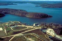 Wappapello Lake near the town of Wappapello, Missouri | |
 Wappapello Location within the state of Missouri | |
| Coordinates: 36°56′08″N 90°16′15″W / 36.93556°N 90.27083°WCoordinates: 36°56′08″N 90°16′15″W / 36.93556°N 90.27083°W | |
| Country | United States |
| State | Missouri |
| County | Wayne |
| Elevation | 361 ft (110 m) |
| Time zone | UTC-6 (Central (CST)) |
| • Summer (DST) | UTC-5 (CDT) |
| GNIS feature ID | 752753[1] |

Wappapello is an unincorporated community in southeastern Wayne County, Missouri, United States. It is located approximately thirteen miles northeast of Poplar Bluff, next to Lake Wappapello.
Wappapello was laid out in 1884 when the railroad was extended to that point.[2] The community has the name of a Native American chieftain.[3] A post office called Wappapello has been in operation since 1884.[4]
References[]
- ^ "Wappapello, Missouri". Geographic Names Information System. United States Geological Survey.
- ^ "Wayne County Place Names, 1928–1945". The State Historical Society of Missouri. Archived from the original on June 24, 2016. Retrieved January 1, 2017.
- ^ Eaton, David Wolfe (1918). How Missouri Counties, Towns and Streams Were Named. The State Historical Society of Missouri. p. 371.
- ^ "Post Offices". Jim Forte Postal History. Retrieved 1 January 2017.
Municipalities and communities of Wayne County, Missouri, United States | ||
|---|---|---|
| Cities |  | |
| Village | ||
| Townships | ||
| Unincorporated communities | ||
| Ghost towns | ||
| ||
Wappapello was founded by Samuel R. Kelley, a veteran of the Civil War. He was originally from Ohio, saw the Wappapello area as a young Union soldier, and homesteaded land there after the war.
This Wayne County, Missouri state location article is a stub. You can help Wikipedia by . |
Categories:
- Unincorporated communities in Wayne County, Missouri
- Unincorporated communities in Missouri
- Wayne County, Missouri geography stubs