Warwick (village), New York
Warwick, New York | |
|---|---|
Village | |
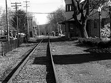
 Downtown Warwick, 2008 | |
 Location in Orange County and the state of New York. | |
 Warwick, New York Location within the state of New York | |
| Coordinates: 41°15′11″N 74°21′25″W / 41.25306°N 74.35694°WCoordinates: 41°15′11″N 74°21′25″W / 41.25306°N 74.35694°W | |
| Country | United States |
| State | New York |
| County | Orange |
| Area | |
| • Total | 2.42 sq mi (6.27 km2) |
| • Land | 2.42 sq mi (6.26 km2) |
| • Water | 0.00 sq mi (0.01 km2) |
| Elevation | 518 ft (158 m) |
| Population (2010) | |
| • Total | 6,731 |
| • Estimate (2019)[2] | 6,775 |
| • Density | 2,801.90/sq mi (1,082.02/km2) |
| Time zone | UTC-5 (Eastern (EST)) |
| • Summer (DST) | UTC-4 (EDT) |
| ZIP code | 10990 |
| Area code(s) | 845 Exchanges: 986,987,988 |
| FIPS code | 36-78355[3] |
| GNIS feature ID | 0968829[4] |
| Website | villageofwarwick |

Warwick is a village in Orange County, New York, United States, in the southeastern section of the town of Warwick. The village's population was 6,731 at the time of the 2010 census. It is part of the New York–Newark–Bridgeport, NY-NJ-CT-PA Combined Statistical Area.
History[]
This section does not cite any sources. (September 2021) |
The village was incorporated in 1867. It was originally a major passenger railroad stop, but in the latter half of the 20th century, all passenger traffic was discontinued and has been replaced entirely by freight. Many of the large colonial houses which were built when the village began have now been converted to bed and breakfasts, with one being turned into a bank and another turned into an antique museum.
During the American War for Independence, British General Burgoyne and his army camped on the outskirts of the village after their defeat at the Battle of Saratoga. Also during the American Revolution, Martha Washington stayed at Baird's Tavern, now located on Main Street in the Village at what was a crossroads of the King's Highway and a common route to Newburgh, NY.
One hundred thirty acres (42 ha) along Routes 94 and 17A in the center of the village are listed on the National Register of Historic Places as the Warwick Village Historic District. Buildings there range from the oldest in the village, the 1764 Shingle House, preserved and maintained by the Historical Society of the Town of Warwick, also known as the Warwick Historical Society, to large early 20th-century cottages built by weekend vacationers from New York City.
Geography[]
Warwick is located at 41°15′11″N 74°21′24″W / 41.25306°N 74.35667°W (41.25313, -74.356815).[5]
According to the United States Census Bureau, the village has a total area of 2.2 square miles (5.8 km2), all land.
NY-94 and NY-17A intersect in the center of the village and connect Warwick to the villages of Florida and Greenwood Lake. County highways 1A, 1B, and 13 lead into the village also. On the northern end of the village is St. Anthony Medical Center. With the termination of the passenger railroad, the only form of public transportation to New York City is NJ Transit buses, using either the 196 (express) or 197 (local) routes.
The state line between New York and New Jersey is four miles (6 km) west of the village. Hamlets surrounding the Village of Warwick include: Amity, Bellvale, Edenville, Greenwood Forest Farms, Little York, New Milford, Pine Island, and Sterling Forest.
Demographics[]
| Historical population | |||
|---|---|---|---|
| Census | Pop. | %± | |
| 1870 | 938 | — | |
| 1880 | 1,043 | 11.2% | |
| 1890 | 1,537 | 47.4% | |
| 1900 | 1,735 | 12.9% | |
| 1910 | 2,318 | 33.6% | |
| 1920 | 2,420 | 4.4% | |
| 1930 | 2,443 | 1.0% | |
| 1940 | 2,534 | 3.7% | |
| 1950 | 2,674 | 5.5% | |
| 1960 | 3,218 | 20.3% | |
| 1970 | 3,604 | 12.0% | |
| 1980 | 4,320 | 19.9% | |
| 1990 | 5,984 | 38.5% | |
| 2000 | 6,412 | 7.2% | |
| 2010 | 6,731 | 5.0% | |
| 2019 (est.) | 6,775 | [2] | 0.7% |
| U.S. Decennial Census[6] | |||
As of the census[3] of 2000, there were 6,412 people, 2,523 households, and 1,619 families residing in the village. The population density was 2,870.5 people per square mile (1,110.2/km2). There were 2,615 housing units at an average density of 1,170.7 per square mile (452.8/km2). The racial makeup of the village was 92.56% white, 3.26% black or African American, 0.19% Native American, 0.62% Asian, 0.03% Pacific Islander, 1.08% from other races, and 2.26% from two or more races. Hispanic or Latino of any race were 5.68% of the population.

There were 2,523 households, out of which 34.0% had children under the age of 18 living with them, 51.6% were married couples living together, 9.6% had a female householder with no husband present, and 35.8% were non-families. 31.9% of all households were made up of individuals, and 18.0% had someone living alone who was 65 years of age or older. The average household size was 2.46 and the average family size was 3.16.
In the village, the population was spread out, with 26.3% under the age of 18, 5.3% from 18 to 24, 28.0% from 25 to 44, 22.0% from 45 to 64, and 18.4% who were 65 years of age or older. The median age was 40 years. For every 100 females, there were 84.3 males. For every 100 females age 18 and over, there were 76.8 males.
The median income for a household in the village was $49,665, and the median income for a family was $62,984. Males had a median income of $56,641 versus $36,613 for females. The per capita income for the village was $24,648. About 3.7% of families and 4.4% of the population were below the poverty line, including 3.5% of those under age 18 and 10.9% of those age 65 or over.
References[]
- ^ "2019 U.S. Gazetteer Files". United States Census Bureau. Retrieved July 27, 2020.
- ^ a b "Population and Housing Unit Estimates". United States Census Bureau. May 24, 2020. Retrieved May 27, 2020.
- ^ a b "U.S. Census website". United States Census Bureau. Retrieved 2008-01-31.
- ^ "US Board on Geographic Names". United States Geological Survey. 2007-10-25. Retrieved 2008-01-31.
- ^ "US Gazetteer files: 2010, 2000, and 1990". United States Census Bureau. 2011-02-12. Retrieved 2011-04-23.
- ^ "Census of Population and Housing". Census.gov. Retrieved June 4, 2015.
External links[]
Municipalities and communities of Orange County, New York, United States | ||
|---|---|---|
| Cities |  | |
| Towns | ||
| Villages | ||
| CDPs | ||
| Other hamlets | ||
| ||
- Villages in New York (state)
- Villages in Orange County, New York
- Warwick, New York
- Poughkeepsie–Newburgh–Middletown metropolitan area