Washington oil field

The Washington oil field is an oil field and in Washington County, Pennsylvania.[1] It also produced natural gas.
The oil field fueled a boom in Washington County, Pennsylvania from the 1880s to the early 1900s. For a time, the McGugin Gas Well was the largest flow of natural gas in the world and provided Pittsburgh with most of its natural gas needs.
Geological components[]
The Gantz Sand, named after Washington's Gantz Oil Well, is located in the upper Devonian/lower Mississippian strata.[2][3] Its clean pebbly sandstone stretches from Washington County into north central West Virginia and produces oil and gas at depths greater than 1,700 feet (520 m).[2] The Gantz sand is frequently misidentified.[4]
Early extraction efforts[]
The Washington oil field was first tapped by Washington County Eureka Oil Company in 1861.[5] The well, which was drilled to a depth of 900 feet (270 m), was located at the Mannon farm, located at the West Amity station along the Waynesburg and Washington Railroad.[5] Other short-lived exploratory efforts were subsequently undertaken at Prosperity, Lone Pine, and South Strabane Township.[5]
Natural gas extraction[]
| Location | Pa. 18 NW of Washington |
|---|---|
| PHMC dedicated | January 6, 1967[6] |
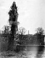
In 1880, the Morgan Oil Company drilled a well at Alexander McGuian's farm in South Strabane Township.[5] The second well attempt, reaching a depth of 2,247 feet (685 m), hit a large pocket of natural gas.[5] It was the largest flow of natural gas in the world.[5] The rush of uncaptured gas could be heard for miles.[7] Historian Earle Forrest described the event, saying that "one of nature's marvels had been uncorked".[7]
A year of wasted gas flow passed before the flow was tapped into a 6 inches (150 mm) pipe to Pittsburgh.[5] By 1885, 5 wells in the Canonsburg area had been drilled, growing to 17 by November 1, 1886.[5] The success of this well initiated the beginning and development of the great oil and gas fields in southwestern Pennsylvania.[6]
In 1967, the Pennsylvania Historical & Museum Commission erected a historical marker in honor of McGugin Gas Well well along Pennsylvania Route 18 northwest of Washington.[6] The marker has since gone missing.[6]
Oil extraction[]
 | |
| Location | W. Chestnut St. at Brookside Ave., Washington |
|---|---|
| Coordinates | 40°10′16″N 80°15′20″W / 40.17119°N 80.25546°WCoordinates: 40°10′16″N 80°15′20″W / 40.17119°N 80.25546°W |
| PHMC dedicated | October 3, 1953[8] |

In 1884, Citizens Natural Gas Company drilled a well 2,191 feet (668 m) deep on the Gantz mill property, near the Chestnut Street station of the Pennsylvania Railroad.[5] The well hit a sand formation, now known as the Gantz Sand, that produced oil, surprising the company.[5] That sand formation is known as the Gantz Sand.[5] This was the first oil well in Washington County and set off an oil boom in the area.[5][9]
Within 3 months, 21 wells were drilled throughout the county.[5] One well at a depth of 2,392 feet (729 m) by People's Light and Heat Company on the Gordon farm north of Washington was the deepest producing oil well in the world.[5] Production levels exploded in 1886; May production levels were from 4,000 barrels per day, rising to 10,120 barrels per day in June, and peaking at 17,549 barrels per day in October.[7] Contemporary reports indicate that over 100 derricks were visible from the LeMoyne well on Prospect Avenue.[7] The boom was especially notable in Murdocksville, Burgettstown, Cross Creek, and .[7] This increase in oil production signaled a shift in the center of the Pennsylvania oil industry from Northwestern Pennsylvania (home to the Drake Well) to Southwestern Pennsylvania, particularly Washington County.[10]

Washington & Jefferson College also owned oil wells; in 1885 the college purchased the old Washington Fairgrounds and transformed it into a college athletic facility (eventually Cameron Stadium) by erecting oil wells on the grounds.[11]
The boom and subsequent development lasted around 20 years, dropping significantly around shortly after the turn of the century.[7] The last oil was shipped around 1916.[8]
In 1953, the Pennsylvania Historical & Museum Commission erected a historical markers in honor of the well along West Chestnut Street in Washington.[8][nb 1] The West Virginia Division of Culture and History erected a historical marker noting the Gantz Sand in Aurora, West Virginia.[2]
Natural gas development in Marcellus Shale[]
This section needs expansion. You can help by . (January 2014) |
In the mid 2000s, Washington County would become central to the rebirth of the resource extraction industry, with the development of the hydraulic fracturing in the Marcellus Shale.
Gallery[]

Oil derricks in Finleyville
A gusher in Taylorstown


Notes[]
References[]
- ^ Hunter, John L. (January 1917). "Over Old Trails: Washington, Pennsylvania—One of the Keystone State's Educational Center—The Discovery of Oil and Gas Transforms the Straggling Village Into a Commercial Center—A Chapter of Incidents". The Oil and Gas Man's Magazine. Vol. 11–12. pp. 19–36.
- ^ a b c "Gantz Sand" (Database search). West Virginia Highway Markers Database. West Virginia Division of Culture and History.
- ^ Clapp, Frederick Gardner (1907). "Brief History of Development in Washington County". Economic Geology of the Amity Quadrangle, Eastern Washington County, Pennsylvania. United States Government Printing Office. p. 52.
- ^ Pepper, James F.; Wallace DeWitt Jr; David F. Demarest (1954). "Geology of the Bedford Shale and Berea Sandstone in the Appalachian Basin" (PDF). Geological Survey Professional Paper 259. United States Geological Survey. 119 (3094): 512–513. doi:10.1126/science.119.3094.512-a. PMID 17842742. Retrieved January 19, 2014.
- ^ a b c d e f g h i j k l m n Clapp, Frederick Gardner (1907). "Brief History of Development in Washington County". Economic Geology of the Amity Quadrangle, Eastern Washington County, Pennsylvania. United States Government Printing Office. pp. 44 to 45.
- ^ a b c d "McGugin Gas Well – PHMC Historical Markers" (Database search). Historical Marker Database. Pennsylvania Historical & Museum Commission. Retrieved January 18, 2014.
- ^ a b c d e f Branton, Harriet (2013). Washington County Chronicles: Historic Tales from Southwestern Pennsylvania. The History Press. p. 121. ISBN 9781609498696.
- ^ a b c "Gantz Oil Well – PHMC Historical Markers" (Database search). Historical Marker Database. Pennsylvania Historical & Museum Commission. Retrieved January 18, 2014.
- ^ "Gantz Oil Well Historical Marker". ExplorePAHistory.com. WITF-FM.
- ^ William, Charles E. (2008). Western Pennsylvania's Oil Heritage. Arcadia Publishing. p. 61. ISBN 9780738563046.
- ^ E. Lee, North (1991). "Chapter 2: A New College Football Team". Battling the Indians, Panthers, and Nittany Lions: The Story of Washington & Jefferson College's First Century of Football, 1890–1990. Daring Books. pp. 25–36. ISBN 978-1-878302-03-8. OCLC 24174022.
- ^ a b "Gantz Oil Well". The Historical Marker Database.
- Pennsylvania state historical marker significations
- Economic history of Pennsylvania
- Oil wells
- Oil fields of the United States
- Natural gas fields in the United States
- Geography of Washington County, Pennsylvania