Waterperry
| Waterperry | |
|---|---|
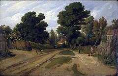
 Waterperry, Oxfordshire (1803) by William Alfred Delamotte | |
 Waterperry Location within Oxfordshire | |
| Population | 170 (parish, including Thomley) (2001 census)[1] |
| OS grid reference | SP6305 |
| Civil parish | |
| District | |
| Shire county | |
| Region | |
| Country | England |
| Sovereign state | United Kingdom |
| Post town | Oxford |
| Postcode district | OX33 |
| Dialling code | 01865 |
| Police | Thames Valley |
| Fire | Oxfordshire |
| Ambulance | South Central |
| UK Parliament | |
| Website | Waterperry |
Waterperry is a village beside the River Thame about 7 miles (11 km) east of Oxford in Oxfordshire and close to the county boundary with Buckinghamshire. The Church of England parish church of Saint Mary the Virgin is partly Saxon and has notable medieval stained glass, sculptural memorials, Georgian box pews and memorial brasses.[2]
Waterperry House is a 17th-century mansion, remodelled early in the 18th century for Sir John Curson and again around 1820.[3] It is now a house of seven bays and three storeys with a balustraded parapet and Ionic porch.[3]
The house has extensive grounds, and until 1971 housed the Waterperry School of Horticulture under Beatrix Havergal. Since 1971 the house has been owned and used as a country retreat by the School of Economic Science.[4] The gardens are now a horticultural business and visitor destination, Waterperry Gardens.[5] The 8 acres (3 ha) of gardens flower from May until the first frosts. The gardens also include rose and alpine gardens, which include the NCCPG collection of Kabschia Saxifrages, a formal knot garden, trained fruit and nursery beds and a riverside walk. The grounds also include nurseries, orchards, plant centre and teashop. Gardening courses are still taught here. The grounds host the annual Art in Action festival of art and craft each July.[6]
Demography[]
The 2011 Census incorporated the figures of Waterstock into an output area accordingly used to enlarge Waterperry's civil parish definition due to the small population of Waterstock.[7]
References[]
- ^ "Area: Waterperry with Thomley CP (Parish): Parish Headcounts". Neighbourhood Statistics. Office for National Statistics. Retrieved 21 March 2010.
- ^ Sherwood & Pevsner 1974, pp. 826–828.
- ^ a b Sherwood & Pevsner 1974, p. 828.
- ^ https://web.archive.org/web/20210109093634/http://web.archive.org/screenshot/https://www.waterperryhouse.com/ Waterperry House website.
- ^ Waterperry Gardens.
- ^ Art in Action: Waterperry House and Garden Tours
- ^ Parish: Key Statistics: Population. (2011 census In particular the maps annexed to both definitions and data sets are identical. Retrieved 2016-05-04.
Sources and further reading[]
- Lobel, Mary D, ed. (1957). A History of the County of Oxford: Volume 5: Bullingdon Hundred. Victoria County History. pp. 295–309.
- Sherwood, Jennifer; Pevsner, Nikolaus (1974). Oxfordshire. The Buildings of England. Harmondsworth: Penguin Books. pp. 826–828. ISBN 0-14-071045-0.
- Todd, John (1969) [1955]. J.S (ed.). Waterperry Church (2nd ed.).
External links[]
| Wikimedia Commons has media related to Waterperry. |
- Villages in Oxfordshire
- South Oxfordshire District
- Oxfordshire geography stubs

