Waterways, Victoria
| Waterways Melbourne, Victoria | |||||||||||||||
|---|---|---|---|---|---|---|---|---|---|---|---|---|---|---|---|
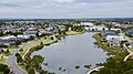
 Main Lake at Waterways, Victoria | |||||||||||||||
 Waterways | |||||||||||||||
| Coordinates | 38°00′58″S 145°07′48″E / 38.016°S 145.130°ECoordinates: 38°00′58″S 145°07′48″E / 38.016°S 145.130°E | ||||||||||||||
| Population | 2,461 (2016 census)[1] | ||||||||||||||
| Postcode(s) | 3195 | ||||||||||||||
| Location |
| ||||||||||||||
| LGA(s) | City of Kingston | ||||||||||||||
| State electorate(s) | Keysborough | ||||||||||||||
| Federal division(s) | Isaacs | ||||||||||||||
| |||||||||||||||

Waterways is a residential suburb located in Melbourne's south 25 km south of the Melbourne CBD. Originally a housing development, it is just east of Mordialloc. It is Australia's only suburb that's 20% parkland and 40% water. Over 46 hectares of wildlife sanctuary were artificially created in and around the swampy marshlands of Mordialloc Creek.
The Waterways suburb location is environmentally sensitive as it is situated directly between two conservation areas, Braeside Park and the Edithvale wetlands Edithvale-Seaford Wetlands. Planning permits are strictly regulated and gardens monitored to keep the suburb as native as possible for the abundant wildlife in the area. The Mornington Peninsula branch of the Bird Observers Club of Australia or PENBOC have documented 105 different species of birds in the area. For this reason cats are also forbidden.
History[]
Construction on Waterways Estate began in May 2000, due to end within five years. Waterways got its name from its waterways which are essentially a number of man made wetlands and giant lakes in and around the estate.
The lakes serve as a Melbourne Water filtration system for fresh water flowing down from Dandenong and Mordialloc Creeks then into Port Phillip Bay.
Although the development was due to be completed in 2006, the developer applied for, and was subsequently granted permission from Kingston Council to increase the suburb's size. The final stage of the development, called Argyle, was completed in July 2011.
Waterways was rated higher than Toorak, Brighton or Canterbury - or anywhere else, apart from the 63 people living on South Wharf - in an index of socio-economic advantage compiled from the 2011 census.
Gallery[]
Waterways Main Lake from Cafe path

Taken from the eastern end of Waterways Lake

Taken at Sunset Lagoon

Waterways aerial shot towards Port Phillip Bay
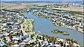
Waterways aerial shot towards Frankston
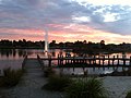
Red sunset at Waterways Lake

Taken from the pier near Waterways Boulevard
A lake at Waterways

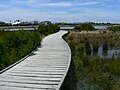
Taken from the Western boardwalk

Pier at Waterways

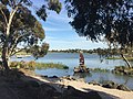
Waterways Art
Aerial shot of Main Lake from the West


References[]
- ^ Australian Bureau of Statistics (27 June 2017). "Waterways (State Suburb)". 2016 Census QuickStats. Retrieved 3 December 2017.

- ^ http://www.smh.com.au/national/melbournes-most-select-suburb-a-bit-of-a-surprise-20130328-2gxfp.html[bare URL]
- Suburbs of Melbourne
- Constructed wetlands in Australia