Weida, Thuringia
Weida | |
|---|---|
 | |
 Coat of arms | |
show Location of Weida within Greiz district | |
 Weida | |
| Coordinates: 50°46′30″N 12°3′25″E / 50.77500°N 12.05694°ECoordinates: 50°46′30″N 12°3′25″E / 50.77500°N 12.05694°E | |
| Country | Germany |
| State | Thuringia |
| District | Greiz |
| Subdivisions | 2 |
| Government | |
| • Mayor (2018–24) | Heinz Hopfe[1] |
| Area | |
| • Total | 36.48 km2 (14.09 sq mi) |
| Elevation | 231 m (758 ft) |
| Population (2020-12-31)[2] | |
| • Total | 8,318 |
| • Density | 230/km2 (590/sq mi) |
| Time zone | UTC+01:00 (CET) |
| • Summer (DST) | UTC+02:00 (CEST) |
| Postal codes | 07565–07570 |
| Dialling codes | 036603 |
| Vehicle registration | GRZ |
| Website | www.weida.de |


Weida (German: [ˈvaɪdaː] (![]() listen)) is a town in the district of Greiz, in Thuringia, Germany, situated 12 km south of Gera on the river Weida.
listen)) is a town in the district of Greiz, in Thuringia, Germany, situated 12 km south of Gera on the river Weida.
History[]
Within the German Empire (1871-1918), Weida was part of the Grand Duchy of Saxe-Weimar-Eisenach.
The Eisenhammer Weida is an historic hammer mill.
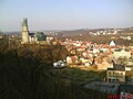
The Osterburg and city of Weida

The Oschütztal-Viadukt in Weida

References[]
- ^ Gewählte Bürgermeister - aktuelle Landesübersicht, Freistaat Thüringen, accessed 14 July 2021.
- ^ "Bevölkerung der Gemeinden, erfüllenden Gemeinden und Verwaltungsgemeinschaften in Thüringen Gebietsstand: 31.12.2020". Thüringer Landesamt für Statistik (in German). June 2021.
External links[]
- Landkreis Greiz (in English, German, and French)
| show Towns and municipalities in Greiz (district) |
|---|
| show Authority control |
|---|
This Greiz district location article is a stub. You can help Wikipedia by . |
Categories:
- Towns in Thuringia
- Greiz (district)
- Grand Duchy of Saxe-Weimar-Eisenach
- Bezirk Gera
- Greiz district geography stubs