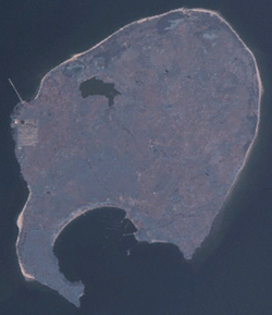
Weizhou Island
Native name: 涠洲岛 | |
|---|---|
 | |
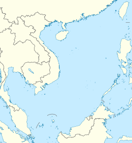 Weizhou Island Location in the South China Sea | |
| Geography | |
| Coordinates | 21°03′N 109°07′E / 21.050°N 109.117°ECoordinates: 21°03′N 109°07′E / 21.050°N 109.117°E |
| Area | 24.74 km2 (9.55 sq mi) |
| Length | 6.5 km (4.04 mi) |
| Width | 6 km (3.7 mi) |
| Coastline | 15.6 km (9.69 mi) |
| Administration | |
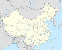
| Autonomous region | Guangxi |
| Prefecture-level city | Beihai |


Weizhou Island (simplified Chinese: 涠洲岛; traditional Chinese: 潿洲島; pinyin: Wéizhōu Dǎo) is a Chinese island in the Gulf of Tonkin. The largest island of Guangxi Zhuang Autonomous Region, Weizhou is west of Leizhou Peninsula, south of Beihai, and east of Vietnam. Administratively, it is part of Weizhou Town, Haicheng District of Beihai City. The name derives from Chinese 潿 wéi ("still water") and 洲 zhōu ("river islet").
Geography[]
Its north-south length is 6.5 kilometres (4.0 miles), east-west 6 kilometres (3.7 miles). The coast is 15.6 kilometres (9.7 miles), with 6 to 10 kilometres (3.7 to 6.2 miles) of sandy beach. Weizhou rises in the south, where Nanwan Port (南灣港; pinyin: nánwān gǎng) is located. Coral reefs have been established around the island.
- Annual average temperature: 22.6 °C (72.7 °F)
- Precipitation: 1,380 mm (54.33 inches)
Geology[]
Weizhou Island is China's youngest volcanic island.[1] Its origin is probably from a mantle plume that rose 50–32 million years ago, as a result from the collision of the Indian and Eurasian plates. When the plume reached the asthenosphere, it helped to create the South China Sea by the plume's lateral flow. An evidence that the plume still exists is that a lot of basalt has since the Pliocene erupted in the South China Sea and its adjacent areas, for example the Yandunling (烟墩岭) and Yantouling (烟头岭) volcanoes, Leiqiong (雷琼) volcano group, Weizhou Island and Xieyang Island.
The mantle below the Weizhou island has an average temperature of 1,661 °C, which is between the corresponding values of the Hawaii hotspot and the Iceland hotspot. [2]
There have been four periods of volcanic activity on the site, the first one occurred in the early Pleistocene, when mainly ash began to erupt from the bottom of the sea.
The second time, between 9–225 million years ago, started with basaltic magma eruptions, and ended with pyroclastic eruptions. This was the time with the heaviest eruptions on Weizhou and Xieyang.
The third time began with large amounts of volcanic bombs and ended with basaltic magma, this was from 200,000 to 15,000 years ago.
The fourth time, from 10,000 to 7,100 years ago, a few intermittent eruptions happened, first mainly with volcanic bombs, and in the end volcanic ash.[3]
History[]
From 1869 to 1879, the French built a Gothic-style 15 metre Catholic church in Shengtang Village (盛塘村; pinyin: shèngtáng cūn), Weizhou. Weizhou Chengzai Church (城仔教堂) was built in 1880, also by French Catholics.
Fauna[]
Along with smaller Xieyang Island, Weizhou island is a nature reserve named Beihai Weizhoudao Volcano National Geopark to preserve its volcanic features and protect rich local ecosystem engulfing 147 species of migratory and non-migratory birds, including threatened species such as black-faced spoonbills.[4][5]
Calm and shallow waters around the two islands have shown recoveries in recent years, resulting in support and attract varieties of marine life from coral reefs[6] to megafaunas more increasingly appear such as sea turtles,[7] whale sharks, endangered finless porpoises,[8][9] several species of dolphins[10] including nationally protected Chinese white dolphins,[11] and Bryde's whales.[12][13][14][15][16][17] Even a blue whale appeared in the waters in 2017.[18] Hepu Dugong National Nature Reserve established in 1992 covers nearby areas and which is the only sanctuary for dugongs in China.[citation needed]
References[]
- ^ http://www.xinhuanet.com/english/photo/2015-07/08/c_134393274.htm
- ^ "Hainan Mantle Plume and the Formation and Evolution of the South China Sea" 鄢全树 (Quan-Shu Yan);石学法 (Xue-Fa Shi) pg. 311-322
- ^ "Information from the volcano museum, on Weizhou Dao"
- ^ 林林辑 (2001). "涠洲岛鸟类保护区". 广西林业(Guangxi Forestry). Retrieved 2009-03-07.
- ^ "濒危候鸟黑脸琵鹭飞临北海涠洲岛". Guangxi Environmental Protection Bureau. 2002. Retrieved 2009-03-07.
- ^ Zhou Q.L.. Yang S.Y.. Chen B.H.. 2005. Studies on Marine Biodiversity in China (pdf). 科技导报 - Science & Technology Review. 第23卷第2期. 本栏目由中国解剖学会,中国海洋学会协办. Retrieved on Marhch 07, 2017
- ^ 来源. 2011. 国家地质公园之——广西北海涠洲岛火山地貌. 广西地质矿产勘查开发局网站.
- ^ 许海鸥. 2012. 幼鲸数次搁浅北海海滩 游客和民警接力营救(图). 南国早报. Retrieved on April 02, 2017
- ^ China News Service. 2017. 广西北海涠洲岛海豚死亡情况频发 官方加大执法力度. Retrieved on March 09, 2017
- ^ 2014. 涠洲岛景区现海豚殒命:消息不实. 中国涠洲岛网. Retrieved on March 07, 2017
- ^ 涠洲岛旅游区管委会. 涠洲岛管委会. 2017. 加强海域环境保护,期待海豚“安居”涠洲.Retrieved on March 07, 2017
- ^ 北海涠洲岛海域出现一条大鲸鱼到访。
- ^ 鲸鱼宝宝再次造访的涠洲岛海域!. 中国涠洲岛网. Retrieved on March 07, 2017
- ^ 6月小熊. 涠洲岛鲸鱼宝宝. Youku. Retrieved on March 10, 2017
- ^ 广西北海涠洲岛附近发现一条大鲸鱼. Retrieved on April 30, 2017
- ^ 2017. 好激动,今天涠洲岛海域出现鲸鱼. 中国涠洲岛网. Retrieved on April 30, 2017
- ^ louyuqi. 2017. 刷屏!涠洲岛海域拍到一鲸鱼张嘴. 北海房地产 - 楼盘网. Retrieved on April 30, 2017
- ^ 北海新人. 2017. 超近距离接触!涠洲岛有游客近距离看到鲸鱼出水,伸手就能摸到. The Beihai Newsline. Retrieved on April 30, 2017
External links[]
| Wikimedia Commons has media related to Weizhou Island. |
| Wikivoyage has a travel guide for Weizhou. |
- Local website (in Simplified Chinese)
- Nature reserves in China
- Islands of Guangxi
- Cities in Guangxi
- Gulf of Tonkin
- Islands of the South China Sea