West Cork
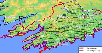
West Cork (Irish: Iarthar Chorcaí)[1] is a tourist region and municipal district in County Cork, Ireland. As a municipal district, West Cork falls within the administrative area of Cork County Council,[2] and includes the towns of Bantry, Castletownbere, Clonakilty, Dunmanway, Schull and Skibbereen, and the villages of Baltimore, Ballydehob, Courtmacsherry, Drimoleague, Durrus, Glengarriff, Leap, Rosscarbery, Timoleague and Union Hall.[3]
The westernmost part of the region consists of three main peninsulas: Beara, Sheep's Head and Mizen Head. Islands which lie off West Cork include Bere Island, Sherkin Island and Cape Clear.[4]
History and administration[]

The area's pre-history is evident in the many Iron Age burial monuments, including a large number of megalithic tombs, dolmens, standing stones and stone circles.[5]
West Cork has had a distinct identity from at least the ancient Dáirine kingdom of Corcu Loígde which once covered much of the area.[6] The historic baronies of Carbery, the largest barony in Ireland down to the nineteenth-century, Bantry, and Bear, or Bere, on Beara Peninsula, existed down from the Middle Ages. A series of coastal islands, on the coast of the baronies of Carbery West and Carbery East, are known as Carbery's Hundred Isles.
The Battle of Kinsale, fought between 1601–1602, has been described as "one of the decisive battles of the world's history. If the Irish had won that battle—and they could have won it—...England's power was shattered".[5] During the mid-19th century, parts of West Cork were severely impacted by the Great Famine.[7]
Within the Catholic Church in Ireland and the Church of Ireland (Anglican) traditions, the coastal area from Ballydehob to Timoleague was formerly contained within the Dioceses of Ross. These dioceses no longer exist separately, and now form part of the larger Roman Catholic Diocese of Cork and Ross and the Church of Ireland Diocese of Cloyne and Ross respectively.[citation needed]
As of the 21st century, West Cork is a municipal district within the administrative area of Cork County Council.[2] The district is represented by 9 councillors, and the West Cork Municipal District Office is in Clonakilty.[8]
Geography[]

The region's western terrain was formed between 360 and 374 million years ago, as part of the rising of the MacGillycuddy's Reeks and Caha Mountains mountains ranges. This occurred during the Devonian period when Ireland was part of a larger continental landmass and located south of the equator.[9] There are three main peninsulas on this side of the region: Beara, Sheep's Head and Mizen Head.
Towns in West Cork include Bantry, Dunmanway, Skibbereen, Ballydehob, Castletownbere, Schull and Rosscarbery.[10]
Transport[]
The area was linked in the early 19th century by the Cork, Bandon and South Coast Railway, sometimes known as the West Cork Railway.[11] This railway line began in Cork City, travelled across the county and had branches to Clonakilty (junction at Gaggin) and Skibbereen (junction at Drimoleague), before terminating at Bantry. The narrow-gauge Schull and Skibbereen Railway closed in 1947.[12]
The main infrastructural backbone is provided by the N71 and R586 routes.
Tourism[]
Traditionally a tourist destination, the West Cork area is marketed to tourists for its remote peninsulas (such as the Beara Peninsula, Sheep's Head and Mizen Head peninsulas), beaches such as Inchydoney, Owenahincha and Barleycove, and towns and villages such as Skibbereen, Clonakilty, Kinsale and Rosscarbery.[13] For tourism purposes, the area of West Cork is not strictly defined, but at its broadest definition it includes all parts of County Cork south and west of the River Lee with the exception of Cork city and suburbs. Road signs may be found around Cork city and elsewhere directing traffic for "The West" or "West Cork".[citation needed]
The Wild Atlantic Way tourist route spans much of the West Cork coast, including the Old Head of Kinsale, Dursey Island and Mizen Head.[14]
Gallery[]

Lough Hyne, outside Skibbereen

Mizen Head, the most southwesterly point of Ireland

Altar Wedge Tomb, (c. 3000–2000 BC), Toormore Bay, outside Schull

Drombeg stone circle, Glandore. Active c. 1100 - 800 BC

Gougane Barra, 6th century Christian monastery site near the source of the River Lee
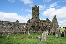
Timoleague Friary, founded 1240[15]

Garden on Garnish Island in Glengarriff harbour

Street in Kinsale


References[]
Notes[]
- ^ "Taxonomy - Term - Iarthar Chorcaí". corkcoco.ie. Cork County Council. Retrieved 2 July 2021.
- ^ Jump up to: a b "Municipal District of West Cork". corkcoco.ie. Cork County Council. 2 July 2021.
- ^ "West Cork Municipal District". Local Area Plans. Cork County Council. Retrieved 2 July 2021.
- ^ "West Cork islands". westcorkislands.com. West Cork Island Federation. Retrieved 3 July 2021.
- ^ Jump up to: a b O'Halloran 1916.
- ^ O'Halloran 1916, XIX (Lords of the Soil of West Cork): "The whole [West Cork] territory lying between the Bandon River and the Kenmare River was formerly called Corca Laidhe"
- ^ Hickey 2002.
- ^ "How your Council Works". corkcoco.ie. Cork County Council. Retrieved 2 July 2021.
West Cork Municipal District Office [..] Location of Municipal District Office:, Clonakilty
- ^ Bourke et al. 2011, p. 3.
- ^ "Towns in West Cork". explorewestcork.ie. West Cork People. Retrieved 20 June 2019.
- ^ "History of the West Cork Railway Line". modelvillage.ie. West Cork Model Railway Village. Retrieved 3 July 2021.
- ^ "Schull station - Terminus of Schull & Skibbereen 3ft gauge tramway". eiretrains.com. Eiretrains Irish Railways. Retrieved 20 June 2019.
- ^ "West Cork Highlights". discoverireland.ie. Fáilte Ireland. Archived from the original on 20 June 2019.
- ^ "Wild Atlantic Way". corkcoco.ie. Cork County Council. Retrieved 3 July 2021.
The Wild Atlantic Way’s southern starting point is the coastal town of Kinsale [..] There are 3 Signature Discovery Points located in West Cork. These are Dursey Island, Mizen Head and the Old Head of Kinsale
- ^ "Proceedings of the Royal Irish Academy: Archaeology, Celtic studies, history, linguistics and literature". Royal Irish Academy. 1970: 93. Cite journal requires
|journal=(help)
Sources[]
- Bourke, Edward; Hayden, Alan; Lynch, Ann; O'Sullivan, Michael (2011). Skellig Michael, Co. Kerry: The Monastery and South Peak: Archaeological Stratigraphic Report: Excavations 1986–2010. Dublin: Department of Culture, Heritage and the Gaeltacht. OCLC 795846647.
- Hickey, Patrick (2002). Famine in West Cork: The Mizen Peninsula Land and People 1800-1852. Mercier Press. ISBN 9781856353885.
- O'Halloran, W (1916). Early Irish History and Antiquities, and the History of West Cork. Sealy, Bryers and Walker.

- Geography of County Cork
- Tourist attractions in County Cork