West Pit
| West Pit | |
|---|---|
 | |
 | |
| Type | Local Nature Reserve |
| Location | Cherry Hinton, Cambridgeshire |
| OS grid | TL 484 558 |
| Area | 4.3 hectares |
| Managed by | Cambridge City Council |

West Pit is a 4.3 hectare Local Nature Reserve in Cherry Hinton, on the south-eastern outskirts of Cambridge.[1] It is part of the Cherry Hinton Pit biological Site of Special Scientific Interest (SSSI), which includes the neighbouring East Pit.[2][3]
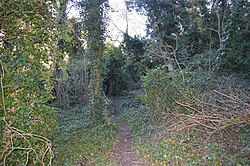
This former chalk quarry is now steeply sloping woodland with a caravan park in the centre. The woodland has been designated an SSSI due to the presence of a plant on the British Red List of Threatened Species, the moon carrot.[1][2]
The site has been designated a Local Nature Reserve (LNR) by Cambridge City Council, which shows it as one LNR[1] and East Pit and Limekiln Close as another LNR.[4] However, the LNRs are confused on the Natural England website. One is shown as Limekiln Close and West Pit on the details page,[5] but the map only covers Limekiln Close.[6] The other LNR is shown on the details page as East Pit,[7] whereas the map covers both East and West Pits.[8]
There is access to the site from the entrance to the caravan park on Limekiln Road.
| Wikimedia Commons has media related to West Pit. |
References[]
- ^ a b c "West Pit". Cambridge City Council. Retrieved 15 January 2017.
- ^ a b "Cherry Hinton Pit citation" (PDF). Sites of Special Scientific Interest. Natural England. Retrieved 30 November 2016.
- ^ "Map of Cherry Hinton Pit". Sites of Special Scientific Interest. Natural England. Retrieved 30 November 2016.
- ^ "Limekiln Close and East Pit local nature reserve". Cambridge City Council. Retrieved 16 January 2017.
- ^ "Limekiln Close and West Pit". Local Nature Reserves. Natural England. 20 February 2013. Retrieved 15 January 2017.
- ^ "Map of Limekiln Close and West Pit". Local Nature Reserves. Natural England. Retrieved 15 January 2017.
- ^ "East Pit". Local Nature Reserves. Natural England. 20 February 2013. Retrieved 15 January 2017.
- ^ "Map of East Pit". Local Nature Reserves. Natural England. Retrieved 15 January 2017.
- Local Nature Reserves in Cambridgeshire