West St Leonards railway station
West St Leonards | |
|---|---|
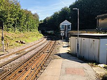
 The platforms at West St Leonards, looking north | |
| Location | Bulverhythe, Hastings, East Sussex England |
| Grid reference | TQ788090 |
| Managed by | Southeastern |
| Platforms | 2 |
| Other information | |
| Station code | WLD |
| Classification | DfT category E |
| Key dates | |
| 1887[1] | Station opens |
| Passengers | |
| 2016/17 | |
| 2017/18 | |
| 2018/19 | |
| 2019/20 | |
| 2020/21 | |
| Notes | |
Passenger statistics from the Office of Rail and Road | |

West St Leonards railway station is on the Hastings line in the south of England and is one of four stations that serve Hastings, East Sussex. It is 60 miles 59 chains (97.7 km) down the line from London Charing Cross. The station and all trains serving it are operated by Southeastern.
Services[]
As of May 2010 the typical off-peak service is one train per hour to London Charing Cross via Tunbridge Wells, and one train per hour to Hastings.[2]
| Preceding station | Following station | |||
|---|---|---|---|---|
| Crowhurst | Southeastern Hastings Line |
St Leonards Warrior Square | ||
History[]
West St Leonards station was constructed in 1887. It is just north of St Leonards West Marina railway station, a now disused station that was the earliest station serving the area.
Rail layout[]
Railway stations in Hastings | |||||||||||||||||||||||||||||||||||||||||||||||||||||||||||||||||||||||||||||||||||||||||||||||||||||||||||||||
|---|---|---|---|---|---|---|---|---|---|---|---|---|---|---|---|---|---|---|---|---|---|---|---|---|---|---|---|---|---|---|---|---|---|---|---|---|---|---|---|---|---|---|---|---|---|---|---|---|---|---|---|---|---|---|---|---|---|---|---|---|---|---|---|---|---|---|---|---|---|---|---|---|---|---|---|---|---|---|---|---|---|---|---|---|---|---|---|---|---|---|---|---|---|---|---|---|---|---|---|---|---|---|---|---|---|---|---|---|---|---|---|
| |||||||||||||||||||||||||||||||||||||||||||||||||||||||||||||||||||||||||||||||||||||||||||||||||||||||||||||||
The Hastings Line (operated by Southeastern) joins the East Coastway Line (operated by Southern) immediately east of West St Leonards, at Bo-Peep junction, just before entering Bo-Peep tunnel. Plans were made for platforms to be built on the East Coastway Line for interchange but Hastings Borough Council decided that there was no economic or passenger benefit as interchange was already available at the next station (Warrior Square).
The nature of the station layout, with the platforms built on a sharp bend, means that for safety reasons all trains from first to last, must be manually despatched by platform staff.
Gallery[]

The station building

A 1914 Railway Clearing House map of lines around West St Leonards railway station.


References[]
| Wikimedia Commons has media related to West St Leonards railway station. |
- ^ "station opens". Archived from the original on 11 July 2011. Retrieved 30 July 2009.
- ^ Network Rail Timetable May 2010: Table 206
Coordinates: 50°51′11″N 0°32′24″E / 50.853°N 0.540°E
This article on a railway station in South East England is a stub. You can help Wikipedia by . |
- Transport in Hastings
- Railway stations in East Sussex
- Former South Eastern Railway (UK) stations
- Railway stations in Great Britain opened in 1887
- Railway stations served by Southeastern
- South East England railway station stubs