Weurt
Weurt | |
|---|---|
Village | |
 | |
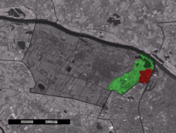 The village (red) and the statistical district (light green) of Weurt in the municipality of Beuningen. | |
| Coordinates: 51°51′N 5°49′E / 51.850°N 5.817°ECoordinates: 51°51′N 5°49′E / 51.850°N 5.817°E | |
| Country | Netherlands |
| Province | Gelderland |
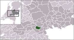
| Municipality | Beuningen |
| Population (31 December 2008) | |
| • Total | 2,439 |
| Time zone | UTC+1 (CET) |
| • Summer (DST) | UTC+2 (CEST) |
| Postal code | 6551 |
| Dialing code | 024 |
| Website | beuningen.nl |

Weurt is a village in the Dutch province of Gelderland. It is a part of the municipality of Beuningen, and lies about 0.1 km West of Nijmegen.
Weurt was a separate municipality until 1818, when it was merged with Beuningen.[1]
The village Weurt had a population of around 2,230 on 1 January 2005.[2] The statistical area "Weurt", which also can include the surrounding countryside, had a population of around 2470.[2]

Weurt, church de Sint-Andreaskerk
References[]
- ^ Ad van der Meer and Onno Boonstra, Repertorium van Nederlandse gemeenten, KNAW, 2011.
- ^ Jump up to: a b Statistics Netherlands (CBS), Statline: Kerncijfers wijken en buurten 2003-2005
| Authority control |
|
|---|
This Gelderland location article is a stub. You can help Wikipedia by . |
Categories:
- Populated places in Gelderland
- Former municipalities of Gelderland
- Beuningen
- Gelderland geography stubs