Beuningen
Beuningen | |
|---|---|
Municipality | |
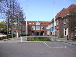 Beuningen town hall | |
  Flag Coat of arms | |
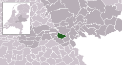 Location in Gelderland | |
| Coordinates: 51°52′N 5°47′E / 51.867°N 5.783°ECoordinates: 51°52′N 5°47′E / 51.867°N 5.783°E | |
| Country | Netherlands |
| Province | Gelderland |
| Government | |
| • Body | Municipal council |
| • Mayor | (acting) (D66) |
| Area | |
| • Total | 47.09 km2 (18.18 sq mi) |
| • Land | 43.65 km2 (16.85 sq mi) |
| • Water | 3.44 km2 (1.33 sq mi) |
| Elevation | 9 m (30 ft) |
| Population (January 2019)[4] | |
| • Total | 25,882 |
| • Density | 593/km2 (1,540/sq mi) |
| Demonym(s) | Beuninger |
| Time zone | UTC+1 (CET) |
| • Summer (DST) | UTC+2 (CEST) |
| Postcode | 6550–6551, 6640–6645 |
| Area code | 024, 0487 |
| Website | www |

Beuningen (Dutch pronunciation: [ˈbøːnɪŋə(n)] (![]() listen)) is a municipality and a town in the eastern Netherlands. The municipality consists of the towns Beuningen, Ewijk, Winssen and Weurt. 1.5 kilometres (1 mi) to the north lies the river Waal
listen)) is a municipality and a town in the eastern Netherlands. The municipality consists of the towns Beuningen, Ewijk, Winssen and Weurt. 1.5 kilometres (1 mi) to the north lies the river Waal
Beuningen lies adjacent to the A73 (Nijmegen-Venlo, on the south side) and A50 (Zwolle-Eindhoven, in the west) motorway interchange. East of Beuningen lies the city Nijmegen. Beuningen had a population of 25,882 in 2019. There is a restored windmill in the town, De Haag.
Population centres[]
- Beuningen
- Ewijk
- Weurt
- Winssen
History[]
The area in and around Beuningen was inhabited by the Romans. There are regularly excavations done in which Roman rests are found. In the 15th century there stood a small castle: Blanckenburgh. It was probably destroyed during the Eighty Years' War by Maurice of Orange. Until about 1900 Beuningen was a poor farmers village, often struck by floods. Nevertheless, there were a few rich families, mostly farmers with a lot of land, who paid the highest tax in the area. On januari 1st 1818 the municipality annexed town Weurt in the East and juli 1st 1980 the town Ewijk on the West.
Nowadays Beuningen has grown to a suburb of Nijmegen, with a lot of new neighbourhoods.
Topography[]

Dutch Topographic map of the municipality of Beuningen, June 2015.
Monuments[]
There are several monuments in Beuningen. Here are a few (in chronological order):
- Blanckenburgh tower, 15th century
- De Haag Mill, 1704
- Kloosterstraat farm, 1774
- Olden Tempel, 1838
- Large Waardhuizenstraat T-farm, 1850 - 1900
- Mausoleum of Van 't Lindenhout, 1861
- Cornelius church, 1900-1901
- Vinkendael, 1900
- Coach house, ca. 1913
- Holy Heart statue, 1920
- Stone factory the Bunswaard, 1920
See also[]
Notable people[]
- Willem Joseph baron van Ghent tot Drakenburgh (1626 in Winssen – 1672) a 17th-century Dutch admiral
- Willie Smits (born 1957, in Weurt) a trained forester, microbiologist, conservationist, animal rights activist, wilderness engineer and social entrepreneur in Borneo
- Bas van Bemmelen (born 1989 in Beuningen) a volleyball player with the Netherlands men's national volleyball team
Gallery[]
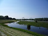
Waal bij Ewijk

Beuningen, church: de Corneliuskerk

Ewijk, Beuningen, scheepvaart op de Waal

Sculptuur in Beuningen
Weurt, Beuningen


References[]
- ^ "Carol van Eert" (in Dutch). Gemeente Beuningen. Archived from the original on 19 June 2014. Retrieved 19 June 2014.
- ^ "Kerncijfers wijken en buurten 2020" [Key figures for neighbourhoods 2020]. StatLine (in Dutch). CBS. 24 July 2020. Retrieved 19 September 2020.
- ^ "Postcodetool for 6641AE". Actueel Hoogtebestand Nederland (in Dutch). Het Waterschapshuis. Retrieved 19 June 2014.
- ^ "Bevolkingsontwikkeling; regio per maand" [Population growth; regions per month]. CBS Statline (in Dutch). CBS. 1 January 2019. Retrieved 1 January 2019.
External links[]
 Media related to Beuningen, Gelderland at Wikimedia Commons
- Official website
| show Places adjacent to Beuningen |
|---|
| show Municipalities of Gelderland |
|---|

| Authority control |
|---|
This Gelderland location article is a stub. You can help Wikipedia by . |
- Beuningen
- Municipalities of Gelderland
- Populated places in Gelderland
- Gelderland geography stubs