Lochem
Lochem | |
|---|---|
City and municipality | |
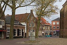
 City centre of Lochem | |
 Flag Coat of arms | |
 Location in Gelderland | |
| Coordinates: 52°10′N 6°25′E / 52.167°N 6.417°ECoordinates: 52°10′N 6°25′E / 52.167°N 6.417°E | |
| Country | Netherlands |
| Province | Gelderland |
| Government | |
| • Body | Municipal council |
| • Mayor | Sebastiaan van 't Erve (GL) |
| Area | |
| • Total | 215.94 km2 (83.37 sq mi) |
| • Land | 213.03 km2 (82.25 sq mi) |
| • Water | 2.91 km2 (1.12 sq mi) |
| Elevation | 14 m (46 ft) |
| Population (January 2019)[4] | |
| • Total | 33,590 |
| • Density | 158/km2 (410/sq mi) |
| Demonym(s) | Lochemer |
| Time zone | UTC+1 (CET) |
| • Summer (DST) | UTC+2 (CEST) |
| Postcode | 7210–7218, 7240–7245 |
| Area code | 0573, 0575 |
| Website | lochem |

Lochem (Dutch pronunciation: [ˈlɔxəm] (![]() listen)) is a city and municipality in the province of Gelderland in the Eastern Netherlands. In 2005, it merged with the municipality of Gorssel, retaining the name of Lochem. As of 2019, it had a population of 33,590.
listen)) is a city and municipality in the province of Gelderland in the Eastern Netherlands. In 2005, it merged with the municipality of Gorssel, retaining the name of Lochem. As of 2019, it had a population of 33,590.
Population centres[]

The city of Lochem is the municipality's main population centre. The hamlet of Barchem and Laren were already comprised in the municipality of Lochem before 2005. Formerly in the municipality of Gorssel, Almen, Eefde (immediately north of Zutphen), Epse and Gorssel itself became part of the municipality of Lochem, as well as the hamlet of Harfsen.
City of Lochem[]
Lochem, 18 km (11 mi) east of Zutphen, received city rights in 1233.[5] Until the 17th century, it was often besieged and burnt down. After 1700, it became a small market town for the farmers in its surroundings.
The village of Laren has a castle called Huis Verwolde. In summer, guided tours of this castle are organised for tourists. On its estate there is a tree, said to be the thickest tree in the Netherlands ( "de dikke boom van Verwolde").
Transport[]
Lochem is served by Lochem railway station, on the Zutphen–Glanerbeek railway.
Notable people[]
- Johan van Dorth (1574 in Salvador – 1624), schout of Lochem and nobleman and general of the Dutch Republic
- Robert Jasper van der Capellen (1743 in Eefde – 1814) a scion from the noble regenten family Van der Capellen from Guelders
- Carel de Villeneuve (1897 in Lochem – 1974) a lawyer and director of business associations in colonial Indonesia during the 1920s–1940s
- Hans Jorritsma (born 1949 in Lochem) a retired field hockey player, competed at the 1976 Summer Olympics
- Irma Boom (born 1960 in Lochem) a Dutch graphic designer—who specializes in book making
Gallery[]
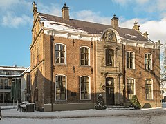
Former town hall
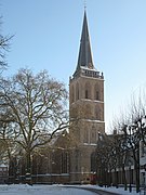
De Gudulakerk
Monumental street light
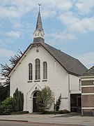
De Witte Kerk

Monumental house on the Markt

House at 't Ei

River Berkel from De Graaf Ottoweg

Bicycle bridge across the Berkel

Zwiep, windmill: de Zwiepse Molen

Lochem, artwork and bridge across Twentekanaal

Huis Verwolde

Lochemse Berg, trees in the fog on the Hoge Enk


References[]
- ^ "Burgemeester van 't Erve" [Mayor van 't Erve] (in Dutch). Gemeente Lochem. Archived from the original on 21 December 2014. Retrieved 17 June 2014.
- ^ "Kerncijfers wijken en buurten 2020" [Key figures for neighbourhoods 2020]. StatLine (in Dutch). CBS. 24 July 2020. Retrieved 19 September 2020.
- ^ "Postcodetool for 7241AA". Actueel Hoogtebestand Nederland (in Dutch). Het Waterschapshuis. Archived from the original on 21 September 2013. Retrieved 17 June 2014.
- ^ "Bevolkingsontwikkeling; regio per maand" [Population growth; regions per month]. CBS Statline (in Dutch). CBS. 1 January 2019. Retrieved 1 January 2019.
- ^ "Stad Lochem", Mijn Gelderland. Retrieved on 14 April 2017.
External links[]
 Media related to Lochem at Wikimedia Commons
- Official website
| show Places adjacent to Lochem |
|---|
| show Municipalities of Gelderland |
|---|

| show Authority control |
|---|
- Lochem
- Municipalities of Gelderland
- Populated places in Gelderland
- Cities in the Netherlands
- Achterhoek