Bronckhorst
Bronckhorst | |
|---|---|
Municipality | |
 | |
 Flag Coat of arms | |
 Location in Gelderland | |
| Coordinates: 52°3′N 6°18′E / 52.050°N 6.300°ECoordinates: 52°3′N 6°18′E / 52.050°N 6.300°E | |
| Country | Netherlands |
| Province | Gelderland |
| Established | 1 January 2005[1] |
| Government | |
| • Body | Municipal council |
| • Mayor | (PvdA) |
| Area | |
| • Total | 286.42 km2 (110.59 sq mi) |
| • Land | 283.50 km2 (109.46 sq mi) |
| • Water | 2.92 km2 (1.13 sq mi) |
| Elevation | 13 m (43 ft) |
| Highest elevation | 43 m (141 ft) |
| Population (January 2019)[6] | |
| • Total | 36,212 |
| • Density | 128/km2 (330/sq mi) |
| Time zone | UTC+1 (CET) |
| • Summer (DST) | UTC+2 (CEST) |
| Postcode | Parts of 6900, 7000 and 7200 ranges |
| Area code | 0313, 0314, 0575 |
| Website | www |


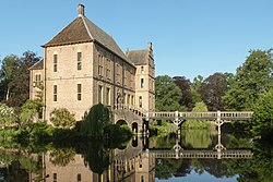
Bronckhorst (pronounced [ˈbrɔŋkɦɔrst] (![]() listen)) is a municipality in Gelderland, the Netherlands. The municipality is the result of a merger of the former municipalities Hengelo, Hummelo en Keppel, Steenderen, Vorden and Zelhem, on 1 January 2005. The new municipality is named after the medieval castle of the Bronckhorst family, who once ruled this area.
listen)) is a municipality in Gelderland, the Netherlands. The municipality is the result of a merger of the former municipalities Hengelo, Hummelo en Keppel, Steenderen, Vorden and Zelhem, on 1 January 2005. The new municipality is named after the medieval castle of the Bronckhorst family, who once ruled this area.
The seat of the municipality is Hengelo.
Population centres[]
|
Formerly in Hengelo:
Formerly in Hummelo en Keppel: Formerly in Vorden:
|
Formerly in Zelhem:
Formerly in Steenderen:
|
Keppel[]
Keppel received city rights in 1404.
Gallery[]
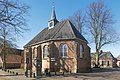
Bronkhorst, chapel

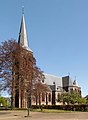
Hengelo, church (de Remigiuskerk) in the street

Laag Keppel, reformed churc

Halle, reformed church
Baak, church: the Sint-Martinuskerk

Steenderen, windmill: de Bronkhorster Molen

Wittebrink, windmill: de Wittebrinkse Molen

between Olburgen and Doesburg, the Zwarte Schaar near inlaatwerk 4028


Notable people[]

- Henrica Iliohan (1850 in Vorden – 1921) a Dutch-born American woman suffragist
- Henk Zeevalking (1922 in Laag-Keppel – 2005) a Dutch politician and co-founder of the Democrats 66 (D66)
- Prof Jan Remmelink (1922 in Zelhem - 2003) was Attorney General of the High Council of the Netherlands 1968/1989
- Annemarie Jorritsma (born 1950 in Hengelo) a Dutch politician
Sport[]
- Leo Klein Gebbink (born 1968 in Zelhem) a former field hockey midfield player
- Klaas-Jan Huntelaar (born 1983 in Voor-Drempt) a Dutch professional footballer with over 450 club caps
References[]
- ^ "Gemeentelijke indeling op 1 januari 2005" [Municipal divisions on 1 January 2005]. cbs.nl (in Dutch). CBS. Retrieved 20 June 2014.
- ^ "Samenstelling en taakverdeling" [Members and tasks] (in Dutch). Gemeente Bronckhorst. Archived from the original on 14 July 2014. Retrieved 20 June 2014.
- ^ "Kerncijfers wijken en buurten 2020" [Key figures for neighbourhoods 2020]. StatLine (in Dutch). CBS. 24 July 2020. Retrieved 19 September 2020.
- ^ "Postcodetool for 7255KA". Actueel Hoogtebestand Nederland (in Dutch). Het Waterschapshuis. Retrieved 20 June 2014.
- ^ "Bronkhorst Algemeen". Natuurlijk Achterhoek. Retrieved 27 August 2020.
- ^ "Bevolkingsontwikkeling; regio per maand" [Population growth; regions per month]. CBS Statline (in Dutch). CBS. 1 January 2019. Retrieved 1 January 2019.
External links[]
 Media related to Bronckhorst at Wikimedia Commons
- Official website
| show Places adjacent to Bronckhorst |
|---|
| show Municipalities of Gelderland |
|---|

This Gelderland location article is a stub. You can help Wikipedia by . |
- Bronckhorst
- Municipalities of Gelderland
- Achterhoek
- Gelderland geography stubs