Steenderen
Steenderen | |
|---|---|
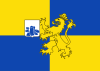 Flag  Coat of arms | |
| Coordinates: 52°3′52″N 6°11′12″E / 52.06444°N 6.18667°E | |
| Country | Netherlands |
| Province | Gelderland |
| Municipality | Bronckhorst |

|
| |
| Country | Netherlands |
| Province | Gelderland |
| Area - Land - Water |
50.23 km² 48.73 km² 1.50 km² |
| Population (2004) - Density |
5,087 104/km² |
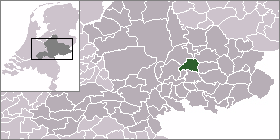
Steenderen is a former municipality and a town in the eastern Netherlands.
Population centres[]
- Baak
- Bronkhorst
- Rha
- Steenderen
Gallery[]

Steenderen, view to the village with two church towers

Steenderen, church (de Sint Remigiuskerk) in the street
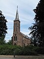
Steenderen, church: de Sint Willibrorduskerk

between Steenderen and Bronkhorst, Bronkhorstermolen


External links[]
| hide Authority control | |
|---|---|
| General |
|
| National libraries | |
Coordinates: 52°04′N 6°11′E / 52.067°N 6.183°E
This Gelderland location article is a stub. You can help Wikipedia by . |
Categories:
- Populated places in Gelderland
- Former municipalities of Gelderland
- Bronckhorst
- Gelderland geography stubs