Wewela, South Dakota
Wewela, South Dakota
wiwíla | |
|---|---|
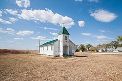 United Church of Christ in Wewela, South Dakota | |
 Wewela, South Dakota | |
| Coordinates: 43°00′38″N 99°46′51″W / 43.01056°N 99.78083°WCoordinates: 43°00′38″N 99°46′51″W / 43.01056°N 99.78083°W | |
| Country | United States |
| State | South Dakota |
| County | Tripp |
| Elevation | 2,136 ft (651 m) |
| Population (2019) | |
| • Total | 5 |
| Time zone | UTC-6 (Central (CST)) |
| • Summer (DST) | UTC-5 (CDT) |
| ZIP code | 57578 |
| Area code(s) | 605 |
| GNIS feature ID | 1258935[1] |

Wewela (Lakota: wiwíla;[2] "A spring") is an unincorporated community in Tripp County, South Dakota, United States. Wewela is located on U.S. Route 183 near the Nebraska border, south of Colome.
The community most likely was named for springs near the original town site, Wewela meaning "small spring" in the Sioux language.[3]
References[]
- ^ "US Board on Geographic Names". United States Geological Survey. 2007-10-25. Retrieved 2008-01-31.
- ^ Bright, William (2004). Native American Placenames of the United States. Norman, OK: University of Oklahoma Press. p. 563.
- ^ Federal Writers' Project (1940). South Dakota place-names, v.1-3. University of South Dakota. p. 68.
Municipalities and communities of Tripp County, South Dakota, United States | ||
|---|---|---|
| Cities |  | |
| Town | ||
| CDP | ||
| Other communities | ||
| Indian reservation | ||
| Footnotes | ‡This populated place also has portions in an adjacent county or counties | |
| ||
This South Dakota state location article is a stub. You can help Wikipedia by . |
Categories:
- Unincorporated communities in Tripp County, South Dakota
- Unincorporated communities in South Dakota
- South Dakota geography stubs