Weybridge
| Weybridge | |
|---|---|
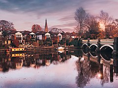 The Old Bridge on River Wey | |
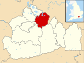
 Weybridge Location within Surrey | |
| Area | 13.73 km2 (5.30 sq mi) |
| Population | 15,449 (2011 census)[1] or 29,837 (Built-up Area, which extends to Byfleet)[2] |
| • Density | 1,125/km2 (2,910/sq mi) |
| OS grid reference | TQ0764 |
| Civil parish |
|
| District | |
| Shire county | |
| Region | |
| Country | England |
| Sovereign state | United Kingdom |
| Post town | WEYBRIDGE |
| Postcode district | KT13 |
| Dialling code | 01932 |
| Police | Surrey |
| Fire | Surrey |
| Ambulance | South East Coast |
| UK Parliament | |

Weybridge /ˈweɪbrɪdʒ/ is a town by the River Wey in the Elmbridge district of Surrey. It is bounded to the north by the River Thames at the mouth of the Wey, from which it gets its name. It is an outlying suburban town within the Greater London Urban Area, situated seven miles (eleven kilometres) northeast of Woking and 16 miles (26 kilometres) southwest of central London. House prices are well above the national average:[3] as of 2008, six of the ten most expensive streets in South East England (defined as the official government region, which excludes Greater London) were in Weybridge.[4] and is the 2nd most expensive place to buy property outside of London as of 2021.[5]
Weybridge, based on its parish bounds, forms three wards of the United Kingdom or can be divided into the Thames Street and town centre area, the Queens Road area on top of Monument Hill, most of Brooklands and St George's Hill.
History[]

An old tradition claims that this is the point where Julius Caesar crossed the Thames in 55BC.[6]
Weybridge appears in the Domesday Book of 1086 as Webrige and Webruge held partly by Chertsey Abbey; partly by an Englishman from the abbey; and partly by Herfrid from William the Conqueror's half-brother, Bishop Odo of Bayeux. Its Domesday assets were: 6 hides; 1½ ploughs, 32 acres (13 hectares) of meadow, wood worth 9 hogs. It rendered four pounds per year to its feudal overlords.[7] It was much smaller than today's post town, and about one quarter of the size of neighbouring Walton.[8]
In 1235, Henry III granted to William son of Daniel Pincerna, for his homage and service, two mills on the River Wey, one above the 'bridge of Wey,' and the other at Feyreford (a place which no longer exists) at an annual rent of five silver marks.[9]
Until the late 18th century, Weybridge was as a very small village with a river crossing, seed milling to make flour and nurseries would continue to provide the major source of home-grown income until the 20th century[9] but no tanneries, major coaching houses, shops, markets, forges or gunpowder works are documented for example in the medieval period. The earliest monuments on the tower wall of St James's Church are 15th-century plaques, and the Church was rebuilt in 1848 with a south aisle added in 1864.[10] In 1537, the south-west of Walton on Thames extra-territorially a manor house affiliated to Weybridge on what was a border of Weybridge and Walton, Oatlands Palace, was built by Henry VIII, which was where he married his fifth wife Catherine Howard. When it was demolished in 1650, bricks from its walls helped to line the then-new Wey Navigation canal.
In 1571, commissioners were appointed to report on the condition of the bridge across the Wey. They stated that for some years it had been so decayed as to be "unsafe for passengers, and that it was now ruinous . . . if the queen should be at her house at Oatlands and the waters should rise, 'as often they do,' she could not pass to her forest to hunt". It was accordingly ordered that a new bridge – a horse-bridge like the last – should be built, wood being used for its construction, as stonework would be too costly. The expense was to be borne by the queen, as the land on either side belonged to her.[9]St George's Hill was the site of the Diggers' Commune in the 1640s.
At the bottom of Monument Hill, within the definition of the town centre is a monument to the Princess Frederica Charlotte, Duchess of York, erected by public subscription in 1820 from the remains of the original Seven Dials Monument that stood in St Martin's Lane, London until 1773. The Duchess is buried in St. James's Churchyard.
In the 19th century, Oatlands broke away from the parish of Walton on Thames to become a village in its own right, eventually to have three places of worship. Influenced by the secondary manor of Weybridge, the forerunner of Oatlands Palace (at which time the heart of the grounds became the Oatlands Park Hotel), the post town adopted Oatlands as its only village in the 19th century.
The entomologist Horace Donisthorpe visited Weybridge Heath to investigate the ant colony.
Weybridge grew into a commuter town with the advent of the fast train link into London Waterloo and many new houses have been built around the Oatlands Park and Broadwater Lake area.
Railway[]

Weybridge railway station was opened by the London and Southampton Railway in 1838. After the station was opened, development of what was until then only a village began and gradually Weybridge became a town. Large houses were built on St George's Hill from 1911 by local builder and developer Walter George Tarrant of Byfleet.
Plant life[]
In Weybridge Heath, many rare species of insects (particularly ants), rare birds and insectivorous plant have been recorded. The heath was allowed to become vastly overgrown in recent years, but recently Surrey Wildlife Trust invoked a scrub clearance plan in an attempt to restore this valuable habitat.
Industry and commerce[]

Weybridge is the British headquarters of Alliance Boots, CHEP UK, Sony Corporation, Procter & Gamble, and JTI (formerly Gallaher). Abbey Business Centres also has a presence in the town.
Eurotax Glass, owners and publishers of Glass's Guide, pricing bible to the motor industry, and regional paper publisher Newsquest are based in Weybridge.
In addition, retailing also forms part of the local economy, and a range of retailers are represented in the town centre.
In popular culture[]
- In H. G. Wells' novel The War of the Worlds (1897), Weybridge was the location of a battle in which a Martian fighting machine was destroyed. The title of chapter 12 of the book is: "What I saw of the destruction of Weybridge and Shepperton". The battle also featured in the track "The Artilleryman and the Fighting Machine" from Jeff Wayne's Musical Version of The War of the Worlds (1978), and in a graphic novel by Ian Edginton and D'Israeli (2006), adapted from Wells' book.
- In John Wyndham's novel The Kraken Wakes (1953), the main characters are stopped in their attempt to reach Cornwall on a dinghy, through a flooded England, in the whereabouts of Weybridge.
- In Salman Rushdie's novel The Satanic Verses (1988), Weybridge was referred to by one of Saladin Chamcha's interrogators as his place of residence and also (incorrectly) as that of The Beatles (in fact only John Lennon and Ringo Starr lived in Weybridge for short periods).[11]
Education[]

Two schools for 11- to 18-year-olds serve Weybridge, Heathside School and 6th Form Centre in the town itself and St George's College in nearby Addlestone. There is also Brooklands College, for sixth form students in further education focussing particularly in BTECs. There are many primary schools to serve 4-11 year olds: St James Primary School St Charles Borromeo Catholic Primary, as well as Oatlands infant school, Manby Lodge infant school and Cleves Junior School. Also, St George’s Junior School in Thames Street - the primary school for St George’s senior school.
Sport[]
At the top of Monument Hill, adjacent to the cricket green is a World War I war memorial.
Weybridge also has a variety of sports clubs including ECB Premier League club Weybridge Cricket Club, Weybridge Vandals Rugby Club, Weybridge Vandals Cricket Club, Elmbridge Canoe Club, Weybridge Bowls Club, Weybridge Rowing Club, Weybridge Mariners Recreational Rowing Club and Weybridge Sprinters Club, all serving the area for many years. Addlestone & Weybridge Town F.C. was the main football club in Weybridge until becoming defunct in 1985. However, there are several amateur teams in the local area, like Abbey Rangers Football club.
Notable people[]
This section needs additional citations for verification. (February 2018) |
Notable residents, past and present, include:
- Abbey Clancy – model
- Benjamin Scott - Chamberlain of the City of London, lived at Heath House (now named Lorimar House) and founded the Congregational chapel (now Weybridge United Reformed Church)[12]
- Cliff Richard – pop singer
- Denny Laine - guitarist in pop band Wings
- E.M. Forster – author, wrote Howards End in Weybridge, 1908–10
- Eamonn Holmes & Ruth Langsford, broadcasters
- Edmund McCorquodale (1881–1904), cricketer
- Engelbert Humperdinck – pop singer
- Fanny Kemble – author, actor and anti-slavery supporter, lived at Eastlands in Brooklands Road
- Frank Finlay – actor
- Gilbert O'Sullivan – singer-songwriter
- Gordon Mills - music industry manager and songwriter
- Jacqueline Bisset – actress, was born in the town.
- John Austin (1790–1859), legal philosopher
- John Lennon – lived in Weybridge from 1964 to 1968, in a mansion called Kenwood on St George's Hill
- Kelvin MacKenzie – journalist
- Lucy O'Donnell – the "Lucy" of the 1967 Beatles song "Lucy in the Sky with Diamonds"
- Martine McCutcheon – singer and actress
- Maurice Hewlett – novelist and husband of Hilda Hewlett, was born in the town
- Michael Aspel – television presenter, patron of the Weybridge Society, awarded the Freedom of Elmbridge in recognition of his many campaigns and charities in the Borough
- Mike Yarwood, TV personality
- Nina Bawden – lived in Weybridge in the 1960s and 70s, Carrie's War was written at her house in Hanger Hill, since demolished along with the private 'Wallop School'
- Pete Ham – Welsh musician and lead singer of Badfinger. Ham lived in Weybridge, where he later committed suicide in April 1975 at the age of 27.
- Paul Draper - Lead singer of Mansun.
- Peter Crouch – footballer, Stoke City F.C.
- Petr Čech – Czech footballer, Arsenal F.C.
- Ringo Starr – lived in Weybridge from 1965–1968 in a mansion called Sunny Heights
- Shilpa Shetty – Bollywood Actress
- Sir Colin Davis – conductor, was born in the town.
- Sir Thomas Hopsonn – Vice-admiral, retired to Weybridge in 1702.
- Theo Paphitis – businessman and TV personality, Dragons' Den and entrepreneur
- Tom Eastwood – Musician
- Tom Jones – lived in Weybridge in the late 1960s
- Will Hughes – footballer for Watford F.C.. Born in Weybridge, before moving to Derby aged two
- You Me at Six – Pop punk band.
Demography and housing[]
| Output area | Detached | Semi-detached | Terraced | Flats and apartments | Caravans/temporary/mobile homes | Shared between households[1] |
|---|---|---|---|---|---|---|
| Weybridge North | 439 | 435 | 398 | 642 | 0 | 0 |
| Weybridge South | 499 | 328 | 336 | 908 | 2 | 15 |
| St Georges Hill | 1,152 | 379 | 340 | 696 | 0 | 0 |
The average level of accommodation in the region composed of detached houses was 28%, the average that was apartments was 22.6%.
| Output area | Population | Households | % Owned outright | % Owned with a loan | hectares[1] |
|---|---|---|---|---|---|
| Weybridge North | 4,347 | 1,914 | 27 | 37 | 233 |
| Weybridge South | 4,600 | 2,088 | 31 | 33 | 202 |
| St Georges Hill | 6,502 | 2,567 | 33 | 40 | 938 |
The proportion of households in the settlement who owned their home outright compares to the regional average of 35.1%. The proportion who owned their home with a loan compares to the regional average of 32.5%. The remaining % is made up of rented dwellings (plus a negligible % of households living rent-free).
References[]
- ^ Jump up to: a b c Key Statistics; Quick Statistics: Population Density Archived 11 February 2003 at the Wayback Machine United Kingdom Census 2011 Office for National Statistics Retrieved 21 November 2013
- ^ UK Census (2011). "Local Area Report – Weybridge Built-up area sub division (1119885117)". Nomis. Office for National Statistics. Retrieved 23 August 2020.
- ^ "Weybridge House Prices". GetAgent. GetAgent. Retrieved 13 May 2021.
- ^ The most expensive streets in the South West, 2008 Archived 16 May 2008 at the Wayback Machine, The Times, 19 February 2008.
- ^ "UK House Prices Trends". GetAgent. GetAgent. Retrieved 13 May 2021.
- ^ Mason, John; Mason, Ann. Hadfield, John (ed.). The Shell Guide to England. London: Book Club Associates. p. 221.
- ^ Surrey Domesday Book Archived 15 July 2007 at the Wayback Machine
- ^ Map of the Parishes in Elmbridge Archived 22 January 2021 at the Wayback Machine Victoria County History H.E. Malden (ed.) 1912. Retrieved 14 December 2013
- ^ Jump up to: a b c H.E. Malden, ed. (1911). "Parishes: Weybridge". A History of the County of Surrey: Volume 3. Institute of Historical Research. Archived from the original on 23 October 2013. Retrieved 14 December 2013.
- ^ National Heritage List for England, 2012 ed., entry 4/85 Church of St. James 19.10.51 GV II
- ^ Rushdie, Salman (1989). The Satanic Verses. United States and United Kingdom: Viking. pp. 164. ISBN 9780670825370.
- ^ "The Story of the Church and "Revelations in Stone"". Weybridge United Reformed Church. 2015. Archived from the original on 11 January 2015. Retrieved 10 November 2020.
External links[]
- Weybridge Lifestyle and News
- 1st Weybridge (Brooklands Own) Scout Group, est 1907 the oldest scout group in Surrey, if not the UK
- History of Weybridge
- The York Column Monument and Monument Green History
- The River Wey and Wey Navigations Community Site
- Aerial photographs of Weybridge
- Weybridge News & Mail
- Population figures (PDF)
- Walton & Weybridge Film Society
| show Authority control |
|---|
- Weybridge, Surrey
- Towns in Surrey
- Borough of Elmbridge
- Populated places on the River Thames