Whitleyville, Tennessee
Whitleyville, Tennessee | |
|---|---|
Unincorporated community | |
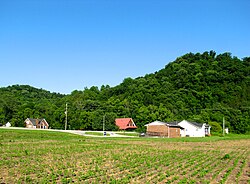 Buildings along SR 56 in Whitleyville | |
 Whitleyville | |
| Coordinates: 36°26′43″N 85°40′19″W / 36.44528°N 85.67194°WCoordinates: 36°26′43″N 85°40′19″W / 36.44528°N 85.67194°W | |
| Country | United States |
| State | Tennessee |
| County | Jackson |
| Elevation | 531 ft (162 m) |
| Time zone | UTC-6 (Central (CST)) |
| • Summer (DST) | UTC-5 (CDT) |
| ZIP code | 38588 |
| Area code(s) | 931 |
| GNIS feature ID | 1274422[1] |


Whitleyville is an unincorporated rural village in Jackson County, Tennessee, United States. Whitleyville is located on Jennings Creek, a tributary of the Cumberland River, and is concentrated along State Routes 56 and 135 6.2 miles (10.0 km) north of Gainesboro.[2] Whitleyville has a small bank branch office, and a post office serving ZIP code 38588,[3] as well as several scattered residences separated by farm fields and open grassland.
References[]
- ^ "Whitleyville". Geographic Names Information System. United States Geological Survey.
- ^ Jackson County, Tennessee General Highway Map (PDF) (Map). Tennessee Department of Transportation. 1998. Retrieved November 10, 2011.
- ^ United States Postal Service (2012). "USPS - Look Up a ZIP Code". Retrieved 2012-02-15.
Municipalities and communities of Jackson County, Tennessee, United States | ||
|---|---|---|
| Town | ||
| CDP | ||
| Unincorporated communities | ||
| ||
This Jackson County, Tennessee geography–related article is a stub. You can help Wikipedia by . |
Categories:
- Unincorporated communities in Jackson County, Tennessee
- Unincorporated communities in Tennessee
- Middle Tennessee geography stubs