Wihr-au-Val
Wihr-au-Val | |
|---|---|
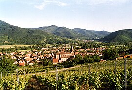 Wihr-au-Val seen from the vineyards | |
 Coat of arms | |
show Location of Wihr-au-Val | |
 Wihr-au-Val | |
| Coordinates: 48°03′15″N 7°12′23″E / 48.0542°N 7.2064°ECoordinates: 48°03′15″N 7°12′23″E / 48.0542°N 7.2064°E | |
| Country | France |
| Region | Grand Est |
| Department | Haut-Rhin |
| Arrondissement | Colmar-Ribeauvillé |
| Canton | Wintzenheim |
| Intercommunality | |
| Government | |
| • Mayor (2020–2026) | Gabriel Burgard[1] |
| Area 1 | 12.54 km2 (4.84 sq mi) |
| Population (Jan. 2018)[2] | 1,253 |
| • Density | 100/km2 (260/sq mi) |
| Time zone | UTC+01:00 (CET) |
| • Summer (DST) | UTC+02:00 (CEST) |
| INSEE/Postal code | 68368 /68230 |
| Elevation | 288–960 m (945–3,150 ft) (avg. 320 m or 1,050 ft) |
| 1 French Land Register data, which excludes lakes, ponds, glaciers > 1 km2 (0.386 sq mi or 247 acres) and river estuaries. | |


Wihr-au-Val (German: Weier im Thal) is a communes in the Haut-Rhin department in Grand Est in north-eastern France.
Population[]
| Year | Pop. | ±% |
|---|---|---|
| 2006 | 1,184 | — |
| 2007 | 1,186 | +0.2% |
| 2008 | 1,210 | +2.0% |
| 2009 | 1,237 | +2.2% |
| 2010 | 1,264 | +2.2% |
| 2011 | 1,272 | +0.6% |
| 2012 | 1,271 | −0.1% |
| 2013 | 1,270 | −0.1% |
| 2014 | 1,270 | +0.0% |
| 2015 | 1,269 | −0.1% |
| 2016 | 1,265 | −0.3% |
See also[]
References[]
- ^ "Répertoire national des élus: les maires". data.gouv.fr, Plateforme ouverte des données publiques françaises (in French). 2 December 2020.
- ^ "Populations légales 2018". INSEE. 28 December 2020.
| Wikimedia Commons has media related to Wihr-au-Val. |
| show Authority control |
|---|
This Haut-Rhin geographical article is a stub. You can help Wikipedia by . |
Categories:
- Communes of Haut-Rhin
- Haut-Rhin geography stubs