Wijnjewoude
Wijnjewoude
Wynjewâld | |
|---|---|
Village | |
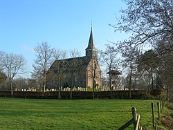 Wijnjewoude church | |
 Coat of arms | |
 Location in Opsterland municipality | |
 Wijnjewoude Location in the Netherlands | |
| Coordinates: Coordinates: 53°03′22″N 6°12′22″E / 53.05611°N 6.20611°E | |
| Country | |
| Province | |
| Municipality | |
| Population (2017) | |
| • Total | 2,025 |
| Time zone | UTC+1 (CET) |
| • Summer (DST) | UTC+2 (CEST) |
| Postal code | 9241 |
| Telephone area | 0516 |
| Website | Official |

Wijnjewoude (West Frisian: Wynjewâld) is a village in the municipality of Opsterland in the east of Friesland, the Netherlands. It had a population of around 2,025 in January 2017.[1] The villages of Duurswoude and Wijnjeterp were founded in the late Middle Ages next to one-another. After World War II the villages started to expand, and merged into a single village called Wijnjewoude in 1974.[2]
Notable people[]
- Teus Hagen (1945), internet pioneer.[3]
References[]
- ^ Kerncijfers wijken en buurten 2017 - CBS Statline
- ^ "Historie van Wijnjewoude". Friesland Wonderland (in Dutch). Retrieved 23 June 2020.
- ^ Helmut Neumann: Das Lexikon der Internetpioniere. Flintbek, 2001.
External links[]
![]() Media related to Wijnjewoude at Wikimedia Commons
Media related to Wijnjewoude at Wikimedia Commons
This Friesland location article is a stub. You can help Wikipedia by . |
Categories:
- Populated places in Friesland
- Geography of Opsterland
- Friesland geography stubs