Woodlands, Calgary
Woodlands | |
|---|---|
Neighbourhood | |
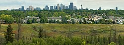 Residences overlooking Fish Creek Park | |
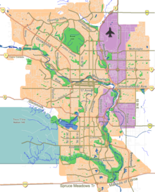 Woodlands Location of Woodlands in Calgary | |
| Coordinates: 50°56′29″N 114°06′32″W / 50.94139°N 114.10889°WCoordinates: 50°56′29″N 114°06′32″W / 50.94139°N 114.10889°W | |
| Country | |
| Province | |
| City | |
| Quadrant | SW |
| Ward | 13 |
| Established | 1976 |
| Government | |
| • Mayor | Jyoti Gondek |
| • Administrative body | Calgary City Council |
| • Councillor | Dan McLean |
| Area | |
| • Total | 2.9 km2 (1.1 sq mi) |
| Elevation | 1,070 m (3,510 ft) |
| Population (2006)[2] | |
| • Total | 6,529 |
| • Average Income | $71,234 |
| Website | Woodlands Community Association |

Woodlands is a residential neighbourhood in the southwest quadrant of Calgary, Alberta. The community is bordered by Fish Creek Provincial Park to the south, 24 Street SW to the west, Anderson Road SW to the north, and 14 Street SW to the east. The Canyon Meadows Golf course is entirely contained within the boundaries of Woodlands.
Woodlands was established in 1976. It is represented in the Calgary City Council by the Ward 13 councillor.[1]
Demographics[]
In the City of Calgary's 2012 municipal census, Woodlands had a population of 6,201 living in 2,397 dwellings, a 0% increase from its 2011 population of 6,201.[3] With a land area of 2.8 km2 (1.1 sq mi), it had a population density of 2,210/km2 (5,740/sq mi) in 2012.[4][3]
Residents in this community had a median household income of $71,234 in 2000, and there were 14.2% low income residents living in the neighbourhood.[5] As of 2000, 22.9% of the residents were immigrants. A proportion of 11.6% of the buildings were condominiums or apartments, and 24.9% of the housing was used for renting.[2]
See also[]
References[]
- ^ a b "Calgary Elections". City of Calgary. 2017. Retrieved November 12, 2017.
- ^ a b City of Calgary (2006). "Woodlands Community Statistics" (PDF). Retrieved 2007-05-09.
- ^ a b "2012 Civic Census Results" (PDF). City of Calgary. 2012. Retrieved February 4, 2013.
- ^ "Community Boundaries" (Esri shapefile). City of Calgary. Retrieved February 5, 2013.
- ^ City of Calgary (2004). "Ward 13 Profile" (PDF). Retrieved 2007-05-09.
External links[]
Places adjacent to Woodlands, Calgary | |
|---|---|
This Calgary-related article is a stub. You can help Wikipedia by . |
- Neighbourhoods in Calgary
- Calgary stubs