Woryny
Woryny | |
|---|---|
Village | |
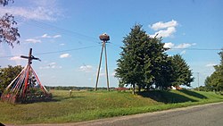 Wood storks nest in Woryny | |
| Country | |
| Voivodeship | Warmian-Masurian |
| County | Bartoszyce |
| Gmina | Gmina Górowo Iławeckie |
Woryny [vɔˈrɨnɨ] (German: Worienen) is a village in the administrative district of Gmina Górowo Iławeckie, within Bartoszyce County, Warmian-Masurian Voivodeship, in northern Poland, close to the border with the Kaliningrad Oblast of Russia.[1]
History[]
On the south-west edge of the village there are traces of a settlement known as Góra Zamkowa (Castle Hill), most likely what was described in medieval documents as Woria or Wore, existing in the pre-Teutonic Knights period. The stronghold in Woryny took advantage of the defensive qualities of being situated at the top of a hill overlooking a stream. The two-part settlement is separated by a dry moat and was most likely inhabited only in one part, with farm animals kept in the second fragment.[2]
Throughout the Napoleonic Battle of Eylau in February 1807 the French generals Nicolas Dahlmann (General Colonel, Commandant des chasseur à cheval de la Garde Impériale francaise) and Jean-Joseph Ange d'Hautpoul were buried at the manor house of Worienen but later exhumed and transferred to France.[3]
Until 1945 the area was part of the German Province of East Prussia, Worienen was occupied by the Soviet Red Army in February 1945 throughout the East Prussian Offensive. After World War II the area was placed under Polish administration according to the post-war Potsdam Agreement. Germans fled or were expelled and replaced with Poles, many of them expelled from the Polish areas annexed by the Soviet Union or forced to settle in the area throughout the Operation Vistula in 1947.
References[]
- ^ "Central Statistical Office (GUS) - TERYT (National Register of Territorial Land Apportionment Journal)" (in Polish). 2008-06-01.
- ^ Gmina Górowo Iławeckie. "Przewodnik Gmina Górowo Iławeckie" (PDF).
- ^ extract of the Church records
Coordinates: 54°18′31″N 20°34′12″E / 54.30861°N 20.57000°E

This Bartoszyce County location article is a stub. You can help Wikipedia by . |
- Villages in Bartoszyce County
- Bartoszyce County geography stubs