Wriezen
Wriezen | |
|---|---|
 Panorama | |
 Coat of arms | |
show Location of Wriezen within Märkisch-Oderland district | |
 Wriezen | |
| Coordinates: 52°43′00″N 14°07′59″E / 52.71667°N 14.13306°ECoordinates: 52°43′00″N 14°07′59″E / 52.71667°N 14.13306°E | |
| Country | Germany |
| State | Brandenburg |
| District | Märkisch-Oderland |
| Subdivisions | 4 Ortsteile |
| Government | |
| • Mayor (2017–25) | Karsten Ilm[1] (CDU) |
| Area | |
| • Total | 94.54 km2 (36.50 sq mi) |
| Elevation | 10 m (30 ft) |
| Population (2020-12-31)[2] | |
| • Total | 7,125 |
| • Density | 75/km2 (200/sq mi) |
| Time zone | UTC+01:00 (CET) |
| • Summer (DST) | UTC+02:00 (CEST) |
| Postal codes | 16269 |
| Dialling codes | 033456 |
| Vehicle registration | MOL |
| Website | www.wriezen.de |


Wriezen is a town in the district Märkisch-Oderland, in Brandenburg, Germany. It is situated 11 km southeast of Bad Freienwalde.
Demography[]
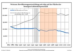
Development of Population since 1875 within the Current Boundaries (Blue Line: Population; Dotted Line: Comparison to Population Development of Brandenburg state; Grey Background: Time of Nazi rule; Red Background: Time of Communist rule)
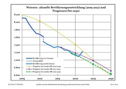
Recent Population Development and Projections (Population Development before Census 2011 (blue line); Recent Population Development according to the Census in Germany in 2011 (blue bordered line); Official projections for 2005-2030 (yellow line); for 2017-2030 (scarlet line); for 2020-2030 (green line)


|
|
|
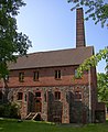
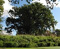
Photogallery[]
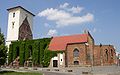
- St. Mary’s Church


- Haselberg
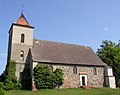
Church
Distillery

Fieldstone wall
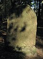
Grave of horse Pipifax

Sparkasse (Savings bank)


Sons and daughters of the town[]
- Henning von Boehmer (born 1943), journalist and commercial lawyer, former general secretary of the International Chamber of Commerce - Germany (ICC)
- Cornelia Froboess (born 1943), actress, teen idol and pop singer
- Michael Succow (born 1941), biologist and agronomist, an honorary citizen of the municipality Lüdersdorf / Biesdorf, now district Wriezen
See also[]
References[]
- ^ Landkreis Märkisch-Oderland Wahl der Bürgermeisterin / des Bürgermeisters, accessed 1 July 2021.
- ^ "Bevölkerung im Land Brandenburg nach amtsfreien Gemeinden, Ämtern und Gemeinden 31. Dezember 2020". Amt für Statistik Berlin-Brandenburg (in German). June 2021.
- ^ Detailed data sources are to be found in the Wikimedia Commons.Population Projection Brandenburg at Wikimedia Commons
External links[]
![]() Media related to Wriezen at Wikimedia Commons
Media related to Wriezen at Wikimedia Commons
| show Towns and municipalities in Märkisch-Oderland |
|---|
| show Authority control |
|---|
This Brandenburg location article is a stub. You can help Wikipedia by . |
- Towns in Brandenburg
- Localities in Märkisch-Oderland
- Province of Brandenburg
- Bezirk Frankfurt
- Brandenburg geography stubs