Yonezawa, Yamagata
This article needs additional citations for verification. (January 2017) |
Yonezawa
米沢市 | |
|---|---|
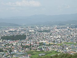 Overview of downtown Yonezawa | |
 Flag  Seal | |
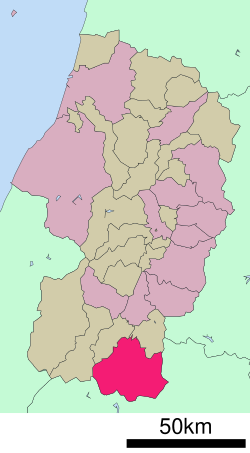 Location of Yonezawa in Yamagata Prefecture | |
 Yonezawa | |
| Coordinates: 37°55′20.1″N 140°07′0.4″E / 37.922250°N 140.116778°ECoordinates: 37°55′20.1″N 140°07′0.4″E / 37.922250°N 140.116778°E | |
| Country | Japan |
| Region | Tōhoku |
| Prefecture | Yamagata |
| Government | |
| • Mayor | Masaru Nakagawa (since December 2015) |
| Area | |
| • Total | 548.51 km2 (211.78 sq mi) |
| Population (February 2020) | |
| • Total | 81,707 |
| • Density | 150/km2 (390/sq mi) |
| Time zone | UTC+9 (Japan Standard Time) |
| - Tree | Kometsuga (Tsuga diversifolia) |
| - Flower | Azumashakunage (Rhododendron metternichii Sieb. et Zucc. var. pentamerum Maxim) |
| Phone number | 0238-22-5111 |
| Address | 5-2-25 Kanaike, Yonezawa-shi, Yamagata-ken 992-8501 |
| Website | Official website |


Yonezawa (米沢市, Yonezawa-shi) is a city in Yamagata Prefecture, Japan. As of 1 February 2020, the city had an estimated population of 81,707 in 33278 households,[1] and a population density of 150 persons per km2. The total area of the city is 548.51 square kilometres (212 sq mi). Yonezawa is most famous for its local delicacies (apples, Yonezawa beef, and carp) and for being a castle town that was once home to the Uesugi clan, including the daimyō Uesugi Yozan.
Geography[]
Yonezawa is located in the southeast corner of Yamagata Prefecture. The southern and eastern portions of the city are river basins surrounded by large mountains, forming the Yonezawa Basin. The southern portion of the city has a complex terrain with several rivers and alternating ridges and valleys orientated east to west. The Mogami River flows through the city. Part of the city is within the borders of the Bandai-Asahi National Park.
Neighboring municipalities[]
- Yamagata Prefecture
- Fukushima Prefecture
- Fukushima, Fukushima
- Kitakata, Fukushima
- Inawashiro, Fukushima
- Kitashiobara, Fukushima
Demographics[]
Per Japanese census data,[2] the population of Yonezawa has remained relatively steady for the past 70 years .
| Year | Pop. | ±% |
|---|---|---|
| 1920 | 75,039 | — |
| 1930 | 77,716 | +3.6% |
| 1940 | 82,770 | +6.5% |
| 1950 | 94,649 | +14.4% |
| 1960 | 96,991 | +2.5% |
| 1970 | 92,764 | −4.4% |
| 1980 | 92,823 | +0.1% |
| 1990 | 94,760 | +2.1% |
| 2000 | 95,396 | +0.7% |
| 2010 | 89,392 | −6.3% |
Climate[]
Yonezawa has a Humid continental climate (Köppen climate classification Cfa) with large seasonal temperature differences, with warm to hot (and often humid) summers and cold (sometimes severely cold) winters. Precipitation is significant throughout the year, but is heaviest from August to October. The average annual temperature in Yonezawa is 11.4 °C. The average annual rainfall is 1438 mm with September as the wettest month. The temperatures are highest on average in August, at around 25.1 °C, and lowest in January, at around -1.3 °C.[3]
History[]
The area of present-day Yonezawa was part of ancient Dewa Province and was controlled in the Sengoku period by the Date clan. The famed warlord Date Masamune was born in Yonezawa. During the Edo period, the area became Yonezawa Domain under the Tokugawa shogunate, ruled by the Uesugi clan. After the start of the Meiji period, the area was organized into , Yamagata Prefecture.
The city of Yamagata was established on April 1, 1889, with the establishment of the modern municipalities system
Government[]
Yonezawa has a mayor-council form of government with a directly elected mayor and a unicameral city legislature of 24 members. The city contributes three members to the Yamagata Prefectural Assembly. In terms of national politics, the city is part of Yamagata District 3 of the lower house of the Diet of Japan.
List of mayor of Yonezawa[]
|
| |||||||||||||||||||||||||||||||||||||||||||||||||||||||||
Economy[]
The economy of Yamagata is based on agriculture, horticulture, light manufacturing and tourism.
Education[]
Colleges and universities[]
- Yamagata University Yonezawa campus
- Yonezawa Women's Junior College
Primary and secondary education[]
Yonezawa has 18 public elementary schools and eight public middle schools operated by the city government and four public high schools operated by the Yamagata Prefectural Board of Education. There are also two private high schools.
Transportation[]
Railway[]
![]() East Japan Railway Company - Yamagata Shinkansen
East Japan Railway Company - Yamagata Shinkansen
![]() East Japan Railway Company - Ōu Main Line
East Japan Railway Company - Ōu Main Line
![]() East Japan Railway Company - Yonesaka Line
East Japan Railway Company - Yonesaka Line
Highways[]
 Tōhoku-Chūō Expressway – Yonezawa IC
 National Route 13
 National Route 121
 National Route 287
 National Route 399
Local attractions[]
- Yonezawa City Uesugi Museum
- Yonezawa Castle
- Yonezawa Onsen
- Shirabu Onsen (in gorges of Otaru River south of Yonezawa)
International relations[]
Twin towns — Sister cities[]
Japan[]
- Takanabe, Miyazaki, since 1981
- Jōetsu, Niigata, since 1981
- Okinawa, Okinawa, since 1994
- Tōkai, Aichi, since 1999
Worldwide[]
 Taubaté, Brazil,[4] since January 28, 1974
 Moses Lake, Washington, USA, since May 1, 1981
Notable people from Yonezawa[]
This section does not cite any sources. (February 2014) |
- Junzaburo Ban, actor
- Itō Chūta, architect
- Takehiko Endo, politician
- Yamashita Gentarō, admiral, Imperial Japanese Navy
- Masami Kobayashi, admiral, Imperial Japanese Navy
- Mutsuo Minagawa, Nippon Professional Baseball player
- Chūichi Nagumo, admiral, Imperial Japanese Navy
- Ikeda Shigeaki, politician
- Hirata Tosuke, Meiji period statesman
References[]
- ^ Yonezawa City official statistics (in Japanese)
- ^ Yonezawa population statistics
- ^ Yonezawa climate data
- ^ "International Exchange". List of Affiliation Partners within Prefectures. Council of Local Authorities for International Relations (CLAIR). Retrieved 21 November 2015.
External links[]
| Wikimedia Commons has media related to Yonezawa, Yamagata. |
| Wikivoyage has a travel guide for Yonezawa. |
| Wikivoyage has a travel guide for Shirabu Onsen. |
- Official Website (in Japanese)
- Yonezawa Sightseeing Website
| show Authority control |
|---|
- Yonezawa, Yamagata
- Cities in Yamagata Prefecture