Young County, New South Wales

From Wikipedia, the free encyclopedia

Map all coordinates using: OpenStreetMap 
Download coordinates as: KML
Young
New South Wales
Young NSW.PNG
Location in New South Wales
Lands administrative divisions around Young:
Mootwingee Yungnulgra Killara
Mootwingee Young Werunda
Tandora Livingstone Livingstone

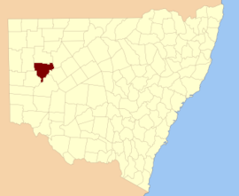
Young County is one of the 141 Cadastral divisions of New South Wales. It includes the area to the west of Wilcannia. The Darling River is the south-eastern boundary.

Young County was named in honour of the twelfth Governor of New South Wales, Sir John Young, First Baron Lisgar (1807-1876).[1]

Parishes within this county[]

A full list of parishes found within this county; their current LGA and mapping coordinates to the approximate centre of each location is as follows:

Parish LGA Coordinates
Unincorporated 31°24′20″S 142°38′27″E / 31.40556°S 142.64083°E / -31.40556; 142.64083 (Ardennes)
Central Darling Shire 31°11′21″S 143°02′42″E / 31.18917°S 143.04500°E / -31.18917; 143.04500 (Barbston)
Unincorporated 31°13′50″S 142°28′52″E / 31.23056°S 142.48111°E / -31.23056; 142.48111 (Baroorangee)
Unincorporated 31°13′56″S 142°35′44″E / 31.23222°S 142.59556°E / -31.23222; 142.59556 (Blanche)
Central Darling Shire 31°31′12″S 143°07′00″E / 31.52000°S 143.11667°E / -31.52000; 143.11667 (Blumenthal)
Central Darling Shire 31°49′31″S 143°05′13″E / 31.82528°S 143.08694°E / -31.82528; 143.08694 (Bonley)
Central Darling Shire 31°27′37″S 143°13′52″E / 31.46028°S 143.23111°E / -31.46028; 143.23111 (Brougham)
Unincorporated 31°38′06″S 142°39′29″E / 31.63500°S 142.65806°E / -31.63500; 142.65806 (Broughton)
Unincorporated 31°30′37″S 142°31′49″E / 31.51028°S 142.53028°E / -31.51028; 142.53028 (Bungaroo)
Central Darling Shire 31°18′36″S 143°13′05″E / 31.31000°S 143.21806°E / -31.31000; 143.21806 (Cameron)
Unincorporated 31°38′42″S 142°45′23″E / 31.64500°S 142.75639°E / -31.64500; 142.75639 (Clayton)
Cobrilla Central Darling Shire
Central Darling Shire 31°25′18″S 142°46′55″E / 31.42167°S 142.78194°E / -31.42167; 142.78194 (Comarto)
Central Darling Shire 32°03′16″S 142°55′10″E / 32.05444°S 142.91944°E / -32.05444; 142.91944 (Corega)
Central Darling Shire 31°38′59″S 143°17′48″E / 31.64972°S 143.29667°E / -31.64972; 143.29667 (Coromerry)
Culpaulin Central Darling Shire
Unincorporated 31°35′39″S 142°45′22″E / 31.59417°S 142.75611°E / -31.59417; 142.75611 (Cuthowara)
Central Darling Shire 31°41′22″S 142°52′10″E / 31.68944°S 142.86944°E / -31.68944; 142.86944 (Dalglish)
Central Darling Shire 31°22′10″S 143°19′26″E / 31.36944°S 143.32389°E / -31.36944; 143.32389 (Darling)
Unincorporated 31°16′07″S 142°41′50″E / 31.26861°S 142.69722°E / -31.26861; 142.69722 (Daubeny)
Central Darling Shire 31°34′39″S 143°12′57″E / 31.57750°S 143.21583°E / -31.57750; 143.21583 (Desailly)
Central Darling Shire 31°30′32″S 143°00′26″E / 31.50889°S 143.00722°E / -31.50889; 143.00722 (Dickens)
Dry Lake Central Darling Shire 31°24′59″S 143°12′40″E / 31.41639°S 143.21111°E / -31.41639; 143.21111 (Dry Lake)
Central Darling Shire 31°21′01″S 143°25′14″E / 31.35028°S 143.42056°E / -31.35028; 143.42056 (Evelyn)
Central Darling Shire 31°38′55″S 143°11′50″E / 31.64861°S 143.19722°E / -31.64861; 143.19722 (Garland)
Central Darling Shire 31°09′32″S 143°29′01″E / 31.15889°S 143.48361°E / -31.15889; 143.48361 (Goode)
Unincorporated 31°33′09″S 142°39′27″E / 31.55250°S 142.65750°E / -31.55250; 142.65750 (Greville)
Unincorporated 31°18′46″S 142°39′49″E / 31.31278°S 142.66361°E / -31.31278; 142.66361 (Griffiths)
Central Darling Shire 31°34′33″S 142°52′41″E / 31.57583°S 142.87806°E / -31.57583; 142.87806 (Jennings)
Central Darling Shire 31°16′32″S 143°32′44″E / 31.27556°S 143.54556°E / -31.27556; 143.54556 (Kambula)
Central Darling Shire 31°49′01″S 142°58′29″E / 31.81694°S 142.97472°E / -31.81694; 142.97472 (King)
Central Darling Shire 31°14′39″S 143°26′55″E / 31.24417°S 143.44861°E / -31.24417; 143.44861 (Kopago)
Unincorporated 31°23′26″S 142°29′20″E / 31.39056°S 142.48889°E / -31.39056; 142.48889 (Loftus)
Central Darling Shire 31°44′12″S 143°00′07″E / 31.73667°S 143.00194°E / -31.73667; 143.00194 (Mackenzie)
Central Darling Shire 31°23′22″S 142°54′12″E / 31.38944°S 142.90333°E / -31.38944; 142.90333 (Mitchell)
Central Darling Shire 31°29′51″S 143°29′48″E / 31.49750°S 143.49667°E / -31.49750; 143.49667 (Moorabin)
Central Darling Shire 31°16′52″S 142°55′04″E / 31.28111°S 142.91778°E / -31.28111; 142.91778 (Moorguinnia)
Central Darling Shire 31°29′47″S 142°53′19″E / 31.49639°S 142.88861°E / -31.49639; 142.88861 (Morriset)
Central Darling Shire 31°42′58″S 143°07′52″E / 31.71611°S 143.13111°E / -31.71611; 143.13111 (Mulga)
Central Darling Shire 31°54′05″S 142°57′12″E / 31.90139°S 142.95333°E / -31.90139; 142.95333 (Mulyenery)
Central Darling Shire 31°24′02″S 143°19′25″E / 31.40056°S 143.32361°E / -31.40056; 143.32361 (Murchison)
Central Darling Shire 31°41′00″S 143°15′48″E / 31.68333°S 143.26333°E / -31.68333; 143.26333 (Netallie)
Central Darling Shire 31°50′58″S 142°44′14″E / 31.84944°S 142.73722°E / -31.84944; 142.73722 (Paradise)
Central Darling Shire 31°46′03″S 142°51′34″E / 31.76750°S 142.85944°E / -31.76750; 142.85944 (Parkes)
Central Darling Shire 31°13′04″S 142°48′38″E / 31.21778°S 142.81056°E / -31.21778; 142.81056 (Peveril)
Central Darling Shire 31°37′07″S 142°59′33″E / 31.61861°S 142.99250°E / -31.61861; 142.99250 (Robinson)
Central Darling Shire 31°36′00″S 143°06′22″E / 31.60000°S 143.10611°E / -31.60000; 143.10611 (Sutherland)
Tallandra Central Darling Shire 31°24′11″S 143°40′25″E / 31.40306°S 143.67361°E / -31.40306; 143.67361 (Tallandra)
Central Darling Shire 31°52′57″S 142°51′11″E / 31.88250°S 142.85306°E / -31.88250; 142.85306 (Ultimo)
Central Darling Shire 31°26′19″S 143°24′40″E / 31.43861°S 143.41111°E / -31.43861; 143.41111 (Waltragalda)
Wilcannia Central Darling Shire 31°29′02″S 143°21′22″E / 31.48389°S 143.35611°E / -31.48389; 143.35611 (Wilcannia)
Central Darling Shire 31°39′36″S 143°00′43″E / 31.66000°S 143.01194°E / -31.66000; 143.01194 (Willis)
Central Darling Shire 31°18′03″S 143°06′52″E / 31.30083°S 143.11444°E / -31.30083; 143.11444 (Wood)
Central Darling Shire 31°21′05″S 143°32′56″E / 31.35139°S 143.54889°E / -31.35139; 143.54889 (Woore)
Unincorporated 31°46′14″S 142°37′33″E / 31.77056°S 142.62583°E / -31.77056; 142.62583 (Woorungil)
Woytchugga Central Darling Shire
Central Darling Shire 31°21′09″S 142°47′12″E / 31.35250°S 142.78667°E / -31.35250; 142.78667 (Young)
Central Darling Shire 31°23′38″S 143°00′38″E / 31.39389°S 143.01056°E / -31.39389; 143.01056 (Yungnulgra)

References[]

  1. ^ "Young". Geographical Names Register (GNR) of NSW. Geographical Names Board of New South Wales. Retrieved 11 August 2013. Edit this at Wikidata
Retrieved from ""