Ząbkowice County
Ząbkowice Śląskie County
Powiat ząbkowicki | |
|---|---|
 Flag  Coat of arms | |
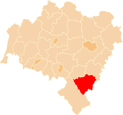 Location within the voivodeship | |
 Division into gminas | |
| Country | |
| Voivodeship | Lower Silesian |
| Seat | Ząbkowice Śląskie |
| Gminas | |
| Area | |
| • Total | 801.75 km2 (309.56 sq mi) |
| Population (2019-06-30[1]) | |
| • Total | 65,104 |
| • Density | 81/km2 (210/sq mi) |
| • Urban | 29,032 |
| • Rural | 36,072 |
| Car plates | DZA |
| Website | http://www.zabkowice-powiat.pl |
Ząbkowice Śląskie County (Polish: powiat ząbkowicki) is a unit of territorial administration and local government (powiat) in Lower Silesian Voivodeship, south-western Poland. It came into being on January 1, 1999, as a result of the Polish local government reforms passed in 1998. The county covers an area of 801.75 square kilometres (309.6 sq mi). Its administrative seat is Ząbkowice Śląskie, and it also contains the towns of Ziębice, Złoty Stok and Bardo.
As of 2019 the total population of the county is 65,104. The most populated towns are Ząbkowice Śląskie with 15,004 inhabitants and Ziębice with 8,708 inhabitants.
Neighbouring counties[]
Ząbkowice Śląskie County is bordered by Kłodzko County to the south-west, Dzierżoniów County to the north-west, Strzelin County to the north-east and Nysa County to the east. It also borders the Czech Republic to the south.
Administrative division[]
The county is subdivided into seven gminas (four urban-rural and three rural). These are listed in the following table, in descending order of population.
| Gmina | Type | Area (km2) |
Population (2019) |
Seat |
| Gmina Ząbkowice Śląskie | urban-rural | 146.9 | 21,775 | Ząbkowice Śląskie |
| Gmina Ziębice | urban-rural | 222.2 | 17,001 | Ziębice |
| Gmina Kamieniec Ząbkowicki | rural | 96.2 | 8,137 | Kamieniec Ząbkowicki |
| Gmina Stoszowice | rural | 109.8 | 5,383 | Stoszowice |
| Gmina Bardo | urban-rural | 73.4 | 5,316 | Bardo |
| Gmina Złoty Stok | urban-rural | 75.6 | 4,476 | Złoty Stok |
| Gmina Ciepłowody | rural | 77.5 | 3,016 | Ciepłowody |
References[]
- ^ "Population. Size and structure and vital statistics in Poland by territorial division in 2019. As of 30th June". stat.gov.pl. Statistics Poland. 2019-10-15. Retrieved 2020-02-14.
| Seat |  | |
|---|---|---|
| Urban-rural gminas | ||
| Rural gminas | ||
| City counties |
|  |
|---|---|---|
| Land counties | ||
- Ząbkowice Śląskie County
- Land counties of Lower Silesian Voivodeship