Zanzibar Channel
| Zanzibar Channel | |
|---|---|
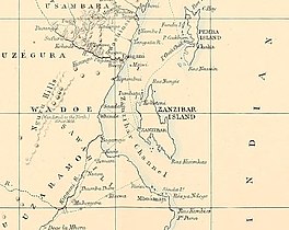 The Zanzibar Channel in an 1872 map | |
 Zanzibar Channel | |
| Coordinates | 06°00′S 39°00′E / 6.000°S 39.000°ECoordinates: 06°00′S 39°00′E / 6.000°S 39.000°E |
| Ocean/sea sources | Indian Ocean |
| Basin countries | Tanzania |
| Max. length | 110 km (68 mi) |
| Max. width | 37 km (23 mi)[1] |
| Islands | Unguja (Zanzibar) |


The Zanzibar Channel is a strait in south-eastern Africa, separating the island of Unguja (also known as Zanzibar) from mainland Tanzania. The channel is 120 km long and 29–37 km wide, with depth varying from a few dozen metres (in the centre) to a few hundred metres to the north and to the south.[2] In ancient times the overall depth of the channel has been considerably smaller (about 120 m less during the last ice age).[2]
The southern entrance to the Channel is indicated by a lighthouse located on the mainland coast on the promontory, 22 km south of Dar es Salaam.[3]
Swimming[]
In 2015, the 29 km solo swim across the Zanzibar Channel starting at the Pungume Sandbank was completed in 9 hrs 1 minute by Jean Craven (SA), Robert Dunford (Kenya), Megan Harrington Johnson (SA), Samantha Whelpton (SA) and Emil Berning (SA) [4]
References[]
- ^ Google Earth
- ^ Jump up to: a b Sediment Distribution and Transport in the Zanzibar Channel
- ^ Rowlett, Russ. "Lighthouses of Tanzania". The Lighthouse Directory. University of North Carolina at Chapel Hill.
- ^ "First ever group crossing of the Swahili Channel".
| show African seas |
|---|
| show Authority control |
|---|
This Tanzania location article is a stub. You can help Wikipedia by . |
This Zanzibar location article is a stub. You can help Wikipedia by . |
- Straits of Africa
- Straits of the Indian Ocean
- Geography of Tanzania
- Zanzibar Archipelago
- Tanzania geography stubs
- Zanzibar geography stubs