Zapol Glacier
| Zapol Glacier | |
|---|---|
 Location of Sentinel Range in Western Antarctica. | |
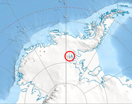
 Location of Zapol Glacier in Antarctica | |
| Location | Vinson Massif Sentinel Range Ellsworth Land |
| Coordinates |  78°35′00″S 85°51′00″W / 78.58333°S 85.85000°W / -78.58333; -85.85000 78°35′00″S 85°51′00″W / 78.58333°S 85.85000°W / -78.58333; -85.85000 |
| Thickness | unknown |
| Status | unknown |

Zapol Glacier ( WikiMiniAtlas78°35′S 85°51′W / 78.583°S 85.850°W / -78.583; -85.850) is a steep valley glacier draining the west slope of Vinson Massif south of Silverstein Peak and Príncipe de Asturias Peak, and descending between Tulaczyk Glacier and Donnellan Glacier in the Sentinel Range, Antarctica. The glacier flows southwestward and leaving the range joins Nimitz Glacier south of Hodges Knoll.
It was named by US-ACAN (2006) after Dr. Warren M. Zapol, Department of Anesthesia, Massachusetts General Hospital, whose long-term research near McMurdo Station on diving physiology of Weddell seals (begun mid-1970s) was part of a larger effort to understand how gas is handled in mammals as part of a search to understand SIDS (Sudden Infant Death Syndrome).
See also[]
- List of glaciers in the Antarctic
- Glaciology
Maps[]
- Vinson Massif. Scale 1:250 000 topographic map. Reston, Virginia: US Geological Survey, 1988.
- Antarctic Digital Database (ADD). Scale 1:250000 topographic map of Antarctica. Scientific Committee on Antarctic Research (SCAR). Since 1993, regularly updated.
External links[]
- Zapol Glacier. SCAR Composite Antarctic Gazetteer
![]() This article incorporates public domain material from the United States Geological Survey document: "Zapol Glacier". (content from the Geographic Names Information System)
This article incorporates public domain material from the United States Geological Survey document: "Zapol Glacier". (content from the Geographic Names Information System) ![]()
Glaciers in the Antarctic | |
|---|---|
|
Glaciers of Ellsworth Land | |
|---|---|
|
This article about a glacier in Ellsworth Land is a stub. You can help Wikipedia by . |
- v
- t
- Glaciers of Ellsworth Land
- Ellsworth Land glacier stubs
- Coordinates on Wikidata
- Wikipedia articles incorporating text from the USGS Geographic Names Information System
- All stub articles