Zlatni Rat
 | |
 Zlatni Rat | |
| Geography | |
|---|---|
| Location | Adriatic Sea |
| Coordinates | 43°15′21″N 16°38′02″E / 43.25583°N 16.6338°ECoordinates: 43°15′21″N 16°38′02″E / 43.25583°N 16.6338°E |
| Administration | |
| County | Split-Dalmatia County |

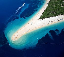
The Zlatni Rat, often referred to as the Golden Cape or Golden Horn (translated from the local Chakavian dialect), is a spit of land located about 2 kilometres (1 mile) west from the harbour town of Bol on the southern coast of the Croatian island of Brač, in the region of Dalmatia. It extends southward into the Hvar Channel, a body of water in the Adriatic Sea between the islands of Brač and Hvar, which is home to strong currents. The landform itself is mostly composed of a white pebble beach, with a Mediterranean pine grove taking up the remainder.
Zlatni Rat has been regularly listed as one of the top beaches in Europe.[1] Its distinctive shape can be seen in many travel brochures, which made it one of the symbols of Croatian tourism.[2] In 2008 Red Bull organized , a unique kiteboarding competition in jumping/flying over the beach.[3]
Description[]

The beaches on either side of the spit extend for some 634 metres (2,080 ft) altogether,[4] but the exact shape and length of the landform varies with regard to changes in tide, current, and wind. The spit points directly south. The farthest end, which is usually turned slightly toward the east, will often shift to the west in certain weather conditions, esp. a strong south-easterly wind known in Croatia as the Jugo. Changes in the shape of the beach occur once in every two to three years, and have been observed in 2010, 2016 and 2018.[5][6][7]
The surrounding waters are usually cool and clear, due to the current in the Hvar Channel. The current is mildly hazardous for swimmers who venture far southward from the tip toward the open sea, as it could be difficult to swim back west toward the beach (the swimmer being well over 150 metres (500 ft) from the coast); the danger is not severe, however, as the standard current would carry the swimmer back east toward the harbor of Bol (and the beaches on the promontory of land that lies between Zlatni Rat and the town). A reliable afternoon westerly wind known as a Maestral has made the beach a destination for windsurfers.
The pine tree grove which borders the beach is home to the remnants of a Roman villa rustica, which included a swimming pool. The westernmost edge of the beach, and several coves to the west of the main beach, are traditionally clothing-optional. The promontory is protected as a geomorphological phenomenon.[4]
See also[]
References[]
| Wikimedia Commons has media related to Zlatni rat. |
- ^ "The Best Beaches in The World". Harper's Bazaar. 20 September 2017. Retrieved 19 August 2018.
- ^ "Objave za medije - Business HTZ". press.croatia.hr. Retrieved 20 August 2017.
- ^ "Slobodna Dalmacija - Red Bull Golden Jump: Preskočili Zlatni rat". 26 May 2008.
- ^ a b Naklada Naprijed, The Croatian Adriatic Tourist Guide, p. 267, Zagreb (1999), ISBN 953-178-097-8.
- ^ "Pogledajte kako se simbol hrvatskog turizma Zlatni rat okrenuo na drugu stranu". Jutarnji.hr (in Croatian). 2 December 2010. Retrieved 9 January 2017.
- ^ "Kupači svjedoče o promjenama Zlatnog rata". Dnevnik.hr (in Croatian). 9 January 2016. Retrieved 9 January 2017.
- ^ "Skrenula plaža: Pogledajte što je snažno jugo napravilo Zlatnom ratu". Index.hr (in Croatian). 3 November 2018. Retrieved 3 November 2018.
- Bol, Croatia
- Beaches of Croatia
- Brač
- Spits of Europe
- Landforms of Split-Dalmatia County