Zschopau (river)
This article needs additional citations for verification. (September 2014) |
| Zschopau | |
|---|---|
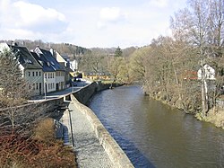 The river Zschopau in the town Zschopau | |
| Location | |
| Country | Germany |
| State | Saxony |
| Physical characteristics | |
| Source | |
| • location | Ore Mountains |
| • elevation | 1,125 m (3,691 ft) |
| Mouth | |
• location | Freiberger Mulde |
• coordinates | 51°7′46″N 13°3′7″E / 51.12944°N 13.05194°ECoordinates: 51°7′46″N 13°3′7″E / 51.12944°N 13.05194°E |
| Length | 128 km (80 mi) |
| Basin size | 1,750 km2 (680 sq mi) |
| Basin features | |
| Progression | Freiberger Mulde→ Mulde→ Elbe→ North Sea |

The Zschopau (German pronunciation: [ˈt͡ʃoːpaʊ̯], Czech: Sapava [ˈsapava] or Šopava [ˈʃopava]) is a river in Saxony, Germany, left tributary of the Freiberger Mulde. Its source is in the Erzgebirge, on the slopes of the Fichtelberg, near the border with the Czech Republic. It flows north through the towns Schlettau, Wolkenstein, Zschopau, Flöha, Frankenberg, Mittweida and Waldheim. It joins the Freiberger Mulde in the village Schweta, west of Döbeln.
The Zschopau River flows northward for 130 km (80 mi), into the Freiberger Mulde. The river has numerous roads and paths running alongside it. These trails are especially popular with cyclists. Mountain bikers often come here for tours. The undulating trails offer a brilliant riding experience to cycling enthusiasts. The trail is also known for the scenery, with castles and other medieval buildings appearing on the trail.[1]


See also[]
References[]
- ^ "The fabulous Zschopau valley". Retrieved 24 September 2013.
| Wikimedia Commons has media related to Zschopau River. |
| Authority control: National libraries |
|---|
This Ore Mountains article is a stub. You can help Wikipedia by . |
- Tributaries of the Freiberger Mulde
- Rivers of Saxony
- Rivers of the Ore Mountains
- Rivers of Germany
- Ore Mountains stubs
- Saxony river stubs