1870 Atlantic hurricane season
| 1870 Atlantic hurricane season | |
|---|---|
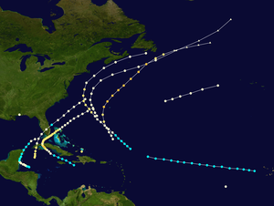 Season summary map | |
| Seasonal boundaries | |
| First system formed | July 30, 1870 |
| Last system dissipated | November 3, 1870 |
| Strongest storm | |
| Name | Four |
| • Maximum winds | 125 mph (205 km/h) (1-minute sustained) |
| • Lowest pressure | 948 mbar (hPa; 27.99 inHg) |
| Seasonal statistics | |
| Total storms | 11 |
| Hurricanes | 10 |
| Major hurricanes (Cat. 3+) | 2 |
| Total fatalities | 2,052 |
| Total damage | $12 million (1870 USD) |
The 1870 Atlantic hurricane season lasted from mid-summer to late-fall and comprised one tropical storm and ten hurricanes, two of which became major hurricanes, (Category 3+). However, in the absence of modern satellite and other remote-sensing technologies, only storms that affected populated land areas or encountered ships at sea were recorded, so the actual total could be higher. An undercount bias of zero to six tropical cyclones per year between 1851 and 1885 and zero to four per year between 1886 and 1910 has been estimated.[1]
Season summary[]
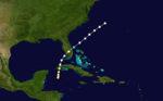
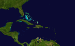
The Atlantic hurricane database (HURDAT) recognizes eleven tropical cyclones for the 1870 season. Ten storms attained hurricane status, with winds of 75 mph (119 km/h) or greater. Of the eleven Atlantic cyclones known for 1870 only three made landfall. Although Hurricane One caused damage in Alabama, the storm centre may not have crossed the coastline. Hurricane Nine made landfalls in both Cuba and Florida. Hurricane Two and Tropical Storm Three were both active in the first week of September but neither made landfall, although Hurricane Two did come close to the Newfoundland coastline. Later that month two more hurricanes were seen in the western Atlantic. Hurricane Four was an intense category three cyclone while Hurricane Five was a weaker category one storm. More notable was Hurricane Six. This hurricane, known as the Hurricane of San Marcos or the Straits of Florida Hurricane, caused massive flooding in Cuba and south Florida, resulting in 2,000 casualties [2] and at least $12 million in damages. Hurricanes Seven and Eight were also active in the first half of October, both in the mid-Atlantic.Hurricane Nine made landfalls in both Cuba and Florida and was responsible for some 52 deaths. Hurricane Ten was sighted on October 23 near the Turks and Caicos Islands.The last cyclone of the year, Hurricane Eleven made landfall in Belize.
Timeline[]

Systems[]
Hurricane One[]
| Category 1 hurricane (SSHWS) | |
 | |
| Duration | July 30 – July 30 |
|---|---|
| Peak intensity | 80 mph (130 km/h) (1-min) 985 mbar (hPa) |
The Mobile Hurricane of 1870 [3]
The first officially recognized tropical cyclone of 1870 made landfall near Mobile, Alabama, on July 30, though little is known about its genesis or track.[4][5] According to one report, barometric pressure fell to 931 mbar (27.5 inHg), but this is considered dubious.[6][7] The storm's passage was brief, with the strongest winds confined to a period of about two hours in the early afternoon.[7] Storm surge flooding damaged coastal installations along the shores of Mobile Bay, and several steamboats were either sunk or blown ashore. The winds uprooted trees, damaged roofs, and severed telegraph wires throughout Mobile. At the height of the storm, a floating dry dock broke free from its moorings and traveled about 8 mi (13 km) up the Mobile River, crushing wharves and boats along its path.[6][8] Overall, damage from the storm amounted to an estimated $200,000 (1870 USD).[6]
Hurricane Two[]
| Category 2 hurricane (SSHWS) | |
 | |
| Duration | August 30 – September 4 |
|---|---|
| Peak intensity | 105 mph (165 km/h) (1-min) |
A tropical storm formed on August 30. The storm moved northwest towards the United States, before it peaked as a Category 2 hurricane. The storm then curved back to the northeast. It travelled parallel to the coast of Nova Scotia until it was last seen on September 4 near Newfoundland.[5]
Tropical Storm Three[]
| Tropical storm (SSHWS) | |
 | |
| Duration | September 1 – September 4 |
|---|---|
| Peak intensity | 70 mph (110 km/h) (1-min) 1004 mbar (hPa) |
A tropical storm was detected to the west of Cape Verde on September 1. Tracking westward, it was encountered by another ship on September 4. The storm's subsequent progress is unknown.[9]
Hurricane Four[]
| Category 3 hurricane (SSHWS) | |
 | |
| Duration | September 9 – September 12 |
|---|---|
| Peak intensity | 125 mph (205 km/h) (1-min) 948 mbar (hPa) |
This hurricane was first encountered by a ship about 260 mi (420 km) northeast of San Juan, Puerto Rico, on September 9.[9] The storm tracked generally northward, and on September 10, it passed 90 mi (140 km) west of Bermuda.[5] There, the storm produced tropical storm-force winds that extensively damaged banana and other fruit trees.[10] Based on a central barometric pressure reading of 948 mbar (28.0 inHg) from the brig Lizzie M. Morrell, the storm is believed to have achieved major hurricane intensity.[4][11] Curving northeastward, the hurricane underwent extratropical transition by September 13.[5]
Hurricane Five[]
| Category 1 hurricane (SSHWS) | |
 | |
| Duration | September 17 – September 19 |
|---|---|
| Peak intensity | 90 mph (150 km/h) (1-min) 969 mbar (hPa) |
Numerous ships in the western Atlantic reported stormy weather from September 17 through 20. By weighting these reports according to their credibility and consistency, Partagás was able to construct an approximate recurving track for the hurricane.[12] As the system accelerated northeastward, it probably transitioned into an extratropical cyclone on September 19.[5]
Hurricane Six[]
| Category 3 hurricane (SSHWS) | |
 | |
| Duration | October 5 – October 14 |
|---|---|
| Peak intensity | 115 mph (185 km/h) (1-min) 959 mbar (hPa) |
First Key West Hurricane of 1870 or Hurricane of San Marcos of 1870 [13]
On October 5, a tropical storm developed south of Haiti. It moved west-northwest, becoming a hurricane south of Cuba on October 6. The hurricane rapidly strengthened to Category 3 with peak winds of 115 mph (185 km/h) prior to hitting Matanzas, Cuba on October 7.[14] After crossing Cuba, the hurricane moved slowly northeastward through the Florida Straits generating Category 1 winds over the Florida Keys. It moved out to sea, last being seen on October 14.[5]
The combination of sustained high winds, intensive rainfall and two rivers, the San Juan and the Yumuri, bursting their banks destroyed the city and caused the loss of some 800 lives.[14] 1,200 people died in Cuba; It was one of the deadliest hurricanes on record.[2] Damage was estimated at over $12 million (USD).[14]
Hurricane Seven[]
| Category 1 hurricane (SSHWS) | |
 | |
| Duration | October 7 – October 7 |
|---|---|
| Peak intensity | 80 mph (130 km/h) (1-min) |
On October 7, a ship, the Horatio Harris, reported a hurricane several hundred miles west of the Cape Verde Islands; this appears to be the only known record of the storm.[4] Partagás considered that the system may have been related to the subsequent tropical cyclone over the northern Atlantic, but determined this to be unlikely, given the rapid speed at which it would have needed to travel.[15]
Hurricane Eight[]
| Category 1 hurricane (SSHWS) | |
 | |
| Duration | October 10 – October 11 |
|---|---|
| Peak intensity | 80 mph (130 km/h) (1-min) |
A hurricane was first detected on October 10, more than 800 miles to the east of Bermuda.[5] Based on reports from several ships, it headed east-northeastward over the following day. Little else is known about its track.[16]
Hurricane Nine[]
| Category 2 hurricane (SSHWS) | |
 | |
| Duration | October 19 – October 22 |
|---|---|
| Peak intensity | 105 mph (165 km/h) (1-min) 970 mbar (hPa) |
Second Key West Hurricane of 1870 [13]
On October 19 a hurricane was discovered in the Caribbean. The next day it made a landfall in western Cuba as a Category 2 hurricane, causing severe damage in Batabanó and Vuelta Abajo.[4] Later on the 20th, it made landfall in Florida as a Category 1 hurricane. The centre of the hurricane passed over the Dry Tortugas, producing heavy rainfall. It later hit Chokoloskee, crossed the state, and moved out to sea. It eventually dissipated on October 22.[5] Hurricane Nine was responsible for 52 fatalities.[2]
Hurricane Ten[]
| Category 2 hurricane (SSHWS) | |
 | |
| Duration | October 23 – October 23 |
|---|---|
| Peak intensity | 105 mph (165 km/h) (1-min) |
Several ships north of Cuba and Hispaniola reported a hurricane on October 23 and 24. No further details about this storm are known.[17]
Hurricane Eleven[]
| Category 1 hurricane (SSHWS) | |
 | |
| Duration | October 30 – November 3 |
|---|---|
| Peak intensity | 80 mph (130 km/h) (1-min) |
The final storm of the season originated from an area of unsettled weather that began affecting ships in the western Caribbean Sea on October 27. It organized into a tropical cyclone several days later, and maritime reports suggest that it achieved minimal hurricane intensity. The hurricane probably curved northward and weakened upon reaching the mountainous terrain of the Yucatán Peninsula. On November 3, a ship encountered the storm at hurricane intensity in the southeastern Gulf of Mexico.[4][18]
See also[]
- Lists of hurricanes by area:
- Tropical cyclone observation
- Atlantic hurricane reanalysis project
References[]
- Specific
- ^ Landsea, C. W. (2004). "The Atlantic hurricane database re-analysis project: Documentation for the 1851–1910 alterations and additions to the HURDAT database". In Murname, R. J.; Liu, K.-B. (eds.). Hurricanes and Typhoons: Past, Present and Future. New York: Columbia University Press. pp. 177–221. ISBN 0-231-12388-4.
- ^ a b c Edward N. Rappaport & Jose Fernandez-Partagas (1996). "The Deadliest Atlantic Tropical Cyclones, 1492–1996: Cyclones with 25+ deaths". National Hurricane Center. Retrieved 2011-03-14.
- ^ Early American hurricanes 1492-1870, David Ludlum, pg 183
- ^ a b c d e Hurricane Research Division (May 2015). "Documentation of Atlantic Tropical Cyclones Changes in HURDAT". National Oceanic and Atmospheric Administration. Retrieved January 7, 2017.
- ^ a b c d e f g h Hurricane Research Division (2012). "Easy to Read HURDAT". National Oceanic and Atmospheric Administration. Retrieved January 7, 2017.
- ^ a b c Partagás, p. 58
- ^ a b Ludlum, p. 183
- ^ "Dangerous Storm at Mobile". The Times-Picayune. August 2, 1870. Retrieved January 10, 2017 – via Newspapers.com.

- ^ a b Partagás, p. 61
- ^ Tucker, p. 64
- ^ Partagás, p. 62
- ^ Partagás, pp. 62–64
- ^ a b Early American hurricanes 1492-1870, David Ludlum, pg 184
- ^ a b c Bezanilla, Alejandro (August 2000). "History: The Hurricane of Matanzas". Cuban Meteorological Society. Archived from the original on 2002-06-19. Retrieved 23 February 2010.
- ^ Partagás, p. 67
- ^ Partagás, pp. 67–68
- ^ Partagás, pp. 69–70
- ^ Partagás, p. 70
- General
- Barnes, Jay (2007). Florida's Hurricane History. Chapel Hill Press. ISBN 978-0-8078-3068-0.
- Ludlum, David M. (1963). Early American hurricanes, 1492–1870. American Meteorological Society. ISBN 0-933876-16-5.
- Partagás, José Fernández (1995). "A Reconstruction of Historical Tropical Cyclone Frequency in the Atlantic from Documentary and other Historical Sources: Year 1870" (PDF). National Oceanic and Atmospheric Administration. Retrieved January 7, 2017.
- Tucker, Terry (1996). Beware the Hurricane! The story of the cyclonic tropical storms that have struck Bermuda 1609–1995 (4th ed.). The Island Press Ltd.
- 1870s Atlantic hurricane seasons
- 1870 meteorology
- Atlantic hurricane seasons
- 1870 natural disasters