1871 Atlantic hurricane season
| 1871 Atlantic hurricane season | |
|---|---|
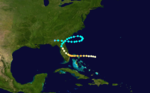
 Season summary map | |
| Seasonal boundaries | |
| First system formed | June 1, 1871 |
| Last system dissipated | October 13, 1871 |
| Strongest storm | |
| Name | Three |
| • Maximum winds | 115 mph (185 km/h) (1-minute sustained) |
| • Lowest pressure | 952 mbar (hPa; 28.11 inHg) |
| Seasonal statistics | |
| Total storms | 8 |
| Hurricanes | 6 |
| Major hurricanes (Cat. 3+) | 2 |
| Total fatalities | 35+ |
| Total damage | Unknown |
The 1871 Atlantic hurricane season lasted from mid-summer to late-fall. Records show that 1871 featured two tropical storms, four hurricanes and two major hurricanes (Category 3+). However, in the absence of modern satellite and other remote-sensing technologies, only storms that affected populated land areas or encountered ships at sea were recorded, so the actual total could be higher. According to a study in 2004, an undercount bias of zero to six tropical cyclones per year between 1851 and 1885 and zero to four per year between 1886 and 1910 is possible.[1] A later study in 2008 estimated that eight or more storms may have been missed prior to 1878.[2]
Of the known 1871 cyclones, both Hurricane Five and Hurricane Eight were first documented in 1995 by José Fernández-Partagás and Henry Díaz, who also proposed large changes to the known tracks of Hurricane Three and of Hurricane Four.[3] Further analysis, in 2008, extended the duration of both Hurricane Three and Hurricane Seven, by one day each.[4] A reanalysis published in 2014 found fifteen named storms, twelve of which became hurricanes; four attained major hurricane status. However, these results have yet to be officially accepted into HURDAT.[5]
Timeline[]

Systems[]
Tropical Storm One[]
| Tropical storm (SSHWS) | |
  | |
| Duration | June 1 – June 5 |
|---|---|
| Peak intensity | 60 mph (95 km/h) (1-min) ≤ 999 mbar (hPa) |
At 00:00 UTC on June 1, a tropical storm formed about 60 miles (95 km) east-southeast of Key West, Florida. For the next twelve hours, the system moved westward over the Straits of Florida between Cuba and the lower Florida Keys. Entering the southeastern Gulf of Mexico, the cyclone turned to the northwest and strengthened. While located 165 miles (265 km) west-northwest of the Dry Tortugas, it attained peak winds of 60 mph (95 km/h) early on June 2. Afterward, the system gradually turned to the west-northwest and maintained its intensity. As it neared the Texas coast, its course shifted to the northwest. At 07:00 UTC on June 7, the storm made landfall over San Luis Pass, 50 miles (80 km) south-southeast of Houston, at peak intensity. After landfall, the storm curved northward over East Texas, and dissipated over eastern Oklahoma late on June 5.[6] A preliminary reanalysis in 2014 upgraded the cyclone to a Category 1 hurricane at landfall in Texas.[5]

A weather station in Galveston recorded peak winds of 39 mph (63 km/h) and a total of 6 inches (152 mm) of rain during the passage of the storm,[7] of which 3.95 in (100 mm) fell in a fourteen-minute time span on June 4.[8] Another source indicated 15.57 in (395 mm) of rainfall took place, including a twenty-four-hour record of 8.55 in (217 mm) on June 4.[9] Additionally, a barometer in the area sampled a minimum peripheral pressure of 29.51 inHg (999 mb). Storm surge flooded onto and eroded Galveston Island, causing washouts of railroad beds and structures.[3] One vessel, the steamship Alabama, beached at Galveston, while another, the Virginia Dare, grounded on an offshore sandbar there. Four drownings occurred at Galveston. Gale-force winds also affected Port Aransas; very high tides occurred there and at Indianola, flooding low ground at the latter place.[9] Extremely heavy rains associated with this cyclone also caused flooding in New Orleans, which was reportedly "submerged".[10] The New York Times on June 6 reported that floodwaters covered 6 square miles (16 km2), five hundred blocks in all.[3]
Tropical Storm Two[]
| Tropical storm (SSHWS) | |
 | |
| Duration | June 8 – June 10 |
|---|---|
| Peak intensity | 60 mph (95 km/h) (1-min) ≤ 1007 mbar (hPa) |
At 00:00 UTC on June 8, the second tropical storm of the season developed 155 miles (250 km) north-northwest of Progreso, Yucatán—three days after Tropical Storm One dissipated. Taking a steady course to the northwest, the cyclone closely followed its predecessor, threatening Southeast Texas yet again. Early on June 9, the system peaked at 60 mph (95 km/h) and turned north-northwestward. At 17:00 UTC, the cyclone made landfall near present-day Jamaica Beach, 15 miles (25 km) west-southwest of Galveston, at peak intensity. After landfall, the system headed northward over the western part of Galveston Bay. Late on June 10, the cyclone dissipated over East Texas, just south of the Texas–Oklahoma border.[6]
As it affected Galveston, the storm destroyed a church and many houses. Storm surge occurred on the island for the second time in a week, as floodwaters engulfed the eastern section of Galveston Island. Several ships wrecked as well, and some sailing ships were deemed lost at sea. A cotton steamship, the Mollie Hambleton, sank while at anchor. One person died at Refugio, when winds unroofed a church. Storm surge-related flooding was minimal at Indianola.[9] Strong gales affected coastal Louisiana, and neared hurricane intensity at Lake Charles, downing fruit trees. Torrential rain damaged corn and cotton crops, and numerous cattle drowned. A tornado struck Chatawa, Mississippi, destroying a schoolhouse and trees.[10]
A reanalysis in 2014 tentatively determined that this storm and the preceding system were a single hurricane.[5]
Hurricane Three[]
| Category 3 hurricane (SSHWS) | |
 | |
| Duration | August 14 – August 23 |
|---|---|
| Peak intensity | 115 mph (185 km/h) (1-min) 952 mbar (hPa) |
Early on August 14, a report from the ship Tybee of hurricane-force winds to the east of The Bahamas signaled the presence of a well-formed system. At 00:00 UTC on August 14, the third tropical cyclone of the season was noted, 210 miles (340 km) northeast of San Salvador Island, with 90-mph (150-km/h) winds. Tracking generally westward, the hurricane gradually strengthened. At 12:00 UTC on August 15, the cyclone attained peak winds of 115 mph (185 km/h)—equivalent to Category 3 status on the modern Saffir–Simpson scale, which it maintained until landfall in Florida. Several hours later, the hurricane made landfall over the northern Abaco Islands, and continued westward toward the Gulf Stream. Early on August 16, a barque, the Bridgeport, measured a pressure of 28.1 inHg (952 mb) in the storm's eye.[3] As it neared eastern Florida, the storm curved slightly west-northwestward, before making landfall north of Hobe Sound at 02:00 UTC on August 17.[6]
Over the next few days, the cyclone parabolically turned to the northeast, re-entering the Atlantic Ocean near Darien, Georgia, on August 18. While executing a clockwise loop off the Southeastern United States, the system maintained winds just below hurricane intensity. On August 22, the system ended its loop and headed westward, toward the Georgia coast. Final landfall occurred near Brunswick at 00:00 UTC on August 23. At the time, the cyclone still contained maximum sustained winds of 70 mph (110 km/h). The system decayed as it moved inland, and dissipation took place eighteen hours later.[6]
Despite crossing The Bahamas at peak strength, damage in the archipelago, if any, is unknown. The hurricane was of great extent as it struck Florida, with hurricane-force winds occurring at New Smyrna—115 miles (185 km) from the eye. The local U.S. Army Signal Corps observer judged the storm to be the worst since October 23, 1865. In New Smyrna, the storm snapped or otherwise damaged oak and citrus trees. At Enterprise, several homes were unroofed as well. Winds destroyed another home at Ocala.[11] Numerous ships were tossed ashore,[12] leaving the beaches "strewn with wrecks".[11] Impacts to Georgia, if any, are unknown. Winds reached 60 mph (97 km/h) in Savannah, which registered a pressure of 29.55 inHg (1,001 mb).[11]
Hurricane Four[]
| Category 3 hurricane (SSHWS) | |
 | |
| Duration | August 17 – August 30 |
|---|---|
| Peak intensity | 115 mph (185 km/h) (1-min) 962 mbar (hPa) |
1871 Santa Juana Hurricane
On August 17, the fourth tropical storm of the season developed 550 miles (885 km) west-southwest of the Cape Verde islands. The system progressed on a west-northwest track and steadily intensified, becoming a major hurricane at 00:00 UTC on August 21. Bearing peak winds of 115 mph (185 km/h), the hurricane passed over Antigua, St. Eustatius, Saint Kitts, and St. Thomas. The eye passed directly over the island of Saba on 21 August 1871 at 10:00am, and the hurricane was described by the resident Catholic priest, Father Koch. "On the 21st August 1871 a devastating hurricane swept over this island. The first indications of the approach of a storm was observed during the preceding night. Marine Cumulus [storm clouds] were seen forming in the N.E. portion of the sky. Each gush of wind succeeded one another with increasing force. At half past four in the morning every one got alarmed. The barometer reading at 29.5 indicating that the storm was about 350 in distance. The clouds were moving with accelerating force towards the island. The sky was ? with a gloomy appearance, the rain commenced to fall with interruption at about 9 o'clock it burst forth with all terror. The noise was at that time terrifying. The [thatch] houses were already leveled one after the other, and the sky was covered with the debris of these and houses. Every one thought at that moment and hence awaiting of their general destruction. At about 10 o'clock the wind shifted. Then it was a dead silence. The nucleus was passing over the island. Then it began departing from the southwest all the force...".[13] Continuing northwestward, it passed 30 miles (50 km) northeast of Fajardo, Puerto Rico.[14] The hurricane then weakened to a Category 2 hurricane, maintaining this strength while making further landfalls in The Bahamas. At 05:00 UTC on August 25, the storm struck near present-day Vero Beach, Florida, with winds of 105 mph (165 km/h).[15] After crossing Central Florida, it entered the Gulf of Mexico and made a final landfall on Taylor County, Florida, as a tropical storm. The storm then moved north and east over land, weakening into a tropical depression, before strengthening back into a tropical storm after re-emerging into the Atlantic off South Carolina. At 12:00 UTC on August 30, the cyclone reattained winds of 70 mph (110 km/h). The storm was last sighted 90 miles (145 km) east of Cape Cod.[6]
The hurricane caused numerous shipwrecks, including three ships lost at Puerto Rico,[14] and left 27 people dead at St. Thomas.[16]
Hurricane Five[]
| Category 2 hurricane (SSHWS) | |
 | |
| Duration | August 30 – September 2 |
|---|---|
| Peak intensity | 105 mph (165 km/h) (1-min) |
The only storm of the year not to make landfall, Hurricane Five was first observed as a Category 2 hurricane with winds of 105 mph (165 km/h) north of Puerto Rico on August 30. Hurricane Five maintained this intensity until it was last observed south of Nova Scotia. It is possible that the storm made landfall on Nova Scotia and it is also possible that the storm formed before August 30.
Hurricane Six[]
| Category 1 hurricane (SSHWS) | |
 | |
| Duration | September 5 – September 8 |
|---|---|
| Peak intensity | 80 mph (130 km/h) (1-min) |
A hurricane formed near the geographic center of the Gulf of Mexico on September 5. At 14:00 UTC the next day, it made landfall near Cedar Key, Florida, as a Category 1 hurricane.[6] It brought heavy rainfall to Florida and Georgia before entering the Atlantic off the east coast of Georgia.[17] Still continuing to the northeast, it was last sighted south of Cape Hatteras.[6]
Hurricane Seven[]
| Category 1 hurricane (SSHWS) | |
 | |
| Duration | September 30 – October 7 |
|---|---|
| Peak intensity | 80 mph (130 km/h) (1-min) |
A tropical storm was first sighted in the Bay of Campeche on September 30. It continued moving in a northeast direction, paralleling the Texas coast and strengthening to a Category 1 hurricane while doing so. Early on October 4, the hurricane passed south of the Mississippi River Delta. At 16:00 UTC on October 5, it finally made landfall on Taylor County, Florida, as a strong tropical storm with winds of 70 mph (110 km/h). After re-entering the Atlantic Ocean, the storm was last sighted east of Cape Hatteras.[6] At least three people were killed at Galveston and several ships were wrecked or foundered, some with the loss of all hands.[9]
Hurricane Eight[]
| Category 1 hurricane (SSHWS) | |
 | |
| Duration | October 10 – October 13 |
|---|---|
| Peak intensity | 80 mph (130 km/h) (1-min) |
A hurricane was first observed northeast of the British Virgin Islands on the morning of October 10. At this point it was already a Category 1 hurricane with winds of 80 mph (130 km/h). Its intensity remained steady at that level as it traveled first west, then veered north before travelling parallel to the US coast. The hurricane dissipated shortly after making landfall at Nova Scotia on October 13.[6]
Seasonal effects[]
This is a table of the storms in 1871 and their landfall(s) in bold, if any. The minimum pressures, in most cases, are based on limited observations and may not have occurred at their peak intensity.
| Saffir–Simpson scale | ||||||
| TD | TS | C1 | C2 | C3 | C4 | C5 |
| Storm name |
Dates active | Storm category
at peak intensity |
Max 1-min wind mph (km/h) |
Min. press. (mbar) |
Areas affected | Damage (USD) |
Deaths | Ref(s)
| ||
|---|---|---|---|---|---|---|---|---|---|---|
| One | June 1–5 | Tropical storm | 60 (95) | 999 | Texas, Louisiana | Unknown | 4 | |||
| Two | June 8–10 | Tropical storm | 60 (95) | 1007 | Texas, Louisiana | Unknown | 1 | |||
| Three | August 14–23 | Category 3 hurricane | 115 (185) | 952 | The Bahamas, Florida, Georgia | Unknown | Unknown | |||
| Four | August 17–30 | Category 3 hurricane | 115 (185) | 962 | Leeward Islands, The Bahamas, Florida | Unknown | 27 | |||
| Five | August 30–September 5 | Category 2 hurricane | 105 (165) | Unknown | Nova Scotia | Unknown | Unknown | |||
| Six | September 5–September 8 | Category 1 hurricane | 80 (130) | Unknown | Florida | Unknown | Unknown | |||
| Seven | September 30–October 7 | Category 1 hurricane | 80 (130) | Unknown | Texas, Florida | Unknown | >3 | |||
| Eight | October 10–13 | Category 1 hurricane | 80 (130) | Unknown | Nova Scotia | Unknown | Unknown | |||
| Season aggregates | ||||||||||
| 8 systems | June 1–October 13 | 115 (185) | 952 | Unknown | >35 | |||||
See also[]
- 1870-1879 Atlantic hurricane seasons
- Tropical cyclone observation
- Atlantic hurricane reanalysis project
Notes[]
References[]
- ^ Landsea, C. W. (2004). "The Atlantic hurricane database re-analysis project: Documentation for the 1851–1910 alterations and additions to the HURDAT database". In Murname, R. J.; Liu, K.-B. (eds.). Hurricanes and Typhoons: Past, Present and Future. New York: Columbia University Press. pp. 177–221. ISBN 0-231-12388-4.
- ^ Vecchi, Gabriel A.; Knutson, Thomas R. (July 2008). "On Estimates of Historical North Atlantic Tropical Cyclone Activity". Journal of Climate. American Meteorological Society. 21 (14): 3588–3591. Bibcode:2008JCli...21.3580V. doi:10.1175/2008JCLI2178.1.
- ^ a b c d Partagás, J. F.; Díaz, H. F. (1995). "A Reconstruction of Historical Tropical Cyclone Frequency in the Atlantic from Documentary and other Historical Sources, Part II: 1871–1880". Year 1871 (PDF) (Report). Climate Diagnostics Center. pp. 13–15, 16–17. Retrieved 26 September 2017.
- ^ Landsea, Christopher W.; Anderson, Craig; Bredemeyer, William; et al. Documentation of Atlantic Tropical Cyclones Changes in HURDAT. Atlantic Oceanographic and Meteorological Laboratory (Report). National Oceanic and Atmospheric Administration. Retrieved 15 April 2018.
- ^ a b c Chenoweth, Michael (December 2014). "A New Compilation of North Atlantic Tropical Cyclones, 1851–98". Journal of Climate. American Meteorological Society. 27 (12): 8674–8685. Bibcode:2014JCli...27.8674C. doi:10.1175/JCLI-D-13-00771.1.
- ^ a b c d e f g h i "Atlantic hurricane best track (HURDAT version 2)" (Database). United States National Hurricane Center. May 25, 2020.
- ^ Partagás & Díaz 1995, p. 9
- ^ J. L. H. Paulhaus (1973). World Meteorological Organization Operational Hydrology Report No. 1: Manual For Estimation of Probable Maximum Precipitation. World Meteorological Organization. p. 178.
- ^ a b c d David M. Roth (17 January 2010). Texas Hurricane History (PDF) (Report). National Weather Service Southern Region Headquarters. pp. 19–20. Retrieved 26 September 2017.
- ^ a b David M. Roth (8 April 2010). Louisiana Hurricane History (PDF) (Report). National Weather Service Southern Region Headquarters. pp. 20–21. Retrieved 26 September 2017.
- ^ a b c Ho, Francis P. (March 1989). Extreme hurricanes in the nineteenth century (Technical report). National Weather Service. pp. 128–131. Hydro 43.
- ^ Partagás & Díaz 1995, p. 10
- ^ Appendix in Saba Catholic Baptismal Records, Saba, Dutch Caribbean
- ^ a b José Colón (1970). Pérez, Orlando (ed.). "Notes on the Tropical Cyclones of Puerto Rico, 1508–1970" (Pre-printed). National Weather Service: 26. Retrieved September 27, 2012. Cite journal requires
|journal=(help) - ^ "Continental United States Hurricanes (Detailed Description)". United States Hurricane Research Division. June 2020. Retrieved December 29, 2021.
- ^ Rappaport, Edward N.; Fernández-Partagás, José (22 April 1997) [28 May 1995]. "Appendix 2: Cyclones that may have 25+ deaths". The Deadliest Atlantic Tropical Cyclones, 1492–1996 (Technical report). National Weather Service, National Hurricane Center. NWS NHC 47. Retrieved 15 April 2018.
- ^ Al Sandrik & Chris Landsea (2003). "Chronological Listing of Tropical Cyclones affecting North Florida and Coastal Georgia 1565–1899". Hurricane Research Division. Archived from the original on 6 December 2006. Retrieved 2007-01-02.
- 1871 meteorology
- 1870s Atlantic hurricane seasons
- 1871 natural disasters