Dry Tortugas
 National Park Service map of the Dry Tortugas | |
 Dry Tortugas | |
| Geography | |
|---|---|
| Location | end of the Florida Keys, United States |
| Coordinates | 24°38′00″N 82°55′12″W / 24.63333°N 82.92000°WCoordinates: 24°38′00″N 82°55′12″W / 24.63333°N 82.92000°W |
| Archipelago | Florida Keys |
| Adjacent bodies of water | Gulf of Mexico |
| Total islands | 7 |
| Major islands | Garden Key |
| Area | 10,000,000 acres (4,000,000 ha) |
| Highest elevation | 10 ft (3 m)[1] |
| Administration | |
United States | |
| State | Florida |
| County | Monroe County |
| Census County Division | Lower Keys |
| Demographics | |
| Population |
|
| Additional information | |
| Time zone |
|
| • Summer (DST) |
|


The Dry Tortugas are a small group of islands, located in the Gulf of Mexico at the end of the Florida Keys, United States, about 67 miles (108 km) west of Key West, and 37 miles (60 km) west of the Marquesas Keys, the closest islands. Still farther west is the Tortugas Bank, which is submerged. The first Europeans to discover the islands were the Spanish in 1513, led by explorer Juan Ponce de León. The archipelago's name derives from the lack of fresh water springs, and the presence of turtles. They are an unincorporated area of Monroe County, Florida, and belong to the Lower Keys Census County Division, tract 9801.[2] With their surrounding waters, they constitute the Dry Tortugas National Park.
Geography[]
The keys are low and irregular. Some keys have thin growths of mangroves, and various other vegetation, while others have only small patches of grass, or are devoid of plant life. In general, they rise abruptly from relatively deep water. They are continually changing in size and shape. The Tortugas Atoll has had up to 11 islets during the past two centuries. Some of the smaller islands have disappeared and reappeared multiple times as a result of hurricane impact.
Islands[]
The total area of the islets, some of which are little more than sand bars just above the water mark, is about 58 hectares (143 acres). Their area changes over time as wind and waves reshape them. As of June 2020 there are seven islets (from west to east):
| Island | Acres | % of total |
|---|---|---|
| Total | 144.39 | 100 |
| Loggerhead Key | 64.25 | 44.49 |
| Garden Key | 42 | 29.09 |
| Bush Key | 29.65 | 20.54 |
| Long Key | 2 | 1.39 |
| Hospital Key | 0.99 | 0.69 |
| Middle Key | 1.5 | 1.04 |
| East Key | 4 | 2.77 |
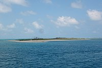
- Loggerhead Key, 250 by 1,200 m (820 by 3,940 ft) in size, with an area of 26 hectares (64 acres) is the largest. This island has the highest elevation in the Dry Tortugas, at 10 ft (3.0 m). The Dry Tortugas lighthouse, 46 m (151 ft) high, is on this island.[1]

An aerial view of Loggerhead Key

- Garden Key, with Fort Jefferson and the inactive Garden Key lighthouse (20 m (66 ft)). It is 4 km (2.5 mi) east of Loggerhead Key. Garden Key is the second largest island in the chain, at 400 by 500 m (1,300 by 1,600 ft) in size, with an area of 17 hectares (42 acres). The original size, before construction of Fort Jefferson, has been estimated at 30,350 to 35,610 m2 (7.50 to 8.80 acres).
- Bush Key, formerly named Hog Island because of the hogs that were raised there to provide fresh meat for the prisoners at Fort Jefferson, just a few meters east of Garden Key. At times, Bush Key is connected to Garden Key by a sand bar. The island is the third largest, 150 by 900 m (490 by 2,950 ft), area 12 hectares (30 acres), less than 1 m (3 ft 3 in) high. Bush Key is the site of a large tern rookery. It is closed to visitors from April to September to protect nesting sooty terns and brown noddys.
- Long Key, 59 m (194 ft) south of the eastern end of Bush Key, 50 by 200 m (160 by 660 ft) in size, area of 8,000 m2 (2.0 acres).
- Hospital Key, so called because a hospital for the inmates of Fort Jefferson had been built there in the 1870s. The island was formerly called Middle Key or Sand Key. It lies 2.5 km (1.6 mi) northeast of Garden Key and Bush Key, 70 m (230 ft). Its area is 4,000 m2 (0.99 acres), and it is 1 m (3 ft 3 in) above sea level at its highest point.
- Middle Key, 2.5 km (1.6 mi) east of Hospital key, 90 m (300 ft), area 6,000 m2 (1.5 acres). Due to various seasonal changes, storm patterns and tidal cycles it is not always above sea level, disappearing for weeks or months, only to reappear again.
- East Key, 2 km (1.2 mi) east of Middle Key, 100 by 200 m (330 by 660 ft), area 1.6 hectares (4.0 acres), over 2 m (6 ft 7 in) high.
The three westernmost keys, which are also the three largest keys (Loggerhead Key, Garden Key, and Bush Key), make up about 93 percent of the total land area of the group.
Former islands[]
Formerly existing keys were (from west to east):
- Southwest Key, disappeared by 1875, today a shoal south off of Loggerhead Reef.
- Bird Key (formerly Booby Key), was about 1.5 km (0.93 mi) southwest of Garden Key, disappeared in 1935. Current names in the area are Bird Key Bank and Bird Key Harbor. The Key was the site of numerous Union soldiers' graves during the Civil War.[3]:88
- North Key, probably identical with former Booby Island, current name in the area is North Key Harbor, an anchorage WSW of Pulaski Shoal, disappeared by 1875.
- Northeast Key (earlier called Sand Key), was between East Key and North Key, slightly to the North, disappeared by 1875.
Shoals with lights[]
- Pulaski Shoal (Pulaski Reef), marking the northeast edge of the group at 24°41′36″N 82°46′24″W / 24.69333°N 82.77333°W, is not an island, but the former location of the Pulaski Shoal Light.
- Iowa Rock, halfway between Garden Key and Hospital Key, is another site of a navigational light (and weather station) built in shallow water. It was destroyed by Hurricane Hugo, with three bare stumps left[citation needed].
Climate[]
| hideClimate data for Dry Tortugas, Florida, 1991-2020 normals, extremes 1950-present | |||||||||||||
|---|---|---|---|---|---|---|---|---|---|---|---|---|---|
| Month | Jan | Feb | Mar | Apr | May | Jun | Jul | Aug | Sep | Oct | Nov | Dec | Year |
| Record high °F (°C) | 89 (32) |
92 (33) |
93 (34) |
94 (34) |
96 (36) |
99 (37) |
98 (37) |
101 (38) |
98 (37) |
95 (35) |
90 (32) |
88 (31) |
101 (38) |
| Average high °F (°C) | 73.9 (23.3) |
75.5 (24.2) |
78.7 (25.9) |
82.7 (28.2) |
86.0 (30.0) |
89.2 (31.8) |
91.0 (32.8) |
91.4 (33.0) |
88.9 (31.6) |
85.0 (29.4) |
79.4 (26.3) |
75.7 (24.3) |
83.1 (28.4) |
| Daily mean °F (°C) | 69.3 (20.7) |
70.5 (21.4) |
73.1 (22.8) |
76.9 (24.9) |
80.3 (26.8) |
83.3 (28.5) |
84.4 (29.1) |
85.2 (29.6) |
83.4 (28.6) |
80.4 (26.9) |
74.9 (23.8) |
71.2 (21.8) |
77.7 (25.4) |
| Average low °F (°C) | 64.7 (18.2) |
65.5 (18.6) |
67.5 (19.7) |
71.1 (21.7) |
74.5 (23.6) |
77.4 (25.2) |
77.9 (25.5) |
79.0 (26.1) |
77.9 (25.5) |
75.8 (24.3) |
70.5 (21.4) |
66.6 (19.2) |
72.4 (22.4) |
| Record low °F (°C) | 46 (8) |
40 (4) |
47 (8) |
56 (13) |
55 (13) |
64 (18) |
64 (18) |
65 (18) |
66 (19) |
59 (15) |
51 (11) |
48 (9) |
40 (4) |
| Average precipitation inches (mm) | 2.35 (60) |
1.69 (43) |
2.07 (53) |
2.60 (66) |
2.02 (51) |
4.26 (108) |
2.19 (56) |
4.31 (109) |
7.18 (182) |
4.72 (120) |
1.88 (48) |
2.36 (60) |
37.63 (956) |
| Average precipitation days (≥ 0.01 in) | 6.9 | 5.7 | 4.1 | 4.2 | 4.5 | 7.4 | 8.7 | 10.4 | 11.9 | 9.8 | 4.3 | 6.1 | 84.0 |
| Source: NOAA[4][5] | |||||||||||||
Name[]
Spanish explorer Ponce de León gave the Dry Tortugas their name on his first visit in 1513. The name is the second oldest surviving European place-name in the US.[6] They were given the name Las Tortugas ("The Turtles") due to 170 sea turtles taken on the islands and shoals by de León's men. Soon afterward, the word "Dry" was added to the name, to indicate to mariners the islands' lack of springs.[7] Later seafarers would keep the turtles on their backs in the holds of sailing ships and butcher them when they wanted fresh meat.
The islands are not related to the Caribbean island of Tortuga, near Hispaniola.
Environment[]

The islands are home to Dry Tortugas National Park and are accessible only by boat or seaplane. In addition to the sea turtles for which the islands were named, the large seabird colony, including sooty terns, brown noddy, masked booby and magnificent frigatebird, and the regular occurrence of Caribbean vagrant birds makes them a popular birding destination.
History[]
In 1742 HMS Tyger wrecked in the Dry Tortugas. The stranded crew lived on Garden Key for 56 days, and fought a battle with a Spanish sloop, before sailing to Jamaica in several boats.[8]
John James Audubon visited the Tortugas in 1832 and so did Louis Agassiz in 1858.[3]:25
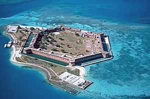
The United States government never completed Fort Jefferson after 30 years on Garden Key. This bastion remained in Union hands throughout the Civil War. It later was used as a prison until abandoned in 1874. Dr. Samuel Mudd, famous for being the doctor who treated John Wilkes Booth in the wake of the Lincoln assassination, was imprisoned here until early 1869. Also imprisoned was a leader of the "Chicago Conspiracy", Englishman George St. Leger Grenfell, who is supposed to have drowned having escaped in a small boat. During the 1880s, the Navy established a base in the Dry Tortugas, and it subsequently set up a coaling (refueling) and a wireless (radio) station there as well. During World War I, a seaplane base was established in the islands, but it was abandoned soon thereafter.
From 1903 until 1939 the Carnegie Institution of Washington operated the Marine Biology Laboratory on Loggerhead Key which "...quickly became the best-equipped marine biological station in the tropical world.”[9] Through the years, over 150 researchers used the facilities to perform a wide range of research.[10] In June 1911 the laboratory built a vessel in Miami, Anton Dohrn, for use by researchers as well as logistics between the station and Key West.[11] The vessel, excepting a period of World War I service with the Navy, supported the laboratory's work until closure in 1939 and donation of Anton Dohrn to the Woods Hole Oceanographic Institution.[12]
An account of a visit to the fort at the Dry Tortugas by President Franklin D. Roosevelt and Justice-to-be Robert H. Jackson can be found in Jackson's book That Man: An Insider's Portrait of Franklin D. Roosevelt.
The Dry Tortugas are also rich in maritime history. In 1989 Seahawk Deep Ocean Technology explored a shipwreck believed to be part of the 1622 Spanish treasure fleet. The wreck located in 1,332 ft (406 m) of water, yielded olive jars, copper, gold, silver, glass and other cultural artifacts.[13] On September 6, 1622, the Nuestra Señora de Atocha was driven by a severe hurricane onto a coral reef near the Dry Tortugas, about 35 mi (56 km) west of Key West. Mel Fisher and his company discovered the wreck July 20, 1985. The estimated $450 million cache recovered, known as "The Atocha Motherlode," included 40 tons of gold and silver; there were some 114,000 of the Spanish silver coins known as "pieces of eight", gold coins, Colombian emeralds, gold and silver artifacts, and 1,000 silver ingots.[14] In addition to the Atocha, Fisher's company, Salvors Inc., found remains of several nearby shipwrecks, including the Atocha's sister galleon the Santa Margarita, lost in the same year, and the remains of a slave ship known as the Henrietta Marie, lost in 1700.[15]
In August 2004, the Dry Tortugas were directly struck by Hurricane Charley. The following day, a Cessna airplane crashed into the water near the islands, killing cinematographer Neal Fredericks while he was filming scenery for the feature film CrossBones.[16]
Visiting[]

The Dry Tortugas are 70 mi (110 km) west of Key West, Florida. Visiting the park by private boat is difficult because of its distance, so most visitors come by ferry, catamaran, or seaplane from Key West. Other methods of visiting the Dry Tortugas include chartering of authorized and approved private vessels. Only certain companies have access to fish or dive near the Dry Tortugas. Official ferry and transportation services to the Dry Tortugas includes the Yankee Freedom III catamaran, private vessel chartering and seaplane services.[17]
In popular culture[]
- The Dry Tortugas are featured in Bob and Ray's serial.[18]
- Garden Key was the setting for James Fenimore Cooper's Jack Tier novel.[3]:13
- The Dry Tortugas are featured in the 2018 Steve Berry novel .[19]
Gallery[]

Dry Tortugas from space in 1984

View of moat and ocean from window at Fort Jefferson, March 2004

Map of Garden Key with Fort Jefferson
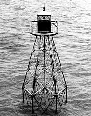
Pulaski Shoal Light

Dry Tortugas overview map


See also[]
References[]
- ^ Jump up to: a b "Loggerhead Key High Point". Peakbagger.com.
- ^ Jump up to: a b Census information. As of 2019: https://datacommons.org/place/geoId/12087980100
- ^ Jump up to: a b c Reid, Thomas (2006). America's Fortress. Gainesville, Florida: University Press of Florida. ISBN 9780813030197.
- ^ "NOWData - NOAA Online Weather Data". National Oceanic and Atmospheric Administration. Retrieved May 9, 2021.
- ^ "Summary of Monthly Normals 1991-2020". National Oceanic and Atmospheric Administration. Retrieved May 9, 2021.
- ^ Florida was named earlier, April 2, 1513, by Ponce de León – From Spanish historian Antonio de Herrera y Tordesillas's account, published in 1601 – Stewart, George (1945). Names on the Land: A Historical Account of Place-Naming in the United States. New York: Random House. p. 13. ISBN 1-59017-273-6.
- ^ Gannett, Henry (1905). The Origin of Certain Place Names in the United States. Govt. Print. Off. pp. 109.
- ^ "The Dry Tortugas and Marquesas Keys – The British Castaways of HMS Tyger". floridakeys.com. Retrieved July 6, 2007.
- ^ Trefil, James; Hazen, Margaret (2002). Good Seeing: A Century of Science at the Carnegie Institution of Washington, 1902-2002. Washington, D.C.: Joseph Henry Press. p. 51. ISBN 978-0309082617.
- ^ Snyder, Jennifer; Hargrove, Charles, eds. (December 2004). "Carnegie Institution of Washington Administration Records, 1890–2001" (PDF). Carnegie Institution of Washington Administration Archives.
- ^ Mayer, Alfred G. (1911). "Department of Marine Biology". Carnegie Institution of Washington Year Book No. 10. Washington: Carnegie Institution of Washington. 10: 120–127. Retrieved 16 July 2015.
- ^ "Anton Dohrn, 1940-1947". History of WHOI Ships. Woods Hole Oceanographic Institution. Retrieved 12 July 2015 – via whoi.edu.
- ^ Søreide, Fredrik (28 April 2011). Ships from the Depths: Deepwater Archaeology. books.google.com. ISBN 9781603442183. Retrieved 19 July 2015.
- ^ "Mel Fisher's Treasures". www.melfisher.com.
- ^ Malcom, Corey. "The Henrietta Marie an English merchant slave ship". melfisher.org. The Mel Fisher Maritime Museum. Archived from the original on 29 March 2014. Retrieved 19 July 2015.
- ^ Sainz, Adrian (August 17, 2004). "Neal Fredericks, 'Blair Witch' cinematographer, died in crash". The St. Augustine Record. Retrieved 19 July 2015.
- ^ "Directions". Dry Tortugas National Park. National Park Service. Retrieved 14 January 2013.
- ^ Internet Archive: Bob and Ray Soap Operas
- ^ Ayers, Jeff (2018-03-20). "'Bishop's Pawn' is Steve Berry's most personal novel to date". Washington Post. Associated Press. ISSN 0190-8286. Archived from the original on 2018-03-28. Retrieved 2018-03-27.
External links[]
| Wikimedia Commons has media related to Dry Tortugas. |
- Dry Tortugas National Park – Official National Park Service Site
- Plan Your Visit: Dry Tortugas National Park on YouTube by the National Park Service
- Topographic and Floristic Change of the Dry Tortugas Keys, with description and areas of keys
- Dry Tortugas National Park by Park Vision – A Photographic Guide to the Park.
- Dry Tortugas Satellite View – Google Maps
- History and Ecology of Mangroves in the Dry Tortugas
- Fort Jefferson – Florida Ghost Town
- Last Voyage of the Slave Ship Henrietta Marie – National Geographic
| show Municipalities and communities of Monroe County, Florida, United States |
|---|

| show Authority control |
|---|
- Beaches of Monroe County, Florida
- Birdwatching sites in the United States
- Dry Tortugas National Park
- Parks in Monroe County, Florida
- Uninhabited islands of Monroe County, Florida
- Atolls of the United States
- Atolls of the North Atlantic Ocean
- Beaches of Florida
- Islands of the Florida Keys