Key Largo, Florida
Key Largo, Florida | |
|---|---|
 Location in Monroe County and the state of Florida | |
 U.S. Census Bureau map showing CDP boundaries | |
| Coordinates: 25°6��24″N 80°25′48″W / 25.10667°N 80.43000°WCoordinates: 25°6′24″N 80°25′48″W / 25.10667°N 80.43000°W | |
| Country | |
| State | |
| County | Monroe |
| Area | |
| • Total | 15.3 sq mi (39.6 km2) |
| • Land | 12.2 sq mi (31.5 km2) |
| • Water | 3.1 sq mi (8.1 km2) |
| Elevation | 7 ft (2 m) |
| Population (2010) | |
| • Total | 10,433 |
| • Density | 776.9/sq mi (300.2/km2) |
| Time zone | UTC-5 (Eastern (EST)) |
| • Summer (DST) | UTC-4 (EDT) |
| ZIP code | 33037 |
| Area code(s) | 305 |
| FIPS code | 12-36375[1] |
| GNIS feature ID | 0294458[2] |

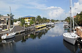
Key Largo is a census-designated place in Monroe County, Florida, United States, located on the island of Key Largo in the upper Florida Keys. The population was 10,433 at the 2010 census. The name comes from the Spanish Cayo Largo, or "long key". It is both the first island and town of the Florida Keys to be reached from the Overseas Highway to Key West. It was also the location of one of the stations of the Overseas Railroad.
Geography[]
Key Largo is located at 25°6′24″N 80°25′48″W / 25.10667°N 80.43000°W (25.106637, -80.429917).[3]
According to the United States Census Bureau, the CDP has a total area of 39.6 km2 (15.3 mi2), of which 31.5 km2 (12.2 mi2) is land and 8.1 km2 (3.1 mi2) 20.54% is water.
A southeast-pointing cape on the north end of , 24°9′12″N 80°21′30″W / 24.15333°N 80.35833°W, just south of Rattlesnake Key, is the east endpoint of the longest distance between any two points of land within the fifty states of the United States, as measured via Google Earth. The other endpoint is at the tip of a spit of sand on Green Island, Hawaii, 5,857.46 miles away.[citation needed]
Key Largo is also the location of the first undersea park in the United States, established in 1963, and called the John Pennekamp Coral Reef State Park (located at Mile Marker 102). The park is primarily offshore and stretches three miles into the Atlantic Ocean and is 25 miles long. Adjacent to this is the Florida Keys National Marine Sanctuary covering 178 square nautical miles. Both areas were designed to protect marine life, including the extensive coral reefs in the area.
Climate[]
According to the Köppen climate classification, Key Largo has a tropical monsoon climate (Am).
| hideClimate data for John Pennekamp State Park, Florida, 1991-2020 normals, extremes 2004-present | |||||||||||||
|---|---|---|---|---|---|---|---|---|---|---|---|---|---|
| Month | Jan | Feb | Mar | Apr | May | Jun | Jul | Aug | Sep | Oct | Nov | Dec | Year |
| Record high °F (°C) | 84 (29) |
89 (32) |
87 (31) |
93 (34) |
93 (34) |
94 (34) |
95 (35) |
93 (34) |
93 (34) |
91 (33) |
88 (31) |
86 (30) |
95 (35) |
| Average high °F (°C) | 76.2 (24.6) |
78.0 (25.6) |
79.7 (26.5) |
82.5 (28.1) |
85.1 (29.5) |
88.1 (31.2) |
89.8 (32.1) |
90.1 (32.3) |
88.8 (31.6) |
85.9 (29.9) |
81.4 (27.4) |
78.1 (25.6) |
83.6 (28.7) |
| Daily mean °F (°C) | 69.4 (20.8) |
71.2 (21.8) |
73.2 (22.9) |
76.6 (24.8) |
79.7 (26.5) |
82.6 (28.1) |
84.1 (28.9) |
84.5 (29.2) |
83.3 (28.5) |
80.6 (27.0) |
75.7 (24.3) |
71.9 (22.2) |
77.7 (25.4) |
| Average low °F (°C) | 62.6 (17.0) |
64.5 (18.1) |
66.8 (19.3) |
70.7 (21.5) |
74.2 (23.4) |
77.2 (25.1) |
78.5 (25.8) |
78.8 (26.0) |
77.8 (25.4) |
75.3 (24.1) |
69.9 (21.1) |
65.8 (18.8) |
71.8 (22.1) |
| Record low °F (°C) | 34 (1) |
38 (3) |
44 (7) |
52 (11) |
60 (16) |
68 (20) |
70 (21) |
71 (22) |
65 (18) |
54 (12) |
46 (8) |
37 (3) |
34 (1) |
| Average precipitation inches (mm) | 2.13 (54) |
2.01 (51) |
2.22 (56) |
3.33 (85) |
4.76 (121) |
7.91 (201) |
5.81 (148) |
6.89 (175) |
8.18 (208) |
7.87 (200) |
3.31 (84) |
2.53 (64) |
56.95 (1,447) |
| Average precipitation days (≥ 0.01 in) | 7.5 | 5.9 | 5.1 | 6.5 | 7.1 | 10.7 | 13.0 | 14.5 | 16.1 | 11.6 | 8.8 | 7.6 | 114.5 |
| Source: NOAA[4][5] | |||||||||||||
Demographics[]
| Historical population | |||
|---|---|---|---|
| Census | Pop. | %± | |
| 1970 | 2,866 | — | |
| 1980 | 7,447 | 159.8% | |
| 1990 | 11,336 | 52.2% | |
| 2000 | 12,971 | 14.4% | |
| 2010 | 10,433 | −19.6% | |
| source:[6] | |||
According to the census[1] of 2000, there were 12,971 people, 5,245 households, and 3,288 families residing in the CDP. The population density was 377.7/km2 (978.1/mi2). There were 8,043 housing units at an average density of 255.6/km2 (661.9/mi2). The racial makeup of the CDP was 94.38% White, 2.04% African American, 0.29% Native American, 0.47% Asian, 0.95% from other races, and 1.86% from two or more races. Hispanic or Latino of any race were 16.65% of the population.
There were 5,245 households, out of which 23.7% had children under the age of 18 living with them, 50.5% were married couples living together, 7.4% had a female householder with no husband present, and 37.3% were non-families. 27.6% of all households were made up of individuals, and 8.8% had someone living alone who was 65 years of age or older. The average household size was 2.26, and the average family size was 2.75.
In the CDP, the population was spread out, with 19.7% under the age of 18, 5.6% from 18 to 24, 28.7% from 25 to 44, 30.3% from 45 to 64, and 15.8% who were 65 years of age or older. The median age was 43 years. For every 100 females, there were 107.8 males. For every 100 females age 18 and over, there were 107.6 males.
The average income for a household in the CDP was $42,577, and the median income for a family was $50,755. Males had a median income of $33,588 versus $25,468 for females. The per capita income for the CDP was $25,441. About 5.9% of families and 8.3% of the population were below the poverty line, including 8.7% of those under age 18 and 7.8% of those age 65 or over.
Education[]
This section needs expansion. You can help by . (May 2020) |
The Monroe County School District operates the Key Largo School.
The Roman Catholic Archdiocese of Miami formerly operated the Saint Justin Martyr, Academy of Marine Science (PK-9) school in Key Largo.[7]
In popular culture[]
The 1948 film Key Largo, starring Edward G. Robinson, Lauren Bacall, and Humphrey Bogart, was set there. The 1981 hit single "Key Largo" by Bertie Higgins was inspired by the film, not the namesake city. Conversely, the 1984 single "Smooth Operator" by Sade references the city, rather than the film. The song "Kokomo" by the Beach Boys also references Key Largo.
Notable person[]
- Dick Rutkowski, Founder of IANTD
References[]
- ^ Jump up to: a b "U.S. Census website". United States Census Bureau. Retrieved 2008-01-31.
- ^ "US Board on Geographic Names". United States Geological Survey. 2007-10-25. Retrieved 2008-01-31.
- ^ "US Gazetteer files: 2010, 2000, and 1990". United States Census Bureau. 2011-02-12. Retrieved 2011-04-23.
- ^ "NOWData - NOAA Online Weather Data". National Oceanic and Atmospheric Administration. Retrieved June 12, 2021.
- ^ "Summary of Monthly Normals 1991-2020". National Oceanic and Atmospheric Administration. Retrieved June 12, 2021.
- ^ "CENSUS OF POPULATION AND HOUSING (1790-2000)". U.S. Census Bureau. Retrieved 2010-07-31.
- ^ "Saint Justin Martyr, Academy of Marine Science". Roman Catholic Archdiocese of Miami. 2004-02-25. Archived from the original on 2004-02-25. Retrieved 2020-05-09.
105500 Overseas Highway Key Largo, Florida 33037
External links[]
- Key Largo Chamber of Commerce Business and Tourism Development
- Monroe County School District Key Largo Public Schools
- History of Key Largo
| show Municipalities and communities of Monroe County, Florida, United States |
|---|

| show Authority control |
|---|
- Census-designated places in Monroe County, Florida
- Seaside resorts in Florida
- Populated coastal places in Florida on the Atlantic Ocean
- Census-designated places in Florida
- Key Largo