Adour
| Adour | |
|---|---|
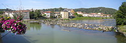 Adour seen from the bridge at Aire-sur-l'Adour | |
 | |
| Native name | L'Adour (m) (French) |
| Location | |
| Country | France |
| Physical characteristics | |
| Source | |
| • location | High-Bigorre |
| • elevation | 2,200 m (7,200 ft) |
| Mouth | |
• location | Atlantic Ocean |
• coordinates | 43°31′46″N 1°31′25″W / 43.52944°N 1.52361°WCoordinates: 43°31′46″N 1°31′25″W / 43.52944°N 1.52361°W |
| Length | 308 km (191 mi) |
| Basin size | 16,880 km2 (6,520 sq mi) |
| Discharge | |
| • average | 150 m3/s (5,300 cu ft/s) |

The Adour (French pronunciation: [aduʁ]; Basque: Aturri; Occitan: Ador) is a river in southwestern France. It rises in High-Bigorre (Pyrenees), in the commune of Aspin-Aure, and flows into the Atlantic Ocean (Bay of Biscay) near Bayonne. It is 308.3 kilometres (191.6 mi) long,[1] of which the uppermost ca. 11 kilometres (6.8 mi) is known as the Adour de Payolle. At its final stretch, i.e. on its way through Bayonne and a short extent upstream, the river draws the border between the Northern Basque Country and Landes regions.
Places along the river[]
Départements and towns along the river include:
- Hautes-Pyrénées: Bagnères-de-Bigorre, Tarbes, Maubourguet
- Gers: Riscle
- Landes: Aire-sur-l'Adour, Dax, Tarnos
- Pyrénées-Atlantiques: Bayonne
Tributaries[]

The main tributaries of the Adour are, from source to mouth:[1]
- Adour de Gripp (also Adour du Tourmalet, 15 km)
- Adour de Lesponne (19 km)
- Échez (64 km)
- Arros (130 km)
- Léez (56 km)
- Gabas (117 km)
- Midouze (151 km)
- Louts (86 km)
- Luy (154 km)
- Gave de Pau (191 km)
- Bidouze (82 km)
- Aran (48 km)
- Ardanabia (26 km)
- Nive (79 km)
References[]
External links[]
| Wikimedia Commons has media related to Adour. |
- Commission Européenne—Natura 2000: Cartographie du Barthes de l'Adour—(in French) — maps of the Adour and Adour Basin.
- Natura 2000 Sites d'Intérêt Communautaire par la France: Barthes de l'Adour — (in French)
- Gouv.fr: Natura 2000 en France—(in French) — website homepage.
- European Commission: official Natura 2000 Network website— — "the centrepiece of EU nature & biodiversity policy."
| hide Authority control | |
|---|---|
| General |
|
| National libraries | |
This Occitanie geographical article is a stub. You can help Wikipedia by . |
This Nouvelle-Aquitaine geographical article is a stub. You can help Wikipedia by . |
- Adour basin
- Rivers of Nouvelle-Aquitaine
- Rivers of Occitanie
- Natura 2000 in France
- Rivers of Gers
- Rivers of Hautes-Pyrénées
- Rivers of Landes (department)
- Rivers of Pyrénées-Atlantiques
- Rivers of France
- Occitanie geography stubs
- Nouvelle-Aquitaine geography stubs
- France river stubs