Aggtelek National Park
| Aggtelek National Park | |
|---|---|
 Stalagmite in the Baradla cave | |
| Location | Hungary |
| Coordinates | 48°28′32.628″N 20°29′12.732″E / 48.47573000°N 20.48687000°ECoordinates: 48°28′32.628″N 20°29′12.732″E / 48.47573000°N 20.48687000°E |
| Area | 198.92 km2 (76.80 sq mi) |
| Established | 1985 |
| Type | Natural |
| Criteria | viii |
| Designated | 1995 |
| Reference no. | 725 |
| State Party | |
| Region | Eastern Europe |

Aggtelek National Park (Hungarian: Aggteleki Nemzeti Park) is a national park in Northern Hungary, in the Aggtelek Karst region. The most significant values of the national park are the special surface formations and caves in this limestone landscape.[1]
Description[]
The park consists of 280 caves with different sizes.[1] It covers a total area of 198.92 km² of which 39.22 km² are under increased protection. The largest stalactite cave of Europe is situated in this area: the Baradla cave (26 km long, of which 8 km is in Slovakia, known under the name of Domica). Several of the caves have different specialities. For example, the Peace Cave has a sanatorium which help treating people suffering from asthma.
History[]
The first written documentation of the caves can be dated back to 1549. Since 1920 it has been used as a tourist attraction. The Aggtelek National Park itself was founded in 1985. It has been part of the UNESCO World Heritage since 1995 along with the Slovak Karst caves.[1]
Fauna[]
Animals present in the Aggtelek National Park included the fire salamander, hucul pony, common buzzard, eastern imperial eagle, European copper skink, white-throated dipper, red deer, Eurasian lynx, gray wolf, wild boar, crested tit, goldcrest, Eurasian bullfinch, hazel grouse, common kingfisher, red-backed shrike, old World swallowtail, scarce swallowtail and the saga pedo.
Gallery[]

Baradla Cave in Aggtelek

Vass Imre Cave in Jósvafő
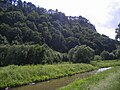
The Bódva river

Aerial photo of Esztramos-hegy


References[]
- ^ Jump up to: a b c Experience? Naturally! (1 ed.). Budapest: Ministry of Rural Development. May 2014. p. 14.
See also[]
- Caves of Aggtelek Karst and Slovak Karst UNESCO World Heritage Site
- List of national parks of Hungary
| Wikimedia Commons has media related to Aggtelek National Park. |

| show Authority control |
|---|
This Hungarian geography article is a stub. You can help Wikipedia by . |
- IUCN Category II
- National parks of Hungary
- Biosphere reserves of Hungary
- Geography of Borsod-Abaúj-Zemplén County
- Protected areas of the Western Carpathians
- Tourist attractions in Borsod-Abaúj-Zemplén County
- World Heritage Sites in Hungary
- 1985 establishments in Hungary
- Protected areas established in 1985
- Hungary geography stubs