Aghstafa (river)
| Aghstafa | |
|---|---|
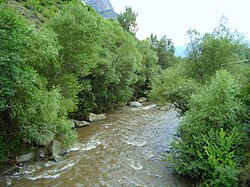 Aghstafa on the road to Dilijan | |
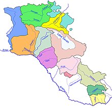 Aghstafa (Aghstev) river and its basin (yellow) within Armenia | |
| Location | |
| Country | Armenia, Azerbaijan |
| Physical characteristics | |
| Mouth | Kura |
• coordinates | 41°13′55″N 45°26′11″E / 41.2320°N 45.4364°ECoordinates: 41°13′55″N 45°26′11″E / 41.2320°N 45.4364°E |
| Length | 121 km (75 mi) |
| Basin size | 2,500 km2 (970 sq mi) |
| Basin features | |
| Progression | Kura→ Caspian Sea |
| Tributaries | |
| • right | Getik |

The Aghstafa (Armenian: Աղստև, romanized: Aghstev; Azerbaijani: Ağstafaçay) is a river in Armenia and Azerbaijan, and is a right tributary of the Kura. It is 121 km (75 mi) long, and has a drainage basin of 2,500 km2 (970 sq mi).[1]Along the river lie the cities of Dilijan, Ijevan, Gazakh and Aghstafa.[2]
See also[]
- List of lakes of Armenia
- Rivers and lakes in Azerbaijan
- Geography of Armenia
- Geography of Azerbaijan
References[]
- ^ Акстафа (река на Кавказе), Great Soviet Encyclopedia
- ^ "Rivers of Armenia". Armenia Discovery. May 3, 2019. Retrieved July 6, 2021.
| Authority control: National libraries |
|---|
Categories:
- Tributaries of the Kura (Caspian Sea)
- Rivers of Armenia
- Rivers of Azerbaijan
- International rivers of Europe
- International rivers of Asia
- Asia river stubs
- Europe river stubs
- Azerbaijan geography stubs
- Armenia geography stubs