Vorotan (river)
| Vorotan | |
|---|---|
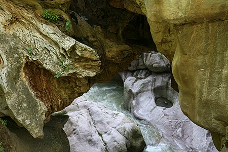
 The Vorotan in Sisian | |
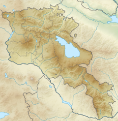 | |
| Location | |
| Countries | Armenia and Azerbaijan |
| Physical characteristics | |
| Mouth | Hakari |
• coordinates | 39°12′13″N 46°43′01″E / 39.2037°N 46.7170°ECoordinates: 39°12′13″N 46°43′01″E / 39.2037°N 46.7170°E |
| Length | 162 km (101 mi) |
| Discharge | |
| • average | 21.5 m3/s (760 cu ft/s) |
| Basin features | |
| Progression | Hakari→ Aras→ Kura→ Caspian Sea |

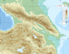

The Vorotan (Armenian: Որոտան; Azerbaijani: Bərguşad or "Bargushad"; or "Bazarchay"), is a river in Transcaucasia that is the largest right tributary of the Hakari river.[1] The river rises in the northern part of the province of Syunik in the Republic of Armenia. It then flows for 119 kilometres (74 mi) in a generally south-easterly direction through Armenia. The river then enters the territory of Azerbaijan flowing for 43 km (27 mi) through the rayons (districts) of Qubadli and Zangilan. The lower section of the Hakari, from its confluence with the Vorotan until its confluence with the Aras river, is sometimes considered to be part of the Vorotan.[2][3]
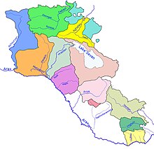
Course of the river[]
The river mostly flows through mountainous country and in several places has formed deep canyons. The towns of Sisian and Qubadli lie along its course. Six kilometers from Sisian, the river forms a waterfall — the "Shaki Waterfall" (Armenian: Շաքիի ջրվեժ) — that is 18m high.[4] The river forms a natural monument — the "Devil's Bridge" — near Tatev Monastery. There are mineral pools at the base of the travertine arch.
Damming the river[]
During the Soviet period, three reservoirs forming the Vorotan Cascade were constructed. They supply Armenia with hydro-electric power and water for irrigation. To increase the volume of water in Lake Sevan, a 21.6-kilometre (13.4 mi) tunnel was constructed to abstract some of the Vorotan's waters and divert them to the lake.[5] Begun during the 1980s, work was stopped in 1988, when only 18 km (11 mi) had been completed, because of the outbreak of the First Nagorno-Karabakh War. The Armenian government finally completed the Vorotan tunnel in 2003. Prior to this, a second tunnel — "Arpa–Sevan" — was completed in 1981.[6] This diverts some water from the Arpa River for Lake Sevan. The waters coming through the two tunnels has resulted in the lake's water level rising. In 2007 it was reported that the water level had risen by 2.44 metres (8.0 ft) in the previous six years.[7]
Gallery[]
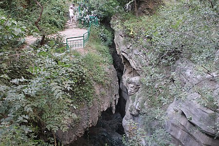
The "Devil's Bridge" natural arch near Tatev Monastery
The base of the "Devil's Bridge" 1 km from Goris

Natural arch near Karahunj village on the Goris-Kapan highway above the river

The Vorotan flowing through Qubadli District


References[]
- ^ "Հագարի" [Hagari]. Dictionary of toponyms of Armenia and adjacent regions (in Armenian). Vol. 3. Yerevan: Yerevan University Publishing House. 2001. p. 299.
- ^ Воротан, Great Soviet Encyclopedia
- ^ "Rivers of Armenia". Armenia Discovery. Retrieved July 6, 2021.
- ^ armsoul.com - Շաքիի ջրվեժ
- ^ http://arpa-sevan.am/en/1995-2003-complex-of-hydraulic-structures-for-diversion-of-the-vorotan-river-runoff-to-the-basin-of-the-arpa-river/%7Ctitle=1995-2003 “Complex of Hydraulic Structures for Diversion of the Vorotan River Runoff to the Basin of the Arpa River”
- ^ "1961-1981 the Complex of Hydraulic Works for Transfer of the Arpa and Yeghegis | Arpa Sevan".
- ^ Harutyunyan, Arpi (29 June 2007). "Sevan Rising: Lake Sevan's recovery quicker than expected". ArmeniaNow.
| Lake Sevan basin | |
|---|---|
| Caspian basin | |
- Tributaries of the Aras
- Rivers of Armenia
- Rivers of Azerbaijan
- International rivers of Europe
- International rivers of Asia
- Geography of Syunik Province
- Qubadli District