Arpa (river)
| Arpa | |
|---|---|
 Arpa river in Vayots Dzor, Armenia | |
| Location | |
| Country | Armenia, Azerbaijan |
| Physical characteristics | |
| Mouth | Aras |
• coordinates | 39°28′07″N 44°56′49″E / 39.46861°N 44.94694°ECoordinates: 39°28′07″N 44°56′49″E / 39.46861°N 44.94694°E |
| Length | 128 km (80 mi) |
| Basin size | 2,630 km2 (1,020 sq mi) |
| Basin features | |
| Progression | Aras→ Kura→ Caspian Sea |
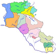
The Arpa river and its basin (light pink) within Armenia
The Arpa (Armenian: Արփա, Azerbaijani: Arpaçay) is a river that flows through Armenia and Azerbaijan's Nakhchivan exclave. It originates in the Vayots Dzor province (marz) of Armenia and is a left tributary of the Aras. It is 128 km (80 mi) long, and has a drainage basin of 2,630 km2 (1,020 sq mi).[1] It runs through many cities and towns, including Jermuk, Vayk, Yeghegnadzor, Areni, Oğlanqala, Siyaqut and Qışlaqabbas. Spandaryan Reservoir lies on the river.[2]
See also[]
References[]
- ^ Арпа, Great Soviet Encyclopedia
- ^ "Rivers of Armenia". Armenia Discovery. Retrieved July 6, 2021.
| Lake Sevan basin | |
|---|---|
| Caspian basin | |
Categories:
- Tributaries of the Aras
- Rivers of Armenia
- Rivers of Azerbaijan
- International rivers of Asia
- International rivers of Europe
- Rivers of the Republic of Artsakh