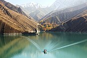
Khoda Afarin Dam
| Khoda Afarin Dam | |
|---|---|
 | |
 Location of Khoda Afarin Dam in Azerbaijan | |
| Official name | Xudafərin SES, سد خداآفرین |
| Country | Iran/Azerbaijan |
| Location | Khomarlu, East Azerbaijan Province/Soltanlı, Jabrayil Rayon |
| Coordinates | 39°9′35″N 46°56′05″E / 39.15972°N 46.93472°ECoordinates: 39°9′35″N 46°56′05″E / 39.15972°N 46.93472°E |
| Status | Operational |
| Construction began | 1999 |
| Opening date | 2008 |
| Owner(s) | Azərenerji ASC/East Azerbaijan Regional Water Authority |
| Dam and spillways | |
| Type of dam | Embankment, earth-fill |
| Impounds | Aras River |
| Height | 64 m (210 ft)[1] |
| Length | 400 m (1,300 ft)[2] |
| Reservoir | |
| Total capacity | 1,612×106 m3 (1,307,000 acre⋅ft) |
| Active capacity | 1,495×106 m3 (1,212,000 acre⋅ft)[3] |
| Power Station | |
| Installed capacity | 102 MW (137,000 hp) |
Khoda Afarin Dam (also spelled as Khodaafarin Dam or Khudafarin Dam) is an earth-fill embankment dam on the Aras River straddling the international border between Iran and Azerbaijan. It is located 8 kilometres (5.0 mi) west of Khomarlu in East Azerbaijan Province, Iran and 14 kilometres (8.7 mi) southwest of Soltanlı in Jabrayil District, Azerbaijan. Armenian de facto protectorate Republic of Artsakh occupied the area in 1993, during the First Nagorno-Karabakh War, but on 18 October 2020, the Azerbaijani forces retook control of the dam during 2020 Nagorno-Karabakh conflict.[4] It is located 1 km (0.62 mi) upstream of the Khodaafarin Bridges.
The purpose of the dam is hydroelectric power generation and irrigation. It was conceived as a joint project with the Soviet Union and both sides reached an agreement in October 1977. Designs were finalized in 1982, revised in the early 1990s and construction began in 1999.[3]
The dam was complete and began to impound water in 2008. It was inaugurated in 2010. The irrigation works are still underway.[5] During construction, several Bronze Age sites were discovered, including the grave of a Saka-Scythian warrior. The reservoir filling, or impoundment, was delayed in 2008 to accommodate excavations.[6][7] The dam's power plant has an installed capacity of 102 megawatts (137,000 hp) and is designed to irrigate 75,000 hectares (190,000 acres).[3][8]
See also[]
References[]
- ^ "Dams (>15 m) Under Construction in IRAN" (PDF). WRM. Retrieved 21 April 2012.
- ^ "Construction operation of Khoda Afarin dam power plant was begun". Farab Co. Archived from the original on 29 July 2012. Retrieved 21 April 2012.
- ^ a b c "Reducing Transboundary Degradation of Kura-Aras River Basin" (PDF). National Report of Islamic Republic of Iran. National TDA-Islamic Republic of Iran. June 2006. p. 8. Retrieved 21 April 2012.
- ^ "Азербайджан взял под контроль Худаферинский мост в Карабахе, заявил Алиев" (in Russian). RIA Novosti. 18 October 2020. Retrieved 18 October 2020.
- ^ "Khdaafryn dam will irrigate 30 thousand hectares of land in East Azarbaijan" (in Persian). WNN. 20 April 2010. Retrieved 21 April 2012.
- ^ "Archaeologists rush to save Bronze Age sites in northwestern Iran". Mehr News Agency (via Payvand Iran News). 2 December 2008. Retrieved 21 April 2012.
- ^ "Grave of a Saka-Scythian Warrior Discovered at Khoda-Afarin Dam Reservoir". The Circle of Ancient Iranian Studies. 8 December 2008.
- ^ http://www.farab.com/en/field_of_activities/prjList.asp?abv=H
- Dams completed in 2008
- Energy infrastructure completed in 2008
- Hydroelectric power stations in Iran
- Dams in Iran
- Dams in Azerbaijan
- Hydroelectric power stations in Azerbaijan
- Earth-filled dams
- Iran–Soviet Union relations
- Azerbaijan–Iran relations
- 2008 establishments in Azerbaijan
- 2008 establishments in Iran

