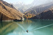
Seimare Dam
| Seimare Dam | |
|---|---|
 | |
 Location of Seimare Dam in Iran | |
| Country | Iran |
| Location | Badreh County |
| Coordinates | 33°17′28″N 47°11′55″E / 33.29111°N 47.19861°ECoordinates: 33°17′28″N 47°11′55″E / 33.29111°N 47.19861°E |
| Status | Operational[1] |
| Construction began | 1997 |
| Opening date | 2013 |
| Dam and spillways | |
| Type of dam | Arch, variable-radius |
| Impounds | Seimare River |
| Height | 180 m (591 ft) |
| Length | 202 m (663 ft) |
| Width (crest) | 6 m (20 ft) |
| Width (base) | 28 m (92 ft) |
| Dam volume | 550,000 m3 (719,373 cu yd) |
| Spillways | 2 |
| Spillway type | Main, auxiliary |
| Spillway capacity | 8,230 m3/s (290,640 cu ft/s) (total) |
| Reservoir | |
| Creates | Seimareh Reservoir |
| Total capacity | 3,200,000,000 m3 (2,594,282 acre⋅ft) |
| Catchment area | 27,886 km2 (10,767 sq mi) |
| Surface area | 69.5 km2 (27 sq mi) |
| Maximum length | 40 km (25 mi) |
| Normal elevation | 720 m (2,362 ft) |
| Coordinates | 33°16′46.12″N 47°12′36.01″E / 33.2794778°N 47.2100028°E |
| Commission date | 2013 |
| Turbines | 3 x 160 MW Francis-type |
| Installed capacity | 480 MW |
| Annual generation | 850 million kWh (est.) |
Seimare Dam, also known as Hini Mini or spelled Seymareh,[2] is an arch dam on the Seimare River in Badreh County, Ilam Province, Iran. The primary purpose of the dam is hydroelectric power generation. Studies for the dam were carried out in the mid to late 1970s and construction began on the diversion works in 1997. In 2006, concrete placement began and on 19 May 2011, the dam began to impound the river. The dam's first generator became operational in 2013. The power plant, located downstream, houses three 160 MW Francis turbine-generators with an installed capacity of 480 MW.[2][3][4]
The dam is a 180 m (591 ft) tall variable-radius arch type with a crest length of 202 m (663 ft). The dam's crest is 6 m (20 ft) wide with a base width of 28 m (92 ft) while the volume of concrete in the dam structure is 550,000 m3 (719,373 cu yd). The dam sits at the head of a 27,886 km2 (10,767 sq mi) catchment area and creates a reservoir with a 3,200,000,000 m3 (2,594,282 acre⋅ft) capacity. The reservoir's surface area is 69.5 km2 (27 sq mi) and its length 40 km (25 mi). The dam has a main and auxiliary spillway. The main spillway is controlled by two radial gates and has a maximum discharge capacity of 5,763 m3/s (203,518 cu ft/s). The auxiliary spillway is uncontrolled and has a discharge capacity of 2,467 m3/s (87,121 cu ft/s).[5]
See also[]
References[]
- ^ "Dam Projects". Mahab Ghodss. Retrieved 17 May 2013.
- ^ a b "Hydroelectric Power Plants in Iran". IndustCards. Archived from the original on 8 September 2012. Retrieved 28 May 2013.
- ^ "News: Honorable President ordered impounding of Seymareh Dam". IWPCO. Retrieved 4 July 2011.
- ^ "Seimare Project". IWPCO. Retrieved 4 July 2011.
- ^ "Seimare Project - Technical Information". IWPCO. Retrieved 4 July 2011.
- Iranian dam stubs
- Dams in Iran
- Dams completed in 2013
- Hydroelectric power stations in Iran
- Arch dams
- Buildings and structures in Ilam Province
- 2013 establishments in Iran

