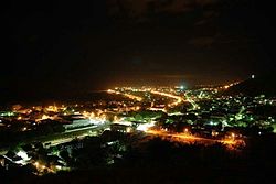
Aimorés
This article needs additional citations for verification. (January 2011) |
Aimorés | |
|---|---|
municipality | |
 | |
 Flag  Coat of arms | |
| Nickname(s): "The Land of The Eternal Sun" (A terra do sol eterno) | |
 | |
| Country | |
| State | |
| Population (2020 [1]) | |
| • Total | 25,141 |
| Demonym(s) | aimoreense |
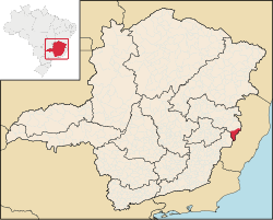
Aimorés is a municipality in the countryside of Minas Gerais. It is located on the Rio Doce Valley, 440 km east to the capital of the state, Belo Horizonte. It has 1 348.913 km² of area, with 8.2 km² being in the urban perimeter. Its population size is of 25,141 habitants. The town was founded on 18 September 1925.
Climate[]
| hideClimate data for Aimorés (1981–2010, extremes 1972–present) | |||||||||||||
|---|---|---|---|---|---|---|---|---|---|---|---|---|---|
| Month | Jan | Feb | Mar | Apr | May | Jun | Jul | Aug | Sep | Oct | Nov | Dec | Year |
| Record high °C (°F) | 40.8 (105.4) |
41.0 (105.8) |
40.0 (104.0) |
38.2 (100.8) |
37.8 (100.0) |
35.2 (95.4) |
38.2 (100.8) |
37.0 (98.6) |
42.5 (108.5) |
40.0 (104.0) |
40.6 (105.1) |
39.6 (103.3) |
42.5 (108.5) |
| Average high °C (°F) | 33.6 (92.5) |
34.7 (94.5) |
34.1 (93.4) |
32.6 (90.7) |
30.9 (87.6) |
29.6 (85.3) |
29.5 (85.1) |
30.2 (86.4) |
30.9 (87.6) |
32.1 (89.8) |
31.9 (89.4) |
32.5 (90.5) |
31.9 (89.4) |
| Daily mean °C (°F) | 27.3 (81.1) |
27.9 (82.2) |
27.4 (81.3) |
25.9 (78.6) |
23.7 (74.7) |
22.0 (71.6) |
21.8 (71.2) |
22.8 (73.0) |
24.2 (75.6) |
25.7 (78.3) |
26.0 (78.8) |
26.6 (79.9) |
25.1 (77.2) |
| Average low °C (°F) | 22.9 (73.2) |
23.0 (73.4) |
22.8 (73.0) |
21.3 (70.3) |
18.8 (65.8) |
16.8 (62.2) |
16.4 (61.5) |
17.3 (63.1) |
19.3 (66.7) |
21.1 (70.0) |
22.0 (71.6) |
22.5 (72.5) |
20.4 (68.7) |
| Record low °C (°F) | 12.5 (54.5) |
15.1 (59.2) |
16.5 (61.7) |
12.2 (54.0) |
9.9 (49.8) |
9.1 (48.4) |
9.1 (48.4) |
9.8 (49.6) |
11.0 (51.8) |
10.3 (50.5) |
13.1 (55.6) |
14.0 (57.2) |
9.1 (48.4) |
| Average precipitation mm (inches) | 145.6 (5.73) |
67.4 (2.65) |
116.2 (4.57) |
52.1 (2.05) |
34.0 (1.34) |
13.8 (0.54) |
9.9 (0.39) |
18.7 (0.74) |
29.3 (1.15) |
71.9 (2.83) |
177.5 (6.99) |
188.5 (7.42) |
924.9 (36.41) |
| Average precipitation days (≥ 1.0 mm) | 10 | 7 | 8 | 5 | 4 | 3 | 2 | 2 | 3 | 6 | 11 | 14 | 75 |
| Average relative humidity (%) | 75.9 | 72.1 | 73.8 | 74.9 | 73.2 | 72.5 | 70.7 | 69.2 | 70.2 | 70.6 | 76.1 | 77.8 | 73.1 |
| Mean monthly sunshine hours | 228.5 | 230.6 | 239.4 | 223.5 | 212.4 | 196.6 | 208.4 | 219.1 | 189.0 | 183.7 | 169.8 | 183.2 | 2,484.2 |
| Source 1: Instituto Nacional de Meteorologia[2] | |||||||||||||
| Source 2: Meteo Climat (record highs and lows)[3] | |||||||||||||
References[]
- ^ IBGE 2020
- ^ "Normais Climatológicas Do Brasil 1981–2010" (in Portuguese). Instituto Nacional de Meteorologia. Retrieved 20 October 2018.
- ^ "Station Aimores" (in French). Meteo Climat. Retrieved 20 October 2018.
Coordinates: 19°29′45″S 41°03′50″W / 19.49583°S 41.06389°W

| show |
|---|

This geographical article relating to Minas Gerais is a stub. You can help Wikipedia by . |
Categories:
- Municipalities in Minas Gerais
- Populated places established in 1925
- Minas Gerais geography stubs