Caeté
Caeté | |
|---|---|
City | |
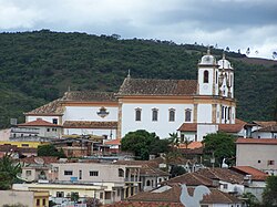 Partial view of Caeté | |
 Flag  Seal | |
 | |
 Caeté Location in Brazil | |
| Coordinates: 19°52′48″S 43°40′12″W / 19.88000°S 43.67000°WCoordinates: 19°52′48″S 43°40′12″W / 19.88000°S 43.67000°W | |
| Country | |
| Region | Southeast |
| State | Minas Gerais |
| Mesoregion | Metropolitan of Belo Horizonte |
| Microregion | |
| Settled | 17th century |
| Incorporated | February 12th, 1714 |
| Government | |
| • Mayor | Joao Antonio da Trindade |
| Area | |
| • Total | 208,918 sq mi (541,094 km2) |
| Elevation | 3,100 ft (945 m) |
| Population (2020 [2]) | |
| • Total | 45,047 |
| Time zone | UTC-3 (BRT) |
| • Summer (DST) | UTC-2 (BRST) |
| CEP | 34800-000 |
| Area code(s) | 31 |
| HDI (2010) [3] | 0.728 |
| Website | Official Website |

Caeté is a Brazilian municipality located in the state of Minas Gerais. The city belongs to the mesoregion Metropolitana de Belo Horizonte and to the microregion of Belo Horizonte.
The name Caeté is derived from the local term for some Marantaceae, in particular Stromanthe and Thalia.
The municipality contains a small part of the 31,270 hectares (77,300 acres) Serra do Gandarela National Park, created in 2014.[4]
44.9% of its population are fans of Cruzeiro while 40.2% prefer Atlético-MG.[5]
See also[]
- List of municipalities in Minas Gerais
References[]
- ^ "Área territorial oficial" [Official Territorial Area] (in Portuguese). Brazilian Institute of Geography and Statistics (IBGE). 2002-10-10. Retrieved 2010-12-05.
- ^ IBGE 2020
- ^ "Ranking decrescente do IDH-M dos municípios do Brasil" [Ranking of HDI-M of Brazilian Municipalities] (PDF) (in Portuguese). United Nations Development Programme (UNDP). 2010. Retrieved 2013-08-03.
- ^ PARNA de Serra do Gandarela (in Portuguese), ISA: Instituto Socioambiental, retrieved 2016-06-12
- ^ "Mapa das curtidas dos times do Brasil no Facebook | globoesporte.com". Globoesporte. Retrieved 2020-02-05.
| show |
|---|

| Authority control |
|
|---|
This geographical article relating to Minas Gerais is a stub. You can help Wikipedia by . |
Categories:
- Municipalities in Minas Gerais
- Populated places established in 1714
- 1714 establishments in the Portuguese Empire
- Minas Gerais geography stubs