Albany Island
Native name: Pabaju | |
|---|---|
 Albany Island (Pictured in center) | |
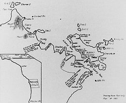 Admiralty Plan No. 1937. Plan drawn in 1862 showing site on Albany Island advised for the proposed Cape York Station, and the best position for the township on the mainland opposite. | |
| Geography | |
| Archipelago | Torres Strait Islands |
| Length | 6 km (3.7 mi) |
| Administration | |
Albany Island or Pabaju is an island off the north-eastern coast of Cape York Peninsula in the Adolphus Channel and part of the Manar Group of islands of Queensland, Australia. It is within the locality of Somerset in the Shire of Torres.[1]
Geography[]
Albany Island is off the north-eastern coast in the Cape York Peninsula about 20 km (12 mi) East of Bamaga, and 6 km (3.7 mi) southeast of the tip of Cape York. It is separated from the peninsula by the Albany Passage (10°44′21″S 142°36′00″E / 10.7392°S 142.6000°E).[2][3]
 WikiMiniAtlas
The island is a part of the Torres Strait Islands; it is about 6 km (3.7 mi) long and is volcanic with fringing coral reefs.[4] It is said to have been certainly part of the territory of the Djagaraga or Gudang people.[5]
The island was surveyed in 1848 by Owen Stanley RN and part of the island was named Port Albany (10°43′58″S 142°36′01″E / 10.7327°S 142.6004°E).[6]
A bêche-de-mer station was established on the island in 1862 by C. Edwards and J. Frazer.[7] After an inspection by Queensland's Governor Bowen, a settlement was planned for the island but it was built instead on the adjacent mainland in 1863 at Somerset, Queensland. There was still a trochus shell farm there in 1995,[8] and there is now an operational pearl farm.[9]
The wreck of the RMS Quetta, a passenger ship that sank in 1890, lies just off Albany Island. The ship hit an uncharted rock and sank in a very short time killing 134 people.[10]
History[]
Djagaraga (also known as Yadhaigana, Dyagaraga and Yagulleone) is of the languages from the tip of Cape York. The language region includes the landscape within the local government boundaries of the Northern Peninsula Area Regional Council. Traditionally the language was spoken on Eastern Cape York particularly the localities of Albany Island and Mount Adolphus Island.[11]
The island was named Albany in 1846 by Lieutenant Yule of HMS Rattlesnake, in honour of Frederick, Duke of Albany, who was the brother of King George IV. Albany Island is also closely associated with one of Queensland’s worst maritime disasters, this being the tragic sinking of the RMS Quetta. The passenger ship Quetta, struck an uncharted rock in the Adolphus Channel, just off Albany Island in 1890, with the loss of 134 people.[12]
Footnotes[]
- ^ "Albany Island – island in the Shire of Torres (entry 211)". Queensland Place Names. Queensland Government. Retrieved 2 June 2021.
- ^ "Albany Passage – passage in the Shire of Torres (entry 212)". Queensland Place Names. Queensland Government. Retrieved 2 June 2021.
- ^ "Queensland Globe". State of Queensland. Retrieved 2 June 2021.
- ^ "Archived copy". Archived from the original on 11 July 2011. Retrieved 28 December 2010.CS1 maint: archived copy as title (link)
- ^ Moore (1979), p. 299.
- ^ Great Britain. Hydrographic Department; Stanley, Owen, 1811–1850; Bate, R. B. (Robert Brettell); J. & C. Walker (1849), Australia, Port Albany, Published according to Act of Parliament, at the Hydrographic Office of the Admiralty : Sold by R.B. Bate, Agent for the Admiralty charts, 21 Poultry, retrieved 2 June 2021CS1 maint: multiple names: authors list (link)
- ^ Ganter (1994), p. 223.
- ^ Firth & Firth (1995), pp. 16–17.
- ^ "Cape York Fishing & Tour Guides – Cape York, Queensland Australia". www.capeyorkinfo.org.
- ^ "Archived copy". Archived from the original on 18 February 2011. Retrieved 28 December 2010.CS1 maint: archived copy as title (link)
- ^
 This Wikipedia article incorporates CC-BY-4.0 licensed text from: "Indigenous languages map of Queensland". State Library of Queensland. State Library of Queensland. Retrieved 5 February 2020.
- ^ "Queensland Places – Albany Island | State Library Of Queensland". www.slq.qld.gov.au. 27 November 2018. Retrieved 2 June 2021.

References[]
- Bowen, George (1864). “New Settlement at Cape York, and Survey within Great Barrier Reef,” Proceedings of the Royal Geographical Society of London, Vol. 8, No. 4 (1863–1864), pp. 114–121.
- Firth, Dawn W. and Clifford B. (1995). Cape York Peninsula. Reed Books. ISBN 0-7301-0469-9.
- Ganter, Regina (1994). The Pearl-Shellers of Torres Strait. Melbourne University Press. ISBN 0-522-84547-9.
- Moore, David R. (1979). Islanders and Aborigines at Cape York. Australian Institute of Aboriginal Studies, Canberra. ISBN 0-85575-076-6 (hard cover); ISBN 0-85575-082-0 (soft cover). USA edition: ISBN 0-391-00946-X (hard cover); ISBN 0-391-00948-6 (soft cover).Coordinates: 10°43′48″S 142°36′18″E / 10.730°S 142.605°E
| hide List of Torres Strait topics | |||||||||||||||||||
|---|---|---|---|---|---|---|---|---|---|---|---|---|---|---|---|---|---|---|---|
| Torres Strait Islands, islets, and cays |
| ||||||||||||||||||
| People, culture, communities and languages |
| ||||||||||||||||||
| Governance and legal matters |
| ||||||||||||||||||
| Buildings and structures | |||||||||||||||||||
| Other |
| ||||||||||||||||||
This Queensland protected areas related article is a stub. You can help Wikipedia by . |
This Far North Queensland geography article is a stub. You can help Wikipedia by . |
- Torres Strait Islands
- Islands of Far North Queensland
- Great Barrier Reef Marine Park
- Queensland protected area stubs
- Far North Queensland geography stubs