Trochus Island
 Trochus Island (left) with Turtle Head Island (centre) | |
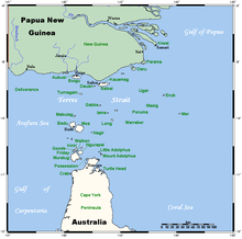 A map of the Torres Strait Islands showing Turtle Head Island in the south eastern waters of Torres Strait, east of the Cape York Peninsula | |
| Geography | |
|---|---|
| Location | Great Barrier Reef Marine Park, Northern Australia |
| Coordinates | 10°55′19″S 142°37′48″E / 10.922°S 142.630°ECoordinates: 10°55′19″S 142°37′48″E / 10.922°S 142.630°E |
| Archipelago | Torres Strait Islands |
| Adjacent bodies of water | Torres Strait |
| Area | 2.10 km2 (0.81 sq mi)[1] |
| Administration | |
| State | Queensland |
| Local government area | Shire of Torres |
| Demographics | |
| Ethnic groups | Torres Strait Islanders |

Trochus Island is an island of the Torres Strait Islands archipelago, located in the Great Barrier Reef Marine Park, east of Cape York Peninsula, in Queensland, Australia.
The island is located in Newcastle Bay at the mouth of and , not far from Jackey Jackey Creek and adjacent to the Jardine River National Park. The island lies approximately 30 km (19 mi) southeast of Bamaga and has an approximate area of 2.1 square kilometres (0.81 sq mi).[1]
Gallery[]

See also[]
References[]
- ^ Jump up to: a b "Map of Trochus Island, QLD". Bonzle Digital Atlas of Australia.
| hide List of Torres Strait topics | |||||||||||||||||||
|---|---|---|---|---|---|---|---|---|---|---|---|---|---|---|---|---|---|---|---|
| Torres Strait Islands, islets, and cays |
| ||||||||||||||||||
| People, culture, communities and languages |
| ||||||||||||||||||
| Governance and legal matters |
| ||||||||||||||||||
| Buildings and structures | |||||||||||||||||||
| Other |
| ||||||||||||||||||
This Queensland protected areas related article is a stub. You can help Wikipedia by . |
Categories:
- Islands on the Great Barrier Reef
- Torres Strait Islands
- Great Barrier Reef Marine Park
- Islands of Far North Queensland
- Queensland protected area stubs