Aldermen Islands
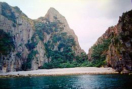 A bay on one of the Aldermen Islands. | |
| Geography | |
|---|---|
| Location | Mercury Bay in the North Island |
| Coordinates | 36°58′S 176°05′E / 36.967°S 176.083°E |
| Area | 1.3 km2 (0.50 sq mi) |
| Administration | |
| Demographics | |
| Population | 0 |

The Aldermen Islands are a small group of rocky islets to the southeast of Mercury Bay in the North Island of New Zealand. They are located off the coast of the Coromandel Peninsula, 20 kilometres (12 mi) east of the mouth of the Tairua River.
The islands were named 'the Court of Aldermen' by Captain Cook and his crew on 3 November 1769 after previously naming Mayor Island.[1] The Aldermen group consists of four main islands: , , , and . Their combined area is 133.5 ha (330 acres).[2] The islands are a forested nature reserve hosting rare species including the tuatara. Access is by permit only.
The Aldermen Islands are the remains of eroded Pliocene or Early Pleistocene lava domes that form part of the Whitianga Group.[3]
See also[]
- List of islands of New Zealand
- List of islands
- Desert island
References[]
- ^ Cook, J., Wharton, Sir W. J. L. (1968) Captain Cook's journal during his first voyage round the world, made in H. M. Bark 'Endeavour', 1768-71 : a literal transcription of the original mss ; with notes and introd. ed. by Captain W. J. L. Warton. Adelaide: Libraries Board of South Australia.
- ^ "Data Table - Protected Areas - LINZ Data Service (recorded area 133.5463 ha)". Land Information New Zealand. Retrieved 3 September 2019.
- ^ "Alderman Islands". Global Volcanism Program. Smithsonian Institution. Retrieved 12 June 2020.
Coordinates: 36°58′S 176°05′E / 36.967°S 176.083°E
This Waikato geography article is a stub. You can help Wikipedia by . |
- Uninhabited islands of New Zealand
- Thames-Coromandel District
- Islands of Waikato
- Volcanoes of Waikato
- Lava domes
- Waikato geography stubs