Algeti
| Algeti | |
|---|---|
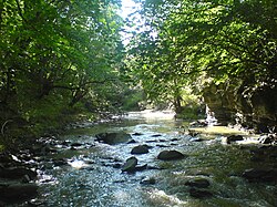 The Algeti near Manglisi | |
 | |
| Location | |
| Country | Georgia |
| Physical characteristics | |
| Source | the Lesser Caucasus Range |
| • coordinates | 41°42′41″N 44°14′01″E / 41.7113°N 44.2335°E |
| Mouth | Mtkvari (Kura) |
• coordinates | 41°22′56″N 45°02′38″E / 41.3821°N 45.0438°ECoordinates: 41°22′56″N 45°02′38″E / 41.3821°N 45.0438°E |
| Length | 118 km (73 mi) |
| Basin size | 763 km2 (295 sq mi) |
| Basin features | |
| Progression | Kura→ Caspian Sea |


The Algeti (Georgian: ალგეთი) is a river in Kvemo Kartli, Georgia, spanning the municipalities of Tetritsqaro and Marneuli. It is 118 km (73 mi) long, and has a drainage basin of 763 km2 (295 sq mi).[1] Originating at Mount Kldekari, it flows into the deep rocky valley and then a plain before joining the river Kura as its right tributary. Colorful landscapes of the Algeti valley are protected as the Algeti National Park.[2]
References[]
- ^ Statistical Yearbook of Georgia: 2020, National Statistics Office of Georgia, Tbilisi, 2020, p. 12.
- ^ Algeti National Park Archived 2011-07-21 at the Wayback Machine. Agency of Protected Areas of Georgia. Retrieved on January 7, 2010
| Wikimedia Commons has media related to Algeti River. |
Categories:
- Tributaries of the Kura (Caspian Sea)
- Rivers of Georgia (country)
- Geography of Kvemo Kartli
- Asia river stubs
- Europe river stubs
- Georgia (country) geography stubs