Alpine Loop National Back Country Byway
| Alpine Loop National Back Country Byway | |
|---|---|
| Highway system | |
Colorado State Highways
|
The Alpine Loop National Back Country Byway is located northeast of Silverton, Colorado in San Juan and Hinsdale Counties. The route is circular, running from the ghost town of Animas Forks to Lake City and return. The Byway combines crossings of and with high country scenery that features river meadows, alpine tundra, and ghost towns.
While the meadows and tundra are accessible to ordinary passenger vehicles, a high-clearance 4-wheel drive vehicle is required to travel the entire route.

Route description[]
The Alpine Loop is generally considered to begin and end at Lake City. From there the route commonly followed is west over Cinnamon Pass to Animas Forks, and then returning east over Engineer Pass back to Lake City. This clockwise circuit generally puts the vehicle on the inside "lane" of the mountainous portions (but moot because almost all is single track) with the driver on the outside, providing a better view of the relative position of the vehicle and the outer edge of the road at the top of the drop-off. [1]
Major intersections[]
| County | Location | mi | km | Destinations | Notes |
|---|---|---|---|---|---|
| Hinsdale | Lake City | 0.00 | 0.00 | Zero milepost | |
| | |||||
| | Becomes FH 30 west | ||||
| | |||||
| | |||||
| | Camp Redcloud | ||||
| | Castle Lakes Campground | ||||
| | |||||
| | |||||
| | |||||
| | Becomes FH 5 west | ||||
| San Juan | | Becomes FH 2 north | |||
| | |||||
| | |||||
| | Becomes an unmarked road | ||||
| Hinsdale | | Becomes FH 21 north | |||
| | Becomes FH 20X east | ||||
| | Becomes FH 20 east | ||||
| | |||||
| | |||||
| | |||||
| 1.000 mi = 1.609 km; 1.000 km = 0.621 mi | |||||
Alpine Loop gallery[]

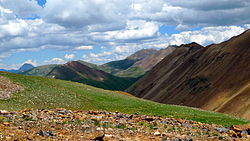
Along the road to Engineer pass
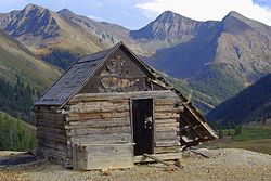
Abandoned building in Animas Forks, on the Alpine Loop

Capitol City ghost town
California Gulch Road, near Animas Forks

Signs at the start of the road in Lake City


References[]
- ^ "The Alpine Loop" (PDF). United States Department of the Interior Bureau of Land Management. Archived from the original (PDF) on 11 June 2014. Retrieved 1 February 2015.
External links[]
| Wikimedia Commons has media related to Alpine Loop National Back Country Byway. |
| Authority control |
|
|---|
This Colorado road-related article is a stub. You can help Wikipedia by . |
- Colorado Scenic Byways
- Bureau of Land Management Back Country Byways
- Bureau of Land Management areas in Colorado
- San Juan Mountains (Colorado)
- San Juan National Forest
- Transportation in Hinsdale County, Colorado
- Transportation in San Juan County, Colorado
- Tourist attractions in Hinsdale County, Colorado
- Tourist attractions in San Juan County, Colorado
- Western United States road stubs
- Colorado transportation stubs